Finström
| coat of arms | map |
|---|---|

|

|
| Basic data | |
| State : |
|
| Landscape : | Åland |
| Administrative community : | Åland Country |
| Geographical location | 60 ° 16 ′ N , 19 ° 56 ′ E |
| Surface: | 172.50 km² |
| of which land area: | 123.26 km² |
| of which inland waterways: | 6.93 km² |
| of which sea area: | 42.31 km² |
| Residents : | 2,588 (Dec 31, 2018) |
| Population density : | 21 people / km² |
| Municipality number : | 060 |
| Language (s) : | Swedish |
| Website : | www.finstrom.aland.fi |
Finström is a municipality in the autonomous Finnish province ( Finnish : Lääni ) Åland . It is located in the center of Åland's main island, Fasta Åland , surrounded by the municipalities of Hammarland in the west, Geta in the north, Jomala in the south and Saltvik and Sund in the east. Finström has 2588 inhabitants (as of December 31, 2018) and a land area of 123.26 square kilometers. As in all of Åland, Swedish is the official language.
history
The place name probably refers to the river Kyrkstrommen running through the municipality; the prefix should go back to old Norse fen , “swamp”. The place was first mentioned around 1320 as Finnaströma , which led to the assumption that the place name could have something to do with Finland; but it is probably just a typo made by the copyist who came from Åbo.
Finström was already largely settled in the time of the Vikings . The stone church dedicated to Saint Michael was built in the middle of the 15th century. King Gustav Wasa and his entourage of 312 men stayed in the community for a few days in the spring of 1556.
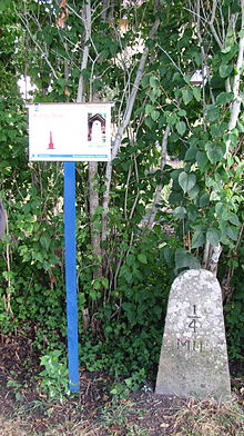
The historically significant Postvägen , a land and sea connection between Turku and Stockholm for the transport of people and goods, which existed from 1638 to 1911, ran through Godby, which belongs to Finström. A well-preserved milestone to the east of Godby reminds of this. The location was very beneficial for the development of the place: There was already a pharmacy in Godby in 1835, and in 1846 the first provincial hospital in Finland was founded here.
During the Swedish-Russian War in 1808, King Gustav IV Adolf stayed here for six weeks.
economy
The community is strongly characterized by agriculture . Finström has extensive apple-growing areas and Åland's only winery . However, there are also numerous medium-sized handicrafts and industries , and the village of Godby in Finström is the largest closed settlement in Åland outside the capital Mariehamn with around 900 inhabitants . Finally, the plays tourism a major role, favored by some 160 kilometers of shoreline at the far drawn into the hinterland bays.
politics
A new local council for Finström was elected in the local elections, which took place at the same time as the 2015 Åland parliamentary elections. The Åland Center was the strongest party ahead of the Liberals in Åland .
Worth seeing
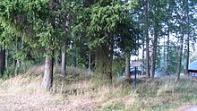
Ten grave fields from the Iron Age have been preserved in Godby, the largest of which is Gravfalt Ättekullan in the middle of the village not far from the sports hall. It consists of 57 barrows, seven of which are surrounded by boulders . Three of the graves were examined in 1933 and 1974, respectively, and remains of ceramics and iron rivets were found inside. The Postvägen ran through the southern part of the burial ground, the course of which can still be seen here.
Two of the tallest burial mounds in the entire Åland Islands are located on the Gravfalt på Knösåkern burial ground , which consists of 37 barrows from the Iron Age and the Viking Age . The burial ground apparently belonged to a certain courtyard, the location of which is still unknown. Like the others, the burial ground was for centuries a legendary place where not a few graves were opened by treasure hunters. This can still be seen today on some burial mounds by the flattened tip that resembles a crater. The first scientific investigation of the burial sites in this cemetery was carried out in 1857 by the Åland teacher Karl August Bomansson, who opened seven graves and discovered no valuables, only iron rivets and ceramic remains. In 1901 an archaeological investigation was carried out by Alfred Hackman. In total, he examined this burial ground and other 60 graves, but found only the remains of ceramics and iron rivets in addition to burnt bones.
One of the few remaining milestones in the east of the village reminds of the historically significant Postvägen , which was established in 1638 and ran through Godby. It was made around 1780 and still stands in its original location in front of the traditional Östergård farm . Most of the milestones, which were placed at 1/4 or 1/2 mile intervals, indicated the distance to Turku in Swedish miles, with one mile being 10,689 m. After the Åland Islands were ceded to Russia in 1809, the milestones were initially unchanged. It was not until 1827 that they were removed and replaced by wooden posts on which the distance to Turku was indicated in the Russian unit of length, werst . Few of the Swedish milestones have survived to this day.
The church of Finström, the Michaeliskirche in the district Pålsböle, is one of the best preserved medieval churches in all of Finland. The nave of the current building was built at the beginning and the tower at the end of the 15th century. The church is u. a. known for its wall paintings from around 1480. Behind the church, a memorial was erected in 1958 to commemorate the Åland uprising against Russian rule in 1808.
In the center of Godby, which is considered to be the center of the municipality of Finström because of its good shopping, hotels, bank and pharmacy, there is the sports center with a swimming pool, which is known far beyond the borders of Finström.
Personalities
- Annica Sjölund (* 1985), Finnish soccer player
Web links
References
- ↑ Maanmittauslaitos (Finnish land surveying office): Suomen pinta-alat kunnittain January 1, 2010 (PDF; 199 kB)
- ↑ Statistical Office Finland: Table 11ra - Key figures on population by region, 1990-2018
- ^ Matts Dreijer: The History of the Åland People. Vol. I: 1. Almqvist & Wiksell, Stockholm 1986. p. 146.
- ↑ Heiner Labonde: Finland: Åland Islands , p. 49. Offenbach 2011
- ↑ Heiner Labonde: Finland: Åland Islands , p. 167. Offenbach 2011
- ↑ Lagtings- och kommunalvalet 2015. ÅSUB Statistics, pp. 41–46 , accessed on June 11, 2019 (Swedish).
- ↑ Lagtings- och kommunalvalet 2011 ( Wayback Machine ) Statistics 7: 2011 (ÅSUB), p. 5
- ↑ Information board (in Swedish) at the burial ground
- ↑ Kjell Ekström: Åland - skärgård i Östersjön , p. 69. Mariehamn 2006
- ↑ Kjell Ekström: Åland - skärgård i Östersjön , p. 75. Mariehamn 2006
- ↑ Heiner Labonde: Finland: Åland Islands , p. 168. Offenbach 2011


