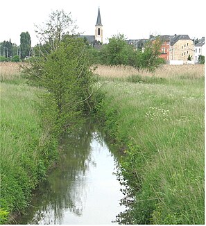
Syr (river)
| Syr | ||
|
Syr near Schüttringen |
||
| Data | ||
| location | Luxembourg | |
| River system | Rhine | |
| Drain over | Moselle → Rhine → North Sea | |
| source | at Syren 49 ° 33 '25 " N , 6 ° 12' 55" E |
|
| Source height | approx. 288 m | |
| muzzle | at Mertert in the Moselle Coordinates: 49 ° 41 ′ 54 " N , 6 ° 28 ′ 52" E 49 ° 41 ′ 54 " N , 6 ° 28 ′ 52" E |
|
| Mouth height | approx. 134 m | |
| Height difference | approx. 154 m | |
| Bottom slope | approx. 4.8 ‰ | |
| length | 32 km | |
| Catchment area | 207 km² | |
| Communities | 15th | |
| Residents in the catchment area | 35,000 | |
The Syr (Luxembourgish: Sir , French: Syre ) is a 32 km long left tributary of the Moselle in Luxembourg .
geography
course
The Syr rises near Syren at an altitude of 320 m.
It then runs in a north-easterly direction past the villages of Mutfort , Oetringen , Schrassig , Schüttringen , Übersyren, Mensdorf, Roodt-Syr, Olingen, Betzdorf , Hagelsdorf , Wecker , Manternach .
Finally it flows into the Moselle from the left at an altitude of 134 m near Mertert .
The fifteen municipalities have around 35,000 residents.
Catchment area
The water network of 234 km opens up a catchment area with an area of 207 km². Of this, 375 ha are Natura 2000 bird sanctuary, 1,835 ha Natura 2000 habitat area , 828 ha classified nature reserve and 2,298 ha potential nature reserve.
The built-up area covers 2,133 ha; Forestry accounts for 6,549 ha, agriculture 11,985 ha, viticulture 28 ha, and still waters 18 ha.
Tributaries
- Trudlerbach ( left ), 1.7 km
- Schleederbach ( left ), 0.5 km
- Kackeschbach ( left ), 1.9 km
- Birelerbach ( left ), 2.8 km
- Aefelter ( right ), 1.6 km
- Aalbach ( left ), 3.7 km
- Bouneschbach ( left ), 3.6 km
- Kuelesbach ( left ), 0.5 km
- Roudemerbach ( left ), 3.6 km
- Buusbach ( left ), 1.5 km
- Flepsbach ( left ), 2.0 km
- Fluessweilerbach ( right ), 6.0 km
- Biwerbach ( left ), 3.9 km
- Faulbich ( right) , 1.3 km
- Wuelbertsbach ( left ), 4.4 km
- Schlammbach ( left ), 3.4 km
- Foolgruet ( left ), 1.1 miles
River partnership
To develop a plan of measures to protect and improve the water quality and the river habitat, to inform and sensitize the population to the topic of water and to implement the first concrete steps, a river partnership was founded in autumn 2011 by natur & ëmwelt and the Fondation Hëllef fir d 'Nature is initiated and coordinated.

