Oetringen
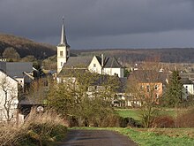
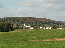
Oetringen ( lux . : Éiter , French : Oetrange ) is a medium-sized village in the Luxembourg region of Gutland . Administratively it belongs to the municipality of Contern in the canton of Luxembourg . The village is located about 13 km east of the city of Luxembourg and has 790 inhabitants (as of April 2007).
In Oetringen there is the church of the parish Oetringen-Schrassig and a train station with a signal box on the Luxembourg – Wasserbillig railway line . The train station must have played a central regional role in earlier times, as Oetringen, between Brussels , Luxembourg City , Trier and Cologne , already appears on old Ferrari maps and even older map material.
location
The place is in the valley of the Syr between Schrassig in the north and Moutfort in the south. Other neighboring villages are Canach , Greiveldange , Bous , Ersange and Sandweiler . The national road 2 between Remich and the city of Luxembourg passes a few kilometers south of the village.
history
Traces of settlement in the caves and under the rock shelters on the right and left banks of the stream near the Ötringermühle date back to prehistoric times. Nic Thill, an Oetringen teacher and hobby archaeologist, unearthed important finds in the vicinity in the 1930s. So he found parts of human skeletons and stone tools; first in a quarry below the “Kackert” farm, later also in the “Huelen Äer”, on the south-western slope of the “Heed”. The bones come from Paleolithic people who settled here around 15,000 years ago. Oetringen is one of the oldest settlements in Luxembourg.
Roman traces
Roman graves were found in the "Winkelloch", remains of a Roman villa with a water pipe in the "Willemsloch". The most important Roman settlement was on the "Hacca", near today's "Hakenhaff". Here was a large Roman villa on the important military and trade route that led from Metz via Dalheim , Medingen , Moutfort and Oetringen to Trier . A smaller path, a so-called “Diverticulum” ( lat. Side path), which connected the streets Reims-Trier and Metz-Trier, ended on the “Hacca” in the main street. The Roman villa on the “Hacca” was probably used to control passers-by in the diverticulum.
Franconian traces
Place names with the ending -ingen, such as Oetringen, usually go back to the pre-Carolingian settlement period. Probably towards the end of the Great Migration is settled Frankish and Alemannic families in Oetrange. Franconian graves were uncovered when the road from Oetringen to Canach was built at the end of the 19th century. The Franks and Alemanni, who immigrated in late antiquity, destroyed the Roman villas before they settled in their vicinity. If the Romans had avoided the swampy terrain on the banks of the Syr and preferred to settle the hills above the valley, the immigrants established their settlement in the valley. The village in its current form was created during the Frankish period. The village that emerged during this time of conquest was initially very small. Most of the present day villages consisted of only a few farms (often only one). In the 6th century, Oetringen, too, probably only consisted of two to three farms, with perhaps a maximum of 20 inhabitants. In Oetringen the population increased sharply until the end of the 1st millennium. We do not know how many "hooves" (farms) there were at that time, there are no documented mentions of Oetringen from the early Middle Ages. A church owned there very early, certainly in 983, probably as early as the 7th or 8th century.
First documentary mention
The first written mention of the village comes from 1128. After that, around the year 983, there was a drought in the diocese of Trier . The affected residents vowed to make a pilgrimage to Trier every year if their prayers were answered after rain. When the requested rain arrived, the Archbishop of Trier, Egbert von Trier , ordered the so-called ban procession to Trier in a document from 983 , which then took place every year on the Wednesday of the third week after Easter . Later, Abbot Folmar received permission from Archbishop Bruno of Trier that the more distant parts of the diocese could instead carry out the pilgrimage to Notre-Dame Abbey in Clausen . In a document from 1128 Pope Honorius II confirmed this privilege. 26 parishes now flooded to the nearby Clausen Abbey, one of the named places was Otheriga , i.e. Oetringen.
Church foundations
It was not always out of piety that a large landowner had a church built on his land. Founding a church was one of the most advantageous capital investments of the early Middle Ages. The church belonged to the property of the landlord and is therefore called an own church today. It is not known who was the landlord in Oetringen in the early Middle Ages and who was the first to have a church built. But the manorial farm, from where the administration of the village was directed, was probably already at the "Schlasswiss", near the church. This manor must have been devastated by the Croats in 1636 , because after that it is no longer mentioned in any documents.
swell
- W. Abel, History of German Agriculture, Stuttgart 1978.
- Otto Borst, Everyday Life in the Middle Ages, Frankfurt 1983.
- F. Lutge, History of the German Agrarian Constitution from the Middle Ages to the 19th Century, Stuttgart 1963.
- E. (RDC) Theisen, Schuttringen and the history of the upper Syrtal, Luxembourg 1954.
- J. Wilhelm, La Seigneurie de Munster, Luxembourg 1904.
- R. Schiel, 10 Joër Éiter Dëschtennis, Oetringen 1984.
- Administration communale de Contern
Web links
Coordinates: 49 ° 36 ' N , 6 ° 16' E

