Târnava Mica
|
Târnava Mică Small Kokel Kis-Küküllő |
||
|
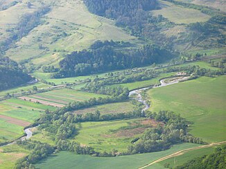
The Târnava Mică near Sângeorgiu de Pădure |
||
| Data | ||
| location | Transylvania ( Romania ) | |
| River system | Danube | |
| Drain over | Târnava → Mureș → Tisza → Danube → Black Sea | |
| source | At Praid ( Gurghiu Mountains ) | |
| Source height | 1190 m | |
| Union | At Blaj with the Târnava Mare to Târnava Coordinates: 46 ° 10 ′ 15 ″ N , 23 ° 53 ′ 32 ″ E |
|
| Mouth height | 250 m | |
| Height difference | 940 m | |
| Bottom slope | 4.8 ‰ | |
| length | 196 km | |
| Catchment area | 2071 km² | |
| Drain |
MQ |
10 m³ / s |
| Left tributaries | Corundum | |
| Medium-sized cities | Târnăveni | |
| Small towns | Sângeorgiu de Pădure | |
| Communities | Praid , Sărățeni , Ghindari , Bălăușeri , Bahnea , Gănești , Cetatea de Baltă , Jidvei , Șona | |
|
The Târnava Mică in Romania |
||
The Târnava Mică [ 'tɨrnava' mikə ] ( German the Kleine Kokel , formerly also the Kleine Kokel, Hungarian Kis-Küküllő ) is a 196 kilometer long source river of the Târnava in the Transylvania region in Romania . It rises in the Gurghiu Mountains at 1190 meters and unites at Blaj (Bubble Village) with the Târnava Mare (Great Kokel) to form Târnava. The river (with the Târnava) has a length of 219 kilometers.
Web links
Commons : Târnava Mică / Kis-Küküllő - collection of images, videos and audio files
Individual evidence
- ↑ a b Administraţia Bazinală de Mures APA. (PDF; 1.6 MB) Retrieved August 20, 2020 (Romanian).
- ↑ Kokel . In: Meyers Konversations-Lexikon . 4th edition. Volume 9, Verlag des Bibliographisches Institut, Leipzig / Vienna 1885–1892, p. 925.

