
Tüntingen
|
Tüntingen ( German ) Tënten ( lux. ) Tuntange ( French ) community Helperknapp
|
||
|---|---|---|
 |
||
| Coordinates : | 49 ° 43 ' N , 6 ° 1' E | |
| Residents : | 1232 (Sep 28, 2018) | |
| Postal code : | 7481 | |
Location of Tüntingen in Luxembourg
|
||
 Center with parish church
|
||

Tüntingen ( Luxembourgish Tënten , French Tuntange ) is a village in the municipality of Helperknapp in the Grand Duchy of Luxembourg and at the same time the seat of the municipality. Until the end of 2017 it was an independent municipality that belonged to the canton of Mersch .
Composition of the former municipality
The municipality of Tüntingen consisted of the following localities:
- Ansemburg
- Bour
- Hollenfels
- Marienthal
- Marienthalerhof
- Tüntingen
- Klaushof
- Kohlbachhof
Worth seeing
The area of the former municipality gathers a whole series of sights, which are actually of historical importance and fit into a natural landscape to this day.
The Eisch Valley is advertised under the name “Valley of the Seven Castles”. Of which can be found in the field of Tuntange the Hollenfels castle and the castle Ansembourg and the Ansembourg castle .
The Marienthal Monastery , however, is of outstanding importance for Luxembourg's history , which was only recently demonstrated by the rediscovery of the Codex Mariendalensis .

Church in Tüntingen

former Marienthal monastery
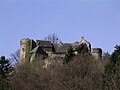
Ansemburg Castle


Individual evidence
- ^ Nombre d'habitants par localité. In: Website of the community of Helperknapp. Retrieved December 28, 2018 .