Eisch
| Eisch | ||
|
Lose the Eisch |
||
| Data | ||
| location | Belgium | |
| River system | Rhine | |
| Drain over | Alzette → Sauer → Moselle → Rhine → North Sea | |
| origin | Confluence of Menschbaach and Mille Bach west of the shock Millen 49 ° 36 '29 " N , 5 ° 52' 35" O |
|
| Source height | 322 m | |
| muzzle | at Mersch in the Alzette coordinates: 49 ° 44 ′ 57 " N , 6 ° 6 ′ 31" E 49 ° 44 ′ 57 " N , 6 ° 6 ′ 31" E |
|
| Mouth height | 214 m | |
| Height difference | 108 m | |
| Bottom slope | 2.2 ‰ | |
| length | 49.6 km | |
| Discharge at the gauge Hunnebour A Eo : 164.2 km² Location: 5.33 km above the mouth |
NNQ (01.10.2011) MNQ 2002–2012 MQ 2002–2012 Mq 2002–2012 MHQ 2002–2012 HHQ (03.01.2003) |
430 l / s 643 l / s 1.85 m³ / s 11.3 l / (s km²) 28.3 m³ / s 44.3 m³ / s |
|
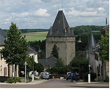
The Eisch near Simmern (Septfontaines) |
||
The Eisch ( lux. Äisch ) is a 49 km long, southwest and left tributary of the Alzette in Luxembourg .
geography
course
The Eisch arises west of Schockmillen from the confluence of the Menschbaach and Millebaach .
The upper reaches of the Eisch describes a 15 km long S-curve in a northerly direction and forms the border between the Grand Duchy and the Belgian province in the sections between Clemency and Grass, such as Steinfort and Eischen. Between Steinfort and Eischen the valley of the Eisch is gaining in depth. The Eisch crosses the village of Hobscheid and passes the edge of the municipality of Koerich .
The so-called Valley of the Seven Castles begins near Koerich. The Eisch still runs along the towns of Septfontaines, Roodt, Bour, Amsembourg and Hollenfels and finally flows into the Alzette a few meters after the Mamer at 214 m from the left .
The approximately 49.6 km long course of the Eisch ends approximately 108 meters below its source, so it has a mean bed gradient of approximately 2.2 ‰.
Tributaries
- Millebach ( right source stream ), 1.8 km
- Menschbaach ( left source stream ), 0.9 km
- Welleschbach ( right ), 3.2 km
- Grendelbach ( left ), 4.1 km
- Mouschbaach ( left ), 1.1 km
- Eiselbaach 2.8 km
- Kolerbach ( d'Autelbas ) ( left ), 7.4 km
- Ruisseau de Clairefontaine ( Durbach ) ( left ), 4.3 km
- Bech ( left ), 4.5 km
- Millebach ( Geechelbaach ) ( left ), 6.4 km
- Haardebach ( left ), 1.2 km
- Giewelerbach ( right ), 5.1 km
- Leesbech ( left ), 1.3 km
- Melleschbach ( left ), 2.0 km
- Dondelerbach (right), 2.4 kn
- Holertsbach ( left ), 2.0 km
- Fëschbech ( right ), 1.4 km
- Kalbach ( left ), 0.8 km
- Reckenerbach ( left ), 4.6 km
places
As of January 1, 2018, there are two fewer municipalities in the Eisch Valley due to the merger.
So the new community Habscht emerged from the community Hobscheid and Septfontaines, and the new community Helperknapp emerged from the community Tüntingen and Boewange.
The valley of the seven castles
There were once seven palaces or fortresses in the Eisch Valley, which is why it was named "Valley of the Seven Castles" in the early 20th century and is also advertised under this term for tourists.
- Fockeschlass and
- Gréiweschlass in Koerich ,
- Simmern Castle ,
- Hollenfels Castle ,
- Ansemburg Castle and
- Ansemburg Castle and
- the castle in Mersch .
Web links
- Course of the Eisch on the Geoportal Luxembourg
- Hunnebour station: Eisch
- Photos from the communities of the Eisch Valley
Individual evidence
- ↑ a b c Eau Geoportail Luxembourg
- ↑ Hunnebour gauge
- ↑ Valley of the Seven Castles. The official internet portal of the Grand Duchy of Luxembourg. Retrieved September 14, 2017 .


