Wallroda dam
| Wallroda dam | |||||||||
|---|---|---|---|---|---|---|---|---|---|
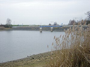
| autumn view of the reservoir, in the background the dam | |||||||||
|
|||||||||
|
|
|||||||||
| Coordinates | 51 ° 7 '4 " N , 13 ° 58' 35" E | ||||||||
| Data on the structure | |||||||||
| Construction time: | 1986-1989 | ||||||||
| Height above valley floor: | 10.1 m | ||||||||
| Height above foundation level : | 11.6 m | ||||||||
| Height of the structure crown: | 260.89 m | ||||||||
| Building volume: | 22nd 000 m³ | ||||||||
| Crown length: | 200 m | ||||||||
| Crown width: | 3 m | ||||||||
| Slope slope on the air side : | 1: 2 | ||||||||
| Slope slope on the water side : | 1: 3 | ||||||||
| Data on the reservoir | |||||||||
| Altitude (at congestion destination ) | 259.7 m | ||||||||
| Water surface | 36 ha | ||||||||
| Storage space | 0.84 million m³ | ||||||||
| Total storage space : | 1.0 million m³ | ||||||||
| Catchment area | 10.4 km² | ||||||||
| Design flood : | 2.1 m³ / s | ||||||||
The Wallroda dam is a dam in the Free State of Saxony . The dammed body of water is the Steinbach , a left tributary of the Große Röder .
General
The dam was built from 1986 to 1989 in Wallroda near Radeberg and south of Großröhrsdorf for the industrial water supply for agriculture (irrigation) and fishing. As a result, the Alte Arnsdorfer Straße , which led from northern Arnsdorf directly to Kleinröhrsdorf , was flooded and permanently interrupted. Out of town mostly unpaved it is on both sides of the lake more than small Röhrsdorfer road and Stauseeweg as Wirtschaftsweg present.
The dam was commissioned in 1989. Additional functions of the dam today are flood protection and the low water elevation of the Großer Röder. The dam is divided by a railway embankment with a railway bridge on the Kamenz-Pirna route . The water flows through this bridge from the smaller eastern part of the dam to the larger western part, which is closed by the dam.
Building
The barrier structure of the Wallroda dam is a 10 meter high and 200 meter long dam made of sand and gravel. It has an inclined, internal PVC film seal.
Freetime activities
camping
On the northern bank of the dam there is a campsite that has received multiple awards from the ADAC . A restaurant and a mini golf course are available at the lake.
to bathe
Swimming in the dam is only possible at your own risk. There are no water rescue facilities .
fishing
The dam belongs to the waters of the German Angler Association eV (D 07 - 135). Fishing is only allowed in designated areas for nature and bird protection reasons. The lake is known as a carp lake due to its very good stock of carp . There are also good stocks of pike and pikeperch . The catfish can also be found in the dam.
natural reserve
The entire dam including the adjacent forest is part of the Massenei landscape protection area . Various types of dragonflies are native to the reed-covered shores of the lake, for example the great blue arrow and the blood-red darter .
See also
Web links
Individual evidence
- ↑ Brief presentation of the campsite at the Association of the Camping and Mobile Home Industry Saxony eV (VCWS). (No longer available online.) Archived from the original on February 15, 2013 ; Retrieved July 8, 2012 . Info: The archive link was inserted automatically and has not yet been checked. Please check the original and archive link according to the instructions and then remove this notice.
- ↑ Water directory of the DAV regional association of Saxony. Retrieved July 8, 2012 .
- ↑ Information page of the Angler Association of Saxony. Retrieved July 8, 2012 .
- ↑ Interactive map of the LSG in Saxony from the Saxon State Office for Environment, Agriculture and Geology. Retrieved July 10, 2012 .


