
Tamenglong (District)
| Tamenglong District | |
|---|---|

|
|
| State | Manipur |
| Administrative headquarters : | Tamenglong |
| Area : | 4391 km² |
| Residents : | 140,651 (2011) |
| Population density : | 32 people / km² |
| Website : | official website |
The Tamenglong District is a district in the Indian state of Manipur . The administrative seat is the eponymous city of Tamenglong .
geography
The Tamenglong District is located in the west of Manipur. The area of the district is 4391 square kilometers. Large parts of the district are mountainous and are drained by numerous rivers and streams. Several mountain peaks are more than 2000 meters above sea level (Laikot 2832, Koubru 2561, Sintongbung 2437, Chabamlong 2093, Thingdoi 2080 meters above sea level). A full 88 percent of the district is covered by forest. Partly from evergreen forests. In summer, daytime temperatures reach 26 to 36 degrees. Because of the altitude, temperatures drop to 0 to 11 degrees at night in the colder months. The amount of rain varies greatly and varies from 813 mm to 3400 mm per year.
Neighboring districts are Senapati in the north and northeast, Churachandpur in the south and Imphal East in the southwest. Tamenglong borders the state of Assam to the west and the state of Nagaland to the north .
history
In the late 19th century, the British conquered the region and the area became part of Manipur within Bengal. During World War II it was close to the front line between the British and the Japanese. After Indian independence, Manipur joined India in 1949. The district was created on November 12, 1969 by dividing the Manipur territory into five districts. From November 12, 1969 to July 15, 1983, today's district was called Manipur West . On December 6, 2016, the southern part of the district was separated. This gave rise to the new Noney District .
population
According to the 2011 census, the Tamenglong district has 140,651 inhabitants. With 32 inhabitants per square kilometer, the district is only sparsely populated. The district is clearly rural. Of the residents, 121,288 people (86.23%) live in rural communities and 19,363 people in urban areas.
The Tamenglong District is one of the areas of Manipur that are almost entirely populated by members of the "tribal population" ( scheduled tribes ). Among them were (2011) 134,626 people (95.72 percent of the district population). The Dalit ( scheduled castes ) numbered 22 people in 2011 (0.02 percent of the district's population).
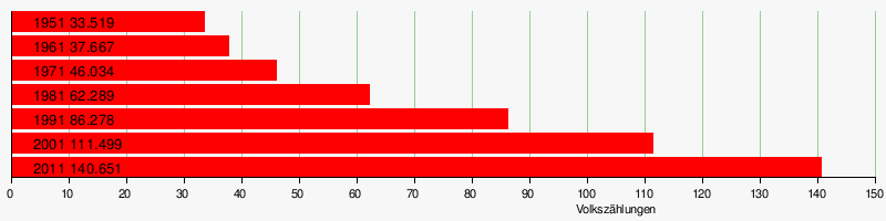
Population development
As everywhere in India, the population in the Tamenglong district has been growing rapidly for decades. The increase in the years 2001–2011 was around 26 percent (26.15%). In these ten years the population increased by around 29,000 people. The following table shows the exact numbers:
Significant places
There is only one settlement in the district with more than 10,000 residents. The small town of Tamenglong, the district capital, is the only urban settlement with 19,363 inhabitants. The urban population makes up only 13.8 percent of the total population.
District population by gender
The district originally had - very unusual for India - more female and male residents. Between 1951 and 2001 the proportion of men increased sharply. But it is now slowly falling to a normal value.
| Distribution of the population by gender in Tamenglong District | ||||||||||||||
| 1951 census | 1961 census | 1971 census | 1981 census | 1991 census | 2001 census | 2011 census | ||||||||
| number | proportion of | number | proportion of | number | proportion of | number | proportion of | number | proportion of | number | proportion of | number | proportion of | |
| TOTAL | 33,519 | 100% | 37,667 | 100% | 46,034 | 100% | 62,289 | 100% | 86,278 | 100% | 111,499 | 100% | 140,651 | 100% |
| Men | 15,979 | 47.67% | 18.303 | 48.59% | 22,867 | 49.67% | 31,538 | 50.63% | 44,593 | 51.69% | 58.014 | 52.03% | 72,371 | 51.45% |
| Women | 17,540 | 52.33% | 19,364 | 51.41% | 23,167 | 50.33% | 30,751 | 49.37% | 41,685 | 48.31% | 53,485 | 47.97% | 68,280 | 48.55% |
District population by language
Almost the entire population of Tamenglong District speaks a Tibetan Burman language . The five languages Rongmei, Liangmei, Kabui, Zemi and Thado account for almost 90 percent. Less than 2 percent of the population - mostly people who have immigrated from other regions - speak a different language. Most commonly spoken of these languages are Hindi, Bengali and Nepali.
| year | Rongmei | Liangmei | Kabui | Zemi | Thado | Gangte | Chirr | Kuki | Dogri | Hindi | Total | |||||||||||
|---|---|---|---|---|---|---|---|---|---|---|---|---|---|---|---|---|---|---|---|---|---|---|
| number | % | number | % | number | % | number | % | number | % | number | % | number | % | number | % | number | % | number | % | number | % | |
| 2001 | 49,404 | 44.31 | 25,782 | 23.12 | 9184 | 8.23 | 8037 | 7.21 | 6163 | 5.53 | 1751 | 1.57 | k.Ang. | - | 913 | 0.82 | 369 | 0.33 | 1120 | 1.00 | 111,499 | 100.00 |
| 2011 | 51,562 | 36.66 | 31,648 | 22.50 | 29,600 | 21.04 | 11,181 | 7.95 | 6112 | 4.35 | 1578 | 1.12 | 1554 | 1.10 | 1463 | 1.04 | 855 | 0.61 | 712 | 0.51 | 140,651 | 100.00 |
| Source: Results of the 2001 and 2011 censuses | ||||||||||||||||||||||
Population of the district by confession
The residents profess Christianity almost completely. The approximately 3,000 Hindus form a small minority. Since India's independence, almost all tribesmen ( scheduled tribes ) converted to Christianity. The following table shows the exact religious composition of the population:
| year | Buddhists | Christians | Hindus | Jainas | Muslims | Sikhs | Other | not specified | Total | |||||||||
|---|---|---|---|---|---|---|---|---|---|---|---|---|---|---|---|---|---|---|
| number | % | number | % | number | % | number | % | number | % | number | % | number | % | number | % | number | % | |
| 2001 | 7th | 0.01% | 105.791 | 94.88% | 3187 | 2.86% | 11 | 0.01% | 1431 | 1.28% | 67 | 0.06% | 985 | 0.88% | 20th | 0.02% | 111,499 | 100.00% |
| 2011 | 425 | 0.30% | 134,760 | 95.81% | 2995 | 2.13% | 57 | 0.04% | 589 | 0.42% | 59 | 0.04% | 1144 | 0.81% | 622 | 0.44% | 140,651 | 100.00% |
| Source: Results of the 2001 and 2011 censuses | ||||||||||||||||||
education
Despite significant efforts, the goal of full literacy has not yet been achieved. While almost 90% of men can read and write in the cities, the literacy rate of women in rural areas is just over 60%. But education has made huge strides in the last few decades. The following table shows the development:
| Literacy in Tamenglong District | ||||||
| unit | 1991 census | 2001 census | 2011 census | |||
| number | proportion of | number | proportion of | number | proportion of | |
| TOTAL | 36,039 | 50.16% | 56,819 | 59.25% | 85.006 | 70.05% |
| Men | 22,289 | 59.92% | 34,329 | 68.72% | 47,403 | 63.69% |
| Women | 13,750 | 39.68% | 22,490 | 48.95% | 37,603 | 64.09% |
| TOTAL CITY | 0 | - | 0 | - | 14,504 | 86.95% |
| City men | 0 | - | 0 | - | 7674 | 90.64% |
| City women | 0 | - | 0 | - | 6830 | 83.15% |
| TOTAL COUNTRY | 36,039 | 50.16% | 56,819 | 59.25% | 70.502 | 67.36% |
| Country men | 22,289 | 59.92% | 34,329 | 68.72% | 39,729 | 73.80% |
| Country women | 13,750 | 39.68% | 22,490 | 48.95% | 30,773 | 60.54% |
| Source: Government of Manipur, Population of Manipur 2006 and result of the 2011 census | ||||||
administration
The district was divided into four sub-divisions at the last census in 2011:
| Population in the sub-divisions | ||||||||||
| Nungba | Tamenglong | Tamenglong North | Tamenglong West | |||||||
| number | proportion of | number | proportion of | number | proportion of | number | proportion of | |||
| TOTAL | 36,671 | 100% | 48.182 | 100% | 28,056 | 100% | 27,742 | 100% | ||
| Men | 18,917 | 51.59% | 24,543 | 50.94% | 14,927 | 53.20% | 13,984 | 50.41% | ||
| Women | 17,754 | 48.41% | 23,639 | 49.06% | 13,129 | 46.80% | 13,758 | 49.59% | ||
| city | 0 | 0.00% | 19,363 | 40.19% | 0 | 0.00% | 0 | 0.00% | ||
| country | 36,671 | 100% | 28,819 | 59.81% | 28,056 | 100% | 27,742 | 100% | ||
Individual evidence
- ↑ Tamenglong District: Census 2011 data
- ↑ A - 2 DECADAL VARIATION IN POPULATION SINCE 1901
- ^ Result of the 2011 census on city population
- ^ District Census Handbook Tamenglong
Web links

Bishnupur | Chandel | Churachandpur | Imphal East | Imphal West | Jiribam | Kakching | Kamjong | Kangpokpi | Pherzawl | Noney | Senapati | Tamenglong | Tengnoupal | Thoubal | Ukhrul
Coordinates: 24 ° 35 ′ 24 ″ N , 93 ° 17 ′ 24 ″ E