Tapoa (river)
| Tapoa | ||
|
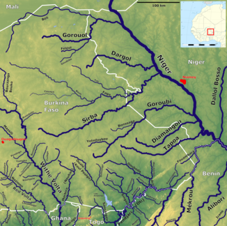
East Burkina Faso with the Tapoa (middle right) |
||
| Data | ||
| location |
|
|
| River system | Niger | |
| Drain over | Niger → Atlantic | |
| source | Matiakoali Parish 12 ° 14 ′ 30 ″ N , 0 ° 53 ′ 35 ″ E |
|
| muzzle | in Niger coordinates: 12 ° 32 ′ 55 " N , 2 ° 31 ′ 21" E 12 ° 32 ′ 55 " N , 2 ° 31 ′ 21" E
|
|
| length | 260 km | |
| Catchment area | 5500 km² | |
| Discharge at the gauge W A Eo : 5330 km² |
MNQ 1963-1967 MQ 1963-1967 Mq 1963-1967 MHQ 1963-1967 |
0 l / s 1 m³ / s 0.2 l / (s km²) 4.5 m³ / s |
|
Rock formations at the Tapoa in Niger |
||
The Tapoa is a tributary of the Niger in the states of Burkina Faso and Niger .
course
The river has a total length of 260 km and a catchment area of 5500 km². It runs roughly from west to east. It rises in the community of Matiakoali in Burkina Faso, where it crosses the N6 highway . Then he reaches the province of Tapoa named after him . There it initially forms the border between the municipality of Kantchari in the north and the municipality of Partiaga in the south. It then flows through the municipality of Diapaga , where it forms a large reservoir in front of the first Tapoa dam before it crosses the N19 road. The bed slope varies greatly depending on the river section. It is 12 cm / km in the upper reaches to Diapaga.
In the middle section, the gradient increases to 21 cm / km. The Tapoa is now the border river between the communities of Diapaga and Botou , flows through the Tapoa-Djerma hunting area and forms the northern boundary of the cross-border National Park W from the last few kilometers before the state border between Burkina Faso and Niger . The Tapoa is the border river between Burkina Faso and Niger for a good 20 kilometers before it flows on through the Nigerian community of Tamou . The 60 km long Borofwanou flows into the Tapoa as the only notable tributary . Within Niger, it marked the border between the W National Park in the south and the Tamou game reserve in the north. The second Tapoa dam , built not far from the village of La Tapoa , is primarily used to supply the wild animals with water during the dry season. Here the river falls about 20 meters at a waterfall.
The gradient reaches 70 cm / km from the second Tapoa valley weir to the confluence with the Niger River. The Tapoa finally flows curvy through a narrow gorge.
Hydrometry
Average monthly flow of the Tapoa measured at the hydrological station named W in m³ / s.

geology
The gentle lowlands which flows through the Tapoa in its upper reaches, are one body area of granite and dolerite .
The relief, which is more pronounced in the lower reaches, consists of sedimentary formations and sandstone from the Paleozoic . There are phosphate stores in the Nigerian section of the Tapoa . In 1981 , Niger signed an agreement with Nigeria to exploit them , but mining has barely progressed since then.
Web links
Individual evidence
- ↑ a b c d e Y. Brunet-Moret, P. Chaperon, JP Lamagat, M. Molinier: Monographie hydrologique du fleuve Niger . Tome II: Cuvette Lacustre et Niger Moyen. Orstom, Paris 1986, ISBN 2-7099-0790-9 , pp. 261 ( hydrosciences.fr [PDF; accessed September 25, 2018]).
- ↑ a b Monograph Hydrologique du Bassin du Niger - 1ère Partie le Niger Superieur et le Bani
- ^ A b Y. Brunet-Moret, P. Chaperon, JP Lamagat, M. Molinier: Monographie hydrologique du fleuve Niger . Tome II: Cuvette Lacustre et Niger Moyen. Orstom, Paris 1986, ISBN 2-7099-0790-9 , pp. 276 ( hydrosciences.fr [PDF; accessed September 25, 2018]).
- ↑ Inventaire des petits barrages du Niger . Economic Commission for Africa (UNECA), December 1996, p. 5–6 ( repository.uneca.org [PDF; accessed September 23, 2018]).
- ↑ Abdourahmane Idrissa, Samuel Decalo: Historical Dictionary of Niger . 4th edition. Scarecrow, Plymouth 2012, ISBN 978-0-8108-6094-0 , pp. 429 .

