Tassili n'Ajjer
| Tassili n'Ajjer | |
|---|---|
|
UNESCO world heritage |
|

|
|
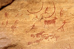
| Rock painting in Tassili n'Ajjer |
|
| National territory: |
|
| Type: | mixed |
| Criteria : | (i) (iii) (vii) (viii) |
| Surface: | 7,200,000 ha |
| Reference No .: | 179 |
| UNESCO region : | Arabic states |
| History of enrollment | |
| Enrollment: | 1982 ( session 6 ) |
The Tassili n'Ajjer ( Central Atlas Tamazight ⵜⴰⵙⵉⵍⵉ ⵏ ⴰⵊⵊⵔ Tasili n Ajjer , Arabic طاسيلي ناجّر, DMG Ṭāsīlī nāǧǧar ) is a mountain range in the Sahara in southeastern Algeria and forms the northwestern border of the Chad basin . It extends about 500 km from 26 ° 20 ' N , 5 ° 0' O ESE to 24 ° 0 ' N , 10 ° 0' O . The highest point is the Dschebel Afao with 2158 m at 25 ° 12 ' N , 8 ° 7' O . The next town is Djanet , which is on the southwest edge of the chain. This consists mostly of sandstone . Erosion has formed nearly 300 stone arches in the area, along with other noteworthy shapes .
vegetation
Because of the altitude and the water-storing properties of the sandstone, the vegetation is somewhat richer than in the surrounding desert . This includes a very sparse tree population from the endangered, endemic Sahara cypress ( Cupressus dupreziana ) and Sahara myrtle ( Myrtus nivellei ) in the higher elevations in the east of the area.
Rock paintings
The Tassili n'Ajjer is also known for the prehistoric rock paintings and other archaeological sites from the Neolithic pluvial . It is not possible to determine the age using the radiocarbon method, as no organic pigments were used. A Thermolumineszenzdatierung (OSL) of the base 13 immediately in front of rock art did not result in an age about 9-10,000 years. Among other things, elephants, giraffes and crocodiles, as well as pastoralism with cattle farming are depicted . Back then, the local climate was much more humid and more savanna-like than desert-like . The rock paintings became known worldwide through the publication of illustrations by the two French archaeologists Henri Breuil (1954) and Henri Lhote (1959).
Protection park
A large part of the mountain range (72,000 square kilometers), including the cypresses and archaeological sites were, in 1972 by a National Park protected, considered since 1982 a World Heritage Site and World Heritage is recognized. It was also designated as a biosphere reserve in 1986 .
Residents
The inhabitants of the mountainous country and the surrounding desert areas belong to the Tuareg confederation of the Kel Ajjer (people of Ajjer). Their culture was first researched and described between 1850 and 1860 by the Africa explorers Heinrich Barth and Henri Duveyrier . They celebrate the Islamic New Year ( Ashura ) with the ten-day Sebiba Festival in Djanet.
literature
- Jürgen F. Kunz: Hidden Treasures of the Sahara. 10,000 years of art and history. Beilngries 2009, ISBN 978-3-932113-53-6 .
Individual evidence
- ↑ a b Norbert Mercier, Jean-Loïc Le Quellec, Malika Hachid, Safia Agsous, Michel Grenet: OSL dating of quaternary deposits associated with the parietal art of the Tassili-n-Ajjer plateau (Central Sahara). In: Quaternary Geochronology , Volume 15, February 2013, pp. 36-42, doi : 10.1016 / j.quageo.2011.11.010 .
- ^ Jörg W. Hansen: Tassili. Rock art in the western and southern Algerian Tassilis (with foreword by Paul G. Bahn). Somogy éditions d'art, Paris 2009, ISBN 978-2-7572-0251-7 .
- ↑ H. Breuil : Les Roches peintes du Tassili-n-Ajjer. In: Actes du Congrès Panafricain de Préhistoire , 1954, pp. 65-219. II session, Alger.
- ^ H. Lhote : The Search for the Tassili Frescoes; the Story of the Prehistoric Rockpaintings of the Sahara. Dutton, New York 1959.
- ↑ UNESCO World Heritage Center: Tassili n'Ajjer. Retrieved August 20, 2017 .
- ^ Hans Joachim Stühler: Social stratification and social change among the Ajjer-Twareg in Southeastern Germany (= studies on cultural studies. Volume 47). Steiner, Wiesbaden 1978, ISBN 3-515-02745-9 .
Web links
- Entry on the UNESCO World Heritage Center website ( English and French ).
- Natural stone bridges of the area (English), by Guilain Debossens
Coordinates: 25 ° 30 ′ 0 ″ N , 9 ° 0 ′ 0 ″ E

