Thinali
|
Thinali parish Δημοτική Ενότητα Θιναλίου (Θινάλι) |
||
|---|---|---|
|
|
||
| Basic data | ||
| State : |
|
|
| Region : |
Ionian islands
|
|
| Regional District : | Kerkyra | |
| Municipality : | Kerkyra | |
| Geographic coordinates : | 39 ° 45 ′ N , 19 ° 47 ′ E | |
| Height above d. M .: | about 300 m | |
| Area : | 77.899 km² | |
| Residents : | 5,226 (2011) | |
| Population density : | 67.1 inhabitants / km² | |
| Code No .: | 320106 | |
| Structure: |
1 city district 10 local communities |
|
| Located in Kerkyra Municipality and Kerkyra Regional District | ||
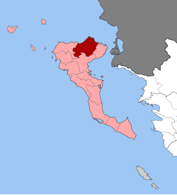
Thinali ( Greek Θινάλι ( n. Sg. )) Is a municipality on the Greek island of Corfu . Founded as the municipality of Thinali in 1989, it was merged in 2010 as one of 15 municipal districts to form the municipality of Kerkyra . This includes the entire island and the Diapontian Islands .
location
The municipality of Thinali is located in the north of the Ionian island of Corfu . It is dominated in the southeast and south by the Pantocrator , the highest mountain in Corfu. With 77.899 km² Thinali is the largest area of the municipality of Kerkyra . Neighboring parishes are Kassiopi in the east, Feakes in the south and Esperies in the west.
Administrative division
The municipality of Thinali ( Δήμος Θιναλίου Dímos Thinalíou ) was founded in 1989 from the merger of seven rural communities. The administrative seat was Acharavi . After the annexation of the rural community of Nymfes in 1994, the municipality was expanded to include the rural communities of Klimatia and Xanthates as part of the 1997 regional reform . As one of 15 municipal districts, Thinali was absorbed into the newly formed Kerkyra municipality in accordance with the 2010 administrative reform .
| City district / local community |
Greek name | code | Area (km²) | 2001 residents | Residents 2011 | Villages and settlements, uninhabited islands |
|---|---|---|---|---|---|---|
| Nymfes | Δημοτική Κοινότητα Νυμφών | 32010606 | 6.849 | 1,124 | 995 | Nymfes, Platonas |
| Agios Pandeleimonas | Τοπική Κοινότητα Αγίου Παντελεήμονα | 32010601 | 7.249 | 906 | 1207 | Agios Pandeleimonas, Acharavi, Fourni, Lazaratika, Priftiatika, Strongyli, Vrachleri |
| Episkepsi | Τοπική Κοινότητα Επισκέψεως | 32010602 | 8,074 | 579 | 537 | Episkepsi, Agios Stefanos |
| Klimatia | Τοπική Κοινότητα Κληματιάς | 32010603 | 7.375 | 510 | 289 | Klimatia, Episkopi, Kyprianades |
| Lavki | Τοπική Κοινότητα Λαυκίου | 32010604 | 5.275 | 407 | 229 | Lavki, Agios Martinos, Psachnia, Trimodi |
| Loutses | Τοπική Κοινότητα Λουτσών | 32010605 | 5.925 | 355 | 223 | Loutses, Anapaftiria, Apraos, Magarik |
| Xanthates | Τοπική Κοινότητα Ξανθάτων | 32010607 | 2.275 | 320 | 189 | Xanthates |
| Perithia | Τοπική Κοινότητα Περιθείας | 32010608 | 16,550 | 539 | 569 | Perithia , Agios Ilias, Vathy, Vasilika, Vouni, Karniaris, Krinia, Pelekito, Perouli, Pithos, Riliatika |
| Petalia | Τοπική Κοινότητα Πεταλείας | 32010609 | 13.627 | 193 | 209 | Petalia, Droseri, Eriva, Perama, Strinylas |
| Sfakera | Τοπική Κοινότητα Σφακερών | 32010610 | 4,700 | 579 | 788 | Sfakera, Roda |
| total | 320106 | 77.899 | 5512 | 5226 | ||
Individual evidence
- ↑ Results of the 2011 census at the National Statistical Service of Greece (ΕΛ.ΣΤΑΤ) (Excel document, 2.6 MB)
- ↑ Greek Law Gazette of June 30, 1989 (ΦΕΚ A 178 // June 30, 1989), p. 4319. PDF Online (Greek)
- ↑ Greek Law Gazette of August 30, 1994 (ΦΕΚ A 136 // 08/30/1994), Presidential Decree ΠΔ 245, p. 1651. PDF Online (Greek)
- ↑ Κεντρική Ένωση Δήμων και Κοινοτήτων Ελλάδας (ΚΕΔΚΕ) Ελληνική Εταιρία Τοπικής Ανάπτυξης και Αυτοδιοίκησης (ΕΕΤΑΑ) (ed.): Λεξικό Διοικητικών Μεταβολών των Δήμων και Κοινοτήτων (1912-2001). Volume 1 (Τόμος A, a – K), Athens 2002, ISBN 960-7509-47-1 , p. 377.
- ↑ Kallikratis Program, Law 3852/2010, «Νέα Αρχιτεκτονική της Αυτοδιοίκησης και της Αποκεντρωμένης ΔιοκεντρωμΠνης Διοίκησης - Πρόγραμημα άρτάτης τρτάτης. ΦΕΚ 87 A / 7.6.2010, Άρθρο 1. Σύσταση δήμων. P. 1789. PDF Online (Greek)

