Tikitiki
| Tikitiki | ||
| Geographical location | ||
|
|
||
| Coordinates | 37 ° 48 ′ S , 178 ° 25 ′ E | |
| Region ISO | NZ GIS | |
| Country |
|
|
| region | Gisborne | |
| District | Gisborne District | |
| Ward | Matakaoa Ward | |
| Residents | few | |
| height | 19 m | |
| Post Code | 4087 | |
| Telephone code | +64 (0) 6 | |
| Photography of the place | ||
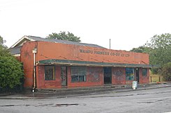
 Abandoned commercial building in Tikitiki |
||
Tikitiki is a small village in the Gisborne District on the North Island of New Zealand .
geography
The village is located about 102 km north-northeast of Gisborne between the Poroporo River and the Waiapu River , which flows into the Pacific Ocean about 6.5 km northeast . The East Cape is located around 17 km northeast of the village. The New Zealand State Highway 35 runs from the north, coming from Te Araroa , through the village and connects it further south with Tokomaru Bay and Tolaga Bay .
history
In Tikitiki there is a Māori Church, Saint Mary's Church , which was built in 1924 as a memorial to the soldiers who came from Iwi Ngāti Porou and who fell in World War I and was consecrated in 1926 . In the church there is a commemorative plaque and a reminder of the Māori politician Sir Apirana Ngata , on whose initiative the building of the church, using traditional Māori handicraft techniques , goes back.
Education
With the Tikitiki School, the settlement has a primary school with grades 1 to 6. In 2016, 18 students attended the school.
Individual evidence
- ↑ Topo250 maps . Land Information New Zealand , accessed September 3, 2017 .
- ↑ Monty Soutar : East Coast places - St Mary's church: exterior . In: Te Ara - the Encyclopedia of New Zealand . Ministry for Culture & Heritage , March 30, 2015, accessed November 8, 2016 .
- ^ Tikitiki School . Education Review Office , accessed September 3, 2017 .
