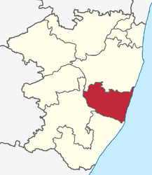
Tirukalukundram (Taluk)
| Taluk Tirukalukundram திருக்கழுகுன்றம் வட்டம் |
|
|---|---|

|
|
| State | Tamil Nadu |
| District : | Kanchipuram |
| Main town : | Tirukalukundram |
| Area : | 352.8 km² |
| Residents : | 196,807 (2011) |
| Population density : | 558 inhabitants / km² |
The Taluk Tirukalukundram ( Tamil : திருக்கழுகுன்றம் வட்டம் ; also Thirukazhukundram ) is a Taluk ( sub- district) of the Kanchipuram district in the Indian state of Tamil Nadu . The main town is the eponymous city of Tirukalukundram .
geography
The Taluk Tirukalukundram is located on the coast of the Bay of Bengal . It is bordered by the Taluks Cheyyur in the south, Maduranthakam in the southwest and Chengalpattu in the north. In the south and west, the Palar River borders the Taluk Tirukalukundram.
The Taluk Tirukalukundram is congruent with the block Tirukalukundram. Its area is 352.8 square kilometers.
population
According to the 2011 census, the Taluk Tirukalukundram has 196,807 inhabitants. 66.7 percent of these are classified as rural and 33.3 percent as urban populations. The population density is 558 inhabitants per square kilometer.
places
The following places belong to the Taluk Tirukalukundram:
Cities:
Villages:
Individual evidence
- ^ Census of India 2011: Administrative Atlas of India . (PDF; 31.7 MB)
- ↑ Map of the blocks of Kanchipuram district on the district website. ( Memento from November 4, 2012 in the Internet Archive )
- ↑ Kanchipuram District Statistical Handbook 2006: Area and Population. ( Memento of April 10, 2009 in the Internet Archive ) (PDF; 102 kB)
- ^ Census of India 2011: Provisional Population Totals - Tamil Nadu-Census 2011. Sub District (Taluk) Level. ( Memento from June 17, 2013 in the Internet Archive ) (PDF; 1.1 MB)
- ^ Census of India 2011: Villages / Towns Directory - 2011.