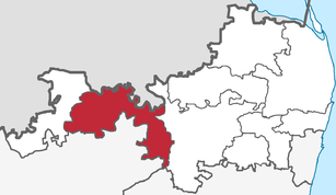
Tiruttani (Taluk)
| Taluk Tiruttani திருத்தணி வட்டம் |
|
|---|---|

|
|
| State | Tamil Nadu |
| District : | Tiruvallur |
| Main town : | Tiruttani |
| Area : | 448 km² |
| Residents : | 211,291 (2011) |
| Population density : | 472 inhabitants / km² |
The Taluk Tiruttani ( Tamil : திருத்தணி வட்டம் ) is a Taluk ( sub- district) of the Tiruvallur district in the Indian state of Tamil Nadu . The main town is the eponymous city of Tiruttani .
geography
The Taluk Tiruttani is located in the west of the Tiruvallur district in northern Tamil Nadu. It borders the Taluk Tiruvallur in the east, the Taluk Arakkonam of the Vellore district in the south, the Taluk Pallipattu in the west and the neighboring state of Andhra Pradesh in the north.
The Taluk Tiruttani is congruent with the blocks Tiruttani and Tiruvalangadu. Its area is 448 square kilometers.
history
During the British colonial era , the Taluk Tiruttani belonged initially to the North Arcot district and later to the Chittoor district of the Madras presidency, founded in 1911 . When, after Indian independence, the borders of the states were re-formed according to the language borders, the affiliation of Tiruttani became a matter of dispute. In 1953 the Taluk Tiruttani and the rest of the Chittoor district came to the state of Andhra , which was formed from the Telugu-speaking northern part of Madras , from which the state of Andhra Pradesh emerged in 1956 . Because of its predominantly Tamil population, the Taluk Tiruttani, together with the Taluk Pallipattu, was again added to the state of Madras (renamed Tamil Nadu in 1969) , which had meanwhile been reorganized according to the language borders of Tamil . The Taluk was incorporated into the Chengalpattu district, from whose northern part the Tiruvallur district emerged in 1997 .
population
According to the 2011 census, the Taluk Tiruttani has 211,291 inhabitants. 79 percent of the population lives in rural areas and 21 percent in cities. The population density is 472 inhabitants per square kilometer.
94 percent of the residents of Taluk Tiruttani are Hindus , 4 percent are Muslims and 2 percent are Christians . As in the whole of Tamil Nadu, the main language is Tamil , which according to the 2001 census is spoken by 74 percent of the population as their mother tongue. There is also a larger minority of speakers of Telugu , the language of the neighboring state of Andhra Pradesh, who make up 23 percent of the district's population. Urdu (2 percent) is partly widespread among Muslims .
Cities and villages
The following places belong to the Taluk Tiruttani:
Cities:
Villages:
Individual evidence
- ↑ Map of Taluks and Blocks of Tiruvallur District on the district's website. ( Memento of the original from December 11, 2015 in the Internet Archive ) Info: The archive link was inserted automatically and has not yet been checked. Please check the original and archive link according to the instructions and then remove this notice.
- ↑ Tiruvallur District Statistical Hand Book 2010-2011: Area and Population. ( Memento of the original from December 23, 2015 in the Internet Archive ) Info: The archive link was inserted automatically and has not yet been checked. Please check the original and archive link according to the instructions and then remove this notice. (PDF; 34 kB)
- ↑ Census of India 2011: Primary Census Abstract Data Tables: Thiruvallur.
- ^ Census of India 2011: C-1 Population By Religious Community. Tamil Nadu.
- ↑ Census of India 2001: C-15: Population by Mother Tongue (Tamil Nadu), accessed under Tabulations Plan of Census Year - 2001 .
- ^ Census of India 2011: Villages / Towns Directory - 2011.
literature
- The Imperial Gazetteer of India. Volume 23: Singhbhūm to Trashi-Chöd-Zong. New edition Clarendon Press, Oxford 1908, p. 397 , keyword: Tiruttani Tahsīl .