Tjørnuvík
|
||

|
||
| position | 62 ° 18 ' N , 7 ° 9' W | |
|
Resident rank |
67 (2011) 68 |
|
| Commune | Sunda communa | |
| Post Code | FO 445 | |
| Markatal | ||
|
Grammar dative (in / from ...) genitive (after ...) |
í / úr Tjørnuvík til Tjørnuvíkar |
|
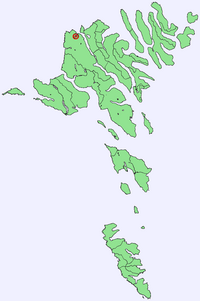
Tjørnuvík [ ˈtʃʰœdnʊvʊik ] ( Danish name : Tjørnevig ) is a place in the Faroe Islands in the far north of the main island Streymoy . The place is an important archaeological site of importance for Faroese history.
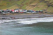
The small town is on the east coast of Streymoy. Tjørnuvík is known for its small sandy beach (rare in the Faroe Islands) and the view of the two natural monuments Risin and Kellingin .
The road system on the island ends in Tjørnuvík. Therefore there is no through traffic here. The place is nestled between steeply rising mountains, and the sun only shines here in the morning, because Tjørnuvík is only open to the east. A single-lane road leads along the steep coast, and there is also a regular bus service.
A demanding old path leads from Saksun over the mountains.
The village church was dismantled in 1857 and brought to Saksun via the route mentioned above. Tjørnuvík only got a new church in 1937, which is still in use today.
In 1956 the tomb of a woman from the 10th century was found here during archaeological surveys led by Sverri Dahl (first curator of the Faroese National Museum). It is one of the testimonies to the Scandinavian conquest of the Viking Age . (see Viking Age in the Faroe Islands )
Web links
- Folkakirkjan.fo - Tjørnuvíkar Kirkja (in Faroese about the church history of Tjørnuvík)
Individual evidence
- ↑ Sverri Dahl: Víkingaaldargröv í Tjørnuvík , bls. 153, 5. bók, Fróðskaparrit, Tórshavn 1956 (in Faroese)

