
Tjeldsund (strait)
| Tjeldsund | ||
|---|---|---|
 |
||
| Connects waters | Ofotfjord | |
| with water | Vågsfjord | |
| Separates land mass | Hinnøya | |
| of land mass | mainland Norway and Tjeldøya | |
| Data | ||
| Geographical location | 68 ° 35 '29 " N , 16 ° 31' 35" E | |
|
||
| bridges | Tjeldsund Bridge | |

The Tjeldsund ( Norwegian Tjeldsundet ) is a strait or a sound in northern Norway. The 50 km long strait is located in the northern part between the island of Hinnøya and the Norwegian mainland and between Hinnøya and the island of Tjeldøya in the southern part. The Tjeldsund has been an important waterway for over 1000 years and was well known and frequented in the Viking Age . The name is composed of Norwegian Tjeld ( German oystercatcher ) and sund .
The northern part is in Troms og Finnmark between the municipalities of Harstad and Tjeldsund , while the southern part is in Nordland between the municipalities of Tjeldsund and Lødingen . The southern approach to the strait begins in Lødingen by the Ofotfjord and the town of Harstad is at the northern end, where the strait flows into the Vågsfjord .
The 1007 m long Tjeldsund Bridge ( Norwegian Tjeldsundbrua ), which was opened in 1967 by King Olav V , connects Hinnøya with the mainland. The E10 , which is also called Kong Olav Vs vei here , runs over the bridge. The bridge is also part of the connection between Harstad and Harstad / Narvik Airport ( Norwegian Harstad / Narvik lufthamn, Evenes ).
gallery

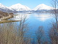
Southern part of the Tjeldsund; Looking east to the mountainous island of Tjeldøya

The Lavansfjord, a branch of the Tjeldsund in the municipality of Tjeldsund

Tjeldsund Bridge ( Norwegian Tjeldsund brua or Tjeldsund bru ) over the Tjeldsund
Look north on the Tjeldsund

.jpg)


Individual evidence
- ^ Tjeldsundet. In: Store norske leksikon. Retrieved January 28, 2013 (Norwegian).