Tongren (Huangnan)
| Tibetan name |
|---|
|
Tibetan script :
རེབ་ གོང ། རེ་ སྐོང ། རེབ་ སྐོང ། ཐུང་ རེན །
|
|
Wylie transliteration : reb gong, re skong, reb skong, thung ren
|
|
Official transcription of the PRCh : Rebgong
|
|
Other spellings: Repgong, Rebgong
|
| Chinese name |
|
Traditional :
同仁 縣 、 熱 貢
|
|
Simplified :
同仁 县 、 热 贡
|
|
Pinyin : Tóngrén Xiàn, Règòng
|

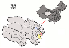
Location of Tongren (pink) in Huangnan (yellow)
Tongren County ( Rebgong ) is a county in the east of the Chinese province of Qinghai . It belongs to the administrative area of the Huangnan Autonomous District of the Tibetans . Tongren has an area of 3,465 km² and has a population of around 80,000 (2004). Its main town is the large community of Rongwo (隆 务 镇).
Administrative structure
At the community level, Tongren is made up of three major communities and eight communities . These are:
- Rongwo Municipality (Longwu 隆 务 镇 );
- Greater community Bao'an (Bao'an 保安镇 );
- Greater Dowa municipality ( མདོ་ བ་ / Duowa 多 哇 镇 );
- Loinqê municipality ( བློན་ ཆེ་ / Lancai 兰 采 乡 );
- Community Xopongxi ( ཞོ་ འཕོངས་ གཤིས་ / Shuangpengxi 双朋西乡 );
- Community Zainmo (Zhamao 扎毛乡 );
- Hornag municipality ( ཧོར་ ནག་ / Huangnaigai 黄乃 亥 乡 );
- Community Qukog ( ཆུ་ ཁོག་ / Qukuhu 曲库乎乡 );
- Nyaintog municipality ( གཉན་ ཐོག་ / Nianduhu 年 都 乎 乡 );
- Garzê municipality ( མགར་ རྩེ་ / Guashize 瓜 什 则 乡 );
- Community Gyaiwo ( རྒྱ་ བོ་ / Jiawu 加吾乡 ).
Ethnic breakdown of the population (2000)
At the 2000 census, Tongren had 77,040 residents.
| Name of the people | Residents | proportion of |
|---|---|---|
| Tibetans | 57,279 | 74.35% |
| Do | 7,991 | 10.37% |
| Han | 6,814 | 8.84% |
| Hui | 3,295 | 4.28% |
| Salar | 1,086 | 1.41% |
| Bonan | 285 | 0.37% |
| Mongols | 137 | 0.18% |
| Manju | 64 | 0.08% |
| Dongxiang | 35 | 0.05% |
| Uighurs | 10 | 0.01% |
| Lisu | 9 | 0.01% |
| Qiang | 9 | 0.01% |
| Zhuang | 6th | 0.01% |
| Others | 20th | 0.03% |
See also
literature
- T. Yangdon Dhondup: " Reb kong: Religion, History and Identity of a Sino-Tibetan borderland town (PDF; 501 kB)"
Individual evidence
- ^ A b Melvyn C. Goldstein, Matthew Kapstein: Buddhism in Contemporary Tibet. University of California Press 1998, p. 184.
Coordinates: 35 ° 25 ' N , 102 ° 5' E