Traisenberg
| Traisenberg | ||
|---|---|---|
|
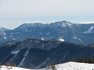
Stieglmauer (foreground), seen from the Tirolerkogel |
||
| height | 1230 m above sea level A. | |
| location | Lower Austria | |
| Mountains | Türnitz Alps | |
| Dominance | 3.8 km → Tirolerkogel | |
| Notch height | 193 m ↓ south of Törlstein | |
| Coordinates | 47 ° 51 '37 " N , 15 ° 29' 15" E | |
|
|
||
The Traisenberg is the geographical center of the Traisen valleys in southern Lower Austria . It is rarely used, but dominates the topography and the water flow of many spring streams thanks to its broad massif.
The massif and covers km² over 30 will (of the two main valleys of Traisen Türnitzer and wrong-Traisen ) and its tributaries surrounded almost completely, in the southwest of the Traisen mountain is a little road from Annaberg through the Pfarrtal the core Hofer Gscheid (982 m) and further bounded into the Unrecht-Traisental, separated in the northeast by the Traisenbergsattel from the St. Aegyder Bürgeralpe. The main summit Enzian reaches a height of 1230 m above sea level. A.
The slopes and summit regions are almost entirely forested; In the ridge and summit area there are also rock structures and rock walls. The mountain massif is only partially accessible via some forest roads; the isolated footpaths are hardly frequented by mountaineers. This situation contributes to the fact that the watercourses in the upper Traisen valleys are among the purest in Austria.
Administratively, the Traisenberg massif belongs to the Lilienfeld district and the market towns of Türnitz and St. Aegyd am Neuwalde .
summit
The peaks of the Traisenberg, from southeast to northwest:
- Karnermauer, 1176 m
- Castle wall, 1215 m
- Stiegl wall, 1224 m
- Gentian, 1230 m
- Sonnkogel, 1190 m
Surrounding peaks: Türnitzer Höger ( 1372 m ) and Tirolerkogel ( 1377 m ), Gippel ( 1699 m ) and Göller ( 1766 m )

