Ukinrek Maare
| Western Ukinrek Maar | ||
|---|---|---|

|
||
| The two maars (left the eastern maar, right the smaller western maar) with the volcano Mount Peulik in the background | ||
| Geographical location | Alaska (USA) | |
| Data | ||
| Coordinates | 57 ° 50 ′ 3 " N , 156 ° 31 ′ 28" W. | |
|
|
||
|
particularities |
Maar , formation and last eruption 1977 |
|

|
||
| Western Ukinrek Maar in 1995 | ||
| Eastern Ukinrek Maar | |
|---|---|

|
|
| Eastern Ukinrek Maar | |
| Geographical location | Alaska (USA) |
| Data | |
| Coordinates | 57 ° 50 ′ 2 " N , 156 ° 30 ′ 53" W. |
| length | 300 m |
| width | 250 m |
|
particularities |
Maar , formation and last eruption 1977 |

|
|
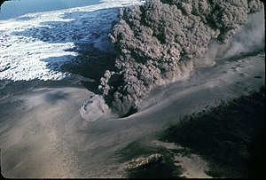
| Eruption of the eastern Ukinrek maar in 1977 | |
The Ukinrek Maars are a pair of maars in the Becharof National Wildlife Refuge , Alaska , Aleutian Range on the Alaska Peninsula . They were formed by phreatomagmatic explosions .
description
The maars lie on a low, less than a hundred meters high and 4 km long ridge that rises above the lowlands bordering the Bering Sea . The maars are 2 km south of Becharof Lake and 12.5 km northwest of Mount Peulik volcano .
Both maars are filled with water. The western, older maar ( West Maar ) formed at the northwest end of the ridge. It has an elliptical shape and is 105 × 170 m in size with a depth of 35 m. The younger maar ( East Maar ) is 600 m further east and is a little deeper. It is round in shape, 300 m tall and about 70 m deep. A lava dome has formed in its center, rising around 49 m from the lake bed.
Emergence
The maars formed during a ten-day eruption in 1977. The resulting tuff fans ( base surges ) were mainly ejected to the northwest. The extracted material had a volume of about 2.6 × 10 7 m 3 , it was of olivine - basaltic composition.
The eruption began on March 30, 1977. Apparently, rising magma hit groundwater contained in a tuff layer sandwiched between impermeable glacial deposits. The western maar was the first to form under the explosive discharge of steam and volcanic ash that rose up to 6500 m. After a few days, the activity shifted to a new crater, the eastern maar. For a few days, violent explosions created an ash cloud of up to 4,000 m in height, base surges and the ejection of boulders that flew up to 600 m. The emitted ash was observed as light ash rain at a distance of 160 km to the north. Towards the end of the eruption, lava fountains became visible in the East Maar and a lava dome formed. On April 10, 1977, steam rising from the lava dome was the only evidence of the eruption, while the maar cauldron filled with water.
environment
The volcanic activity on the 2500 km long Aleutian Arc can be traced back to the subduction of the Pacific Plate under the North American Plate at the 7000 m deep Aleutian Trench . The western part up to 165 ° western latitude is a classic island arc , while the eastern part is influenced by the continental margin of the North American plate. Over 40 volcanoes have been active in this area since 1700.
The location of the Ukinrek maars is believed to be linked to the intersection between a local fault ( Bruin Bay Fault ) and other regional structures. No volcanic structures were known in the area prior to the eruption. The next volcanic field is the lava domes of the Gas Rocks on the shores of Becharof Lake about three kilometers north of the Ukinrek Maare, which mined rocks of Dacite composition about 2,900 years ago .
literature
- Ukinrek-Maare in the Global Volcanism Program of the Smithsonian Institution (English)
- TP Miller, RG McGimsey, DH Richter, JR Riehle, CJ Nye, ME Yount and JA Dumoulin: Catalog of the historically active volcanoes of Alaska. US Geological Survey Open-File Report OF 98-0582, 104 pp., 1998. Online version
