União da Serra
| Município de União da Serra União da Serra |
|||
|---|---|---|---|
|
|
|||
| Coordinates | 28 ° 45 ′ S , 52 ° 1 ′ W | ||
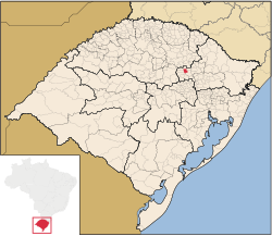
 Location of the municipality in the state of Rio Grande do Sul Location of the municipality in the state of Rio Grande do Sul
|
|||
| Symbols | |||
|
|||
| founding | 20th March 1992 (age 28) | ||
| Basic data | |||
| Country | Brazil | ||
| State | Rio Grande do Sul | ||
| ISO 3166-2 | BR-RS | ||
| structure | 3 districts | ||
| height | 520 m | ||
| climate | subtropical, Cfa | ||
| surface | 131 km² | ||
| Residents | 1487 (2010) | ||
| density | 11.4 Ew. / km² | ||
| estimate | 1154 (July 1, 2019) | ||
| Parish code | IBGE : 4322350 | ||
| Post Code | 99215-000 | ||
| Telephone code | (+55) 54 | ||
| Time zone | UTC −3 | ||
| Website | uniaodaserra.rs (Brazilian Portuguese) | ||
| politics | |||
| City Prefect | Léo Paulo Cendron (2017-2020) | ||
| Political party | PTB | ||
| Culture | |||
| City festival | March 20 (founding day) | ||
| economy | |||
| GDP | 55,311 thousand. R $ 39,706 R $ per capita (2016) |
||
| HDI | 0.733 (high) (2010) | ||
União da Serra , officially Portuguese Município de União da Serra , is a small political municipality in the Brazilian state of Rio Grande do Sul . It was only spun off from Guaporé in 1992 and is 208 kilometers by road from the capital, Porto Alegre . The population was estimated to be declining on July 1, 2019 to 1154 inhabitants, who live on a community area of around 131 km² and are called União-Serrenser. The population is over 99% Roman Catholic and the community has the title Capital Nacional da Fé Católica (National Capital of the Catholic Faith).
geography
Surrounding communities are Guaporé, Montauri , Arvorezinha , Itapuca and Serafina Corrêa .
climate
The city has a tropical, temperate and warm climate, Cfa according to the Köppen and Geiger climate classification . The average temperature is 18.5.6 ° C. The average rainfall is 1600 mm per year.
population
Of the 1487 inhabitants in 2010 according to the census, 1207 lived in rural areas and only 280 in urban areas.
| year | Residents |
| 1991 | 2,628 |
| 2000 | 1,908 |
| 2010 | 1,487 |
| 2019 | 1,154 |
 |
|
União da Serra had an illiteracy rate of 15.7% in 1991 , which had already fallen to 5.9% in the 2010 census.
| Illiteracy rate | ||||
|---|---|---|---|---|
| year | percent | |||
| 1991 | 15.67 | |||
| 2000 | 9.50 | |||
| 2010 | 5.89 | |||
Ethnic groups according to the statistical classification of the IBGE (as of 2010 with 1487 inhabitants):
| group | proportion of | annotation |
|---|---|---|
| Brancos | 1,435 | (Whites, descendants of Europeans ) |
| Pardos (mixed race) | 38 | ( Mulatto , mestizo ) |
| Pretus | 10 | ( Blacks ) |
| Amarelos | 4th | (Asians) |
| Indigenous people | - | (indigenous population) |
| without specification | - |
Web links
Individual evidence
- ↑ a b União da Serra climate: Climate table, Climate chart for União da Serra. In: de.climate-data.org. Retrieved October 19, 2019 .
- ↑ a b c União da Serra - Panorama. In: cidades.ibge.gov.br. IBGE , accessed October 19, 2019 (Brazilian Portuguese).
- ↑ Paulo 14 (Prefeito). In: todapolitica.com. Eleições 2016, accessed October 19, 2019 (Brazilian Portuguese).
- ^ Atlas do Desenvolvimento Humano do Brasil: União da Serra . Retrieved October 19, 2019 (Brazilian Portuguese).
- ↑ Síntese the Informações de União da Serra (RS). Informações do Brasil, accessed January 11, 2017 (Brazilian Portuguese).


