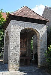
Lower suburb (Volkach)
The lower suburb is a historical settlement core of the Lower Franconian town of Volkach in the district of Kitzingen . The brickworks and the fishing settlement were to be found in the lower suburb . Today the suburb is classified as a desert .
Geographical location
The lower suburb is northwest of the Volkach old town , the former settlement is built over. To the north is the Volkach building area Am Sambühl , while to the east the Volkachbach runs along the Volkach city fortifications . In the southeast the old town begins with the Gaibacher Tor . To the south is the Hindenburgpark with the wine festival area. The driver road runs in a north-westerly direction and together with the Gaibacher road forms the center of the area.
The former suburb is classified as a desert and is located in the corridor Kalte Höfe.
history
The area north of the Volkach town center was already permanently settled in the Neolithic Age. People of the linear ceramic culture lived here , they were later replaced by the Hallstatt people . The area remained inhabited during the Roman Empire. With the Frankish colonization in the Main loop region north of the up-and-coming Volkach settlement, the forests were cleared and vineyards were created.
In the Middle Ages , a fish market was established on the Volkachbach , around which fishermen soon settled. The brook was the only free fishing water for the residents. The people of Volkach also used the nearby brook as a drive for mills, and the bridge mill was built near the fish market , which was to form another center of the Lower Suburb. The odorous work of tanning was also carried out here, although the tanners themselves lived in the city.
With the rise of the original parish church Maria im Weingarten to a place of pilgrimage, the pilgrims to the Volkach old town also moved through the lower suburbs. The most obvious symbol of this religious significance is still the wayside shrine from the 15th century . However, he was later moved closer to the city. On the old pilgrimage route were the brickworks and the Volkach clay pit, where materials for building houses were extracted.
Originally, the settlement was not separated from the core city; the unity of the two town centers was only dissolved when the Volkach city fortifications were built around 1300. The inhabitants of the lower suburb, unlike the people of the core city, were repeatedly affected by sometimes severe floods of the Main, so that a gradual decline began. Around 1500 the fish market was relocated to the town hall , but the fishermen continued to settle by the stream.
The end of the medieval Lower Suburb came with the Thirty Years' War . The many migrations of foreign troops and the introduced epidemics led to a population decline in Volkach. The unprotected lower suburb was also easy to occupy, so that in 1698 a total of 20 parcels were deserted. At that time only the brickworks, the bridge mill, three houses and three workshops existed in the suburbs.
In the 17th century, the remaining residents moved to the core city of Volkach and the lower suburb was finally abandoned. Instead, the Upper Suburb , already established as a trading center, combined the core local elements. It was not until the 18th century that new houses were built on the abandoned area. Fruit and vegetables were later grown here. After the Second World War , the city grew up to the pilgrimage church. The underground remains of the suburb are listed as a ground monument .
See also
literature
- Gerhard Egert: The urban centers of the city - A contribution to the historical topography of Volkach . In: Ute Feuerbach (Ed.): Our Main Loop. 1978-1992 . Volkach 2008. pp. 337-339.
- Gerhard Egert: City and Parish Volkach am Main (A contribution to the city history of Franconia). Part I. The urban territory from the beginnings to the end of the Old Kingdom in 1803 . Würzburg and Volkach 1964.
- Hans-Eckhard Lindemann: Historic town centers in Main Franconia. History - structure - development . Munich 1989.
- Günther Schmitt: House chronicle of the city of Volkach as a mirror of the bourgeoisie. From the end of the 17th century until today (= Volkacher Hefte vol. 19) . Volkach 2017.
Web links
Individual evidence
- ^ Gerhard Egert: City and parish Volkach am Main . P. 76.
- ^ Günther Schmitt: House chronicle of the city of Volkach . P. 132.
- ↑ Gerhard Egert: The settlement centers of the city. P. 338.
- ^ Lindemann, Hans-Eckhard: Historic town centers in Mainfranken . P. 44.
- ^ Egert, Gerhard: City and parish Volkach am Main . P. 75.
Coordinates: 49 ° 52 '5.4 " N , 10 ° 13" 23.3 " E

