Thisleitenbach
|
This Leitenbach Dießen Leitenbach |
||
|
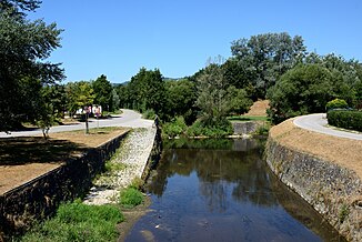
The Theseleitenbach as a collecting channel near Plesching |
||
| Data | ||
| location | Mühlviertel , Upper Austria | |
| River system | Danube | |
| Drain over | Danube → Black Sea | |
| origin | on the southern slope of the Lichtenberg (municipality of Lichtenberg ) 48 ° 22 ′ 41 ″ N , 14 ° 15 ′ 7 ″ E |
|
| Source height | approx. 800 m above sea level A. | |
| muzzle | with downdrafts into the Danube coordinates: 48 ° 15 ′ 25 ″ N , 14 ° 25 ′ 26 ″ E 48 ° 15 ′ 25 ″ N , 14 ° 25 ′ 26 ″ E |
|
| Mouth height | approx. 240 m above sea level A. | |
| Height difference | approx. 560 m | |
| Bottom slope | approx. 60 ‰ | |
| length | approx 9.4 km | |
| Catchment area | 10.5 km² | |
| Left tributaries | Harbach, Höllmühlbach , Haselbach, Katzbach, Reichenbach | |
| Big cities | Linz | |
The Theseleitenbach (also Dießenleitenbach ) is a 9.4 km long left tributary of the Danube in the Mühlviertel in Upper Austria . In Linz it forms the so-called Urfahr collecting channel .
Run and landscape
Thisleitenbach rises on the southern slope of the Lichtenberg in the municipality of Lichtenberg . It flows approximately from the municipal boundary to Linz along the Dießenleitenweg, then through the village of Bachl and further along the Hauserstraße. It then crosses under Leonfeldener Straße and flows through the Urfahr urn grove , where the Harbach flows into; then continue along Linzer Strasse under Freistädter Strasse and the Mühlkreis Autobahn . This is where the confluence with the Danube was located until the Abhaben power plant was built. Due to the rising water level of the Danube, it was artificially diverted and created a collecting channel that runs along the Danube dam. From the crossing under the motorway, the habenleitenbach is therefore usually referred to as the “Urfahrer collecting channel”, as all the Mühlviertel brooks ( Haselbach , Katzbach, etc.) flow into it in the further course . It flows further along the Pleschinger See and the B3 through the Au near Steyregg and Abhaben, where the Reichenbach also joins. The mouth of the Theseleitenbach or the collecting channel is located in Abhaben shortly after the Abzüge power plant, where the brook joins the Danube or an oxbow river of the same.
A popular hiking trail runs along the brook from Linz over the river These lines to the Gis .
Catchment area and water supply
The Theseleitenbach drains a catchment area of 10.5 km².
Individual evidence
- ↑ a b c Digital Upper Austrian Room Information System (DORIS)
- ↑ Friedrich Schwarz: The Dießenleitenbach. Portrait of a Mühlviertel Bach ecosystem. Natural history station Linz.
