Höllmühlbach
| Höllmühlbach | ||
|
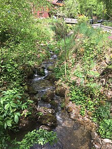
Höllmühlbach, view from the bridge of Linzer Straße in east direction to Steg |
||
| Data | ||
| location | Mühlviertel , Upper Austria | |
| River system | Danube | |
| Drain over | Danube → Black Sea | |
| source | on the eastern slope of the G sharp 48 ° 22 ′ 41 ″ N , 14 ° 15 ′ 34 ″ E |
|
| Source height | approx. 800 m above sea level A. | |
| muzzle | in Linz -Steg in the Urfahr collecting channel Coordinates: 48 ° 19 ′ 32 ″ N , 14 ° 18 ′ 16 ″ E 48 ° 19 ′ 32 ″ N , 14 ° 18 ′ 16 ″ E |
|
| Mouth height | approx. 260 m above sea level A. | |
| Height difference | approx. 540 m | |
| Bottom slope | approx. 64 ‰ | |
| length | 8.5 km | |
| Catchment area | 8.1 km² | |
| Big cities | Linz | |
The Höllmühlbach (also Höhlmühlbach ) is a left tributary of the Urfahr collecting channel formed by the Theseleitenbach - until it was regulated by the construction of the Abzüge der Donau power plant - in Upper Austria . The name refers to the former Höllmühle (Koglhörmühle) located on the upper reaches of the stream, to which the Höllmühlstraße led.
course
The Höllmühlbach rises on the eastern slope of the Lichtenberg in the municipality of the same name . It flows in a south-easterly direction and reaches the Linz city limits at the Steinbockweg . Then it flows parallel to Gründbergstraße, Nußbaumstraße On Gründberghof and crosses in Gründberg the Leonfeldener road . It continues to flow to Linzer Strasse and on to Steg, where it crosses under Freistädter Strasse and then the Mühlkreis Autobahn . Immediately afterwards it flows into the Urfahr collecting channel, which is formed by the Theseleitenbach. Around here was the confluence with the Danube, the level of which rose due to the construction of the Abzüge power plant, so that a collecting channel was created, which flows into the Danube below the power plant in downwinds.
While the upper course of the Höllmühlbach shows natural torrent characteristics, the lower course in the Linz city area is heavily regulated.
Catchment area
The upper reaches of the Höllmühlbach lies in the area of the Moldanubic of the Bohemian Mass with sediment cover. The mountain-forming units are migmatite , pearl gneiss and coarse-grain gneiss . The lower reaches lie in the molasse zone with marl, sand, gravel and lime.
The soils of the catchment area consist predominantly of lime-free rock-brown soil and are dry to moderately dry due to the moderate water storage capacity and high permeability.
history
The Celtic oppidum of Gründberg was created on the Gründberg plateau, which was protected by the two steeply sloping flanks to the Höllmühlbach in the west and to the Haselbach in the east.
In the 19th century, due to the lime-poor water of the Höllmühlbach, several laundries settled there, whose customers were mainly the citizens of Linz.
Around 1970 the lower course of the Höllmühlbach was heavily regulated over a length of approx. 3 km in the course of the torrent control and provided with a waterproof bed.
literature
- Georg Angelmaier: Precipitation-runoff modeling and 2D simulation at Höllmühlbach in Linz with investigation of the effects of the heavy settlement. Diploma thesis BOKU Vienna, 2010, 84 pages ( PDF on boku.ac.at).
- Erich Kainz: The Höllmühlbach in terms of fishing. In: Natural History Yearbook of the City of Linz. Linz 1984, pp. 195-213 ( PDF on ZOBODAT ).
- Friedrich Schwarz, Christiane Höller: Up to the “G sharp” - a nature hike to the climax in the Linz area. In: ÖKO.L magazine for ecology, nature and environmental protection. Linz 2011, pp. 17–27 ( PDF on ZOBODAT , natural history hike through the Gründberg district of Linz along the Höllmühlbach up to the Giselawarte).
Web links
- Sabine Neuweg, Alois Peham: City walks to St. Magdalena. In: nachrichten.at. December 10, 2010, accessed on April 30, 2020 (the Höllmühlbach near the city limits).
- Höllmühlbach , linzwiki.at
Individual evidence
- ↑ Kainz 1984, p. 106.
- ↑ according to the Digital Upper Austrian Room Information System (DORIS).
- ↑ a b Ludwig Benesch: Pictures from the archaeological surroundings of Linz. In: 69th annual report of the Francisco-Carolinum Museum. Linz 1911, pp. 184-186 ( PDF on ZOBODAT ).
- ↑ Hertha Schober-Awecker : The Nonnberg Office “enhalb der Donau”. In: Yearbook of the City of Linz 1952. Linz 1953, pp. 351 and 369 ( online (PDF) in the forum OoeGeschichte.at).
- ↑ Angelmaier 2010, p. 3.
- ↑ eBOD - digital soil map. In: bodenkarte.at. Accessed on May 2, 2020 (map control: "Bodenformen mit Profilstellen").
- ↑ Angelmaier 2010, p. 1.

