
Oppidum von Gründberg

The Gründberg oppidum is a late Latène Age Celtic hilltop settlement north of the Danube in Linz in Upper Austria . This settlement was a base of a since prehistoric times used traffic route , the Alpine foothills across the Mühlviertel with the Vltava and the settlement of Třísov in Dívčí Kámen in Bohemia joined by the shortest route.
location
The oppidum lies on the Gründberg , a ridge of the Bohemian Massif that runs from north to south . The hillside settlement was 1.5 km long, up to 400 meters wide and had a size of a good 50 hectares and was protected by natural precipices in the west ( Höllmühlbach gorge ), south and east ( Haselgraben ), in the flat north there was a double wall fortification. The north of the two walls had a typical Celtic pincer gate , the structure of which is still visible in the ground formation.
Neighboring settlements in the south-east were the Wallburg on the Luftenberg and in the south-west the two Celtic hilltop settlements on the Freinberg and the Kürnberg as well as the large settlement in Hörsching-Neubau .
history
The oppidum was located on the shortest connection from the Danube region to the Moldau and the Celtic settlements located there in what is now the Czech Republic. The court names Unterburger (in the southern part of the settlement) and Oberburger (in the northern part) are reminiscent of the old, Celtic fortifications. In the Middle Ages led a variant of Linz climbing mentioned salt trade route along the old path through the site of the former oppidum.
The system was first described topographically in 1911 by Ludwig Benesch, he also made an overview plan. The first datable finds were made in 1932 when a weekend house was being built. After the finds in the years 1932–1934, the first targeted excavations were carried out in autumn 1937. Extensive archaeological investigations took place over a period of five years from 1994 to 1998.
Ramparts
The south wall divides the Celtic settlement area into roughly two equal parts. The average base width of the south wall is about 10 meters, its height in the north about 3.5 meters and in the south 1.5 meters.
The north wall is a little lower and narrower than the south wall. At the eastern end, the north wall leaves a six-meter-wide gate free by two 12-meter-long flanks drawn inwards with a distance of about six meters.
Finds
In 1997, four iron depots were excavated in the embankment of the southern wall. These depots were located directly behind a 3 m high blind wall and are at regular intervals of almost 3 meters apart. The location and structural conditions suggest a construction sacrifice . In the first depot there were 16 objects with a total weight of around 20 kg. In the second depot there were 12 objects that weighed almost 10 kg. The third depot consisted of 13 objects with a total weight of 21 kg. The fourth depot only contained two bar fragments weighing more than 10 kg.
The 43 found objects, some of high quality steel with a total weight of over 60 kg, consisted of tools (a hook wrench , hatchets, variously shaped forge hammers, anvils ), kitchen utensils (roasting spit, meat fork, ash shovel, boiler fragments, boiler hooks), weapons (two swords, skewers , a trident ) and car fittings (wheel hubs, two wheel tires). The two swords are dated as older objects from the find, the other utensils are from the late Latène period. All finds show signs of use, but most of them are still usable. Carpenters, joiners, carpenters, wagons and blacksmiths are represented by their tools.
The fragment of a speckled plate for casting flintlets (coin blanks) could indicate a mint workshop in the settlement. Images of the iron finds from Gründberg as well as a speckled plate (from Titelberg in Luxembourg as an example) are in the illustrated book “Celts. Images of their culture ” .
photos

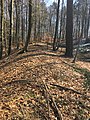
Gründberg-Südwall seen from the north - position in the zone between the north and south walls

Gründberg-Südwall with the excavation section from 1997
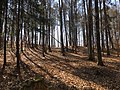
Gründberg-Nordwall

Pincer remains seen from inside the former settlement
Pincer remains seen from outside

View from the end of the north wall in north direction

View from the end of the north wall in south direction with the steep slope to the Haselgraben


See also
literature
- Erwin M. Ruprechtsberger, Otto Helmut Urban (scientific director): From the Celtic treasure to the early Linze. Accompanying volume for the exhibition “From the Celtic Treasure to the Early Linze” in the NORDICO City Museum Linz 8.2.-20.5.2013. Linz 2013, ISBN 978-3-85484-442-6 , 161 pages.
- Christine Ertel, Otto Helmut Urban , Erwin M. Ruprechtsberger : Celtic iron depot finds from Gründberg. In: Archeology of Austria. 8/2, Vienna 1998, p. 34 f.
- Christine Ertel, Otto Helmut Urban, Erwin M. Ruprechtsberger: A new late Celtic fastening technique. Results of the excavations on the Gründberg near Linz 1998. In: Archeology Austria. 9/2, Vienna 1998, p. 16 ff.
- Otto Helmut Urban, Erwin M. Ruprechtsberger: La site fortifié du Gründberg. In: Forgerons et Ferailleurs, fer et savoire-faire à l'époque celtique, Bibracte, Musée de la civilization celtique, Glux-en-Glenne, 2003, p. 16 ff.
- Ludwig Benesch: Pictures from the archaeological environment of Linz. In: 69th annual report of the Francisco-Carolinum Museum. Linz 1911, pp. 184–188 (entire article pp. 153–200, PDF on ZOBODAT ).
- Leonhard Franz, Franz Stroh: The Celtic settlement on the Gründberg. In: Yearbook of the Upper Austrian Museum Association. Volume 89, Linz 1940, pp. 215-238 ( PDF on ZOBODAT ).
- Otto Helmut Urban: The long way to history: the prehistory of Austria. Ueberreuter, Vienna 2000, ISBN 978-3-800-03773-5 .
- Susanne Sievers , Otto Helmut Urban, Peter C. Ramsl: Lexicon for Celtic Archeology. A – K and L – Z. Announcements of the prehistoric commission in the publishing house of the Austrian Academy of Sciences , Vienna 2012, ISBN 978-3-7001-6765-5 , p. 700 f.
Web links
- Bibliography on Gründberg kelt in the forum OoeGeschichte.at
Individual evidence
- ↑ Stroh 1940, p. 218.
- ↑ a b c Benesch 1911, p. 185 (with site plan).
- ↑ a b c Benesch 1911, p. 186.
- ↑ Stroh 1940, pp. 225f.
- ↑ a b c Stroh 1940, p. 220 (detailed description of the first finds on p. 229–232).
- ↑ Stroh 1940, p. 217.
- ^ A b c Otto Helmut Urban, Erwin M. Ruprechtsberger: Der Gründberg. In: Berge, Heile, Keltenschatz. Exhibition catalog. (= Linzer Archäologische Forschungen. Volume 27), Linz 1998, p. 61, entire article, p. 59–63; also Ruprechtsberger 2013, p. 14f.
- ↑ Stefan Moser: The Latène period settlement of Neubau near Traun - new finds of Celtic planar forms from Upper Austria. In: Yearbook of the Upper Austrian Museum Association. Bank 146, 1, Linz 2002, pp. 110–112 (exact sketch of the speckled plate on p. 111), entire article pp. 97–128, PDF on ZOBODAT
- ↑ Helmut Birkhan : Celts. Images of their culture. Publishing house of the Austrian Academy of Sciences, Vienna 1999, ISBN 3-7001-2814-2 , p. 344, images 625, 627.
Coordinates: 48 ° 20'26.3 " N , 14 ° 16'48.9" E