Gründberg (mountain in Linz)
| Gründberg | ||
|---|---|---|
|
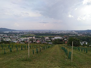
View from the Gründberg hill to the south of Linz |
||
| height | 374 m above sea level A. | |
| location | Upper Austria , Austria | |
| Coordinates | 48 ° 20 '22 " N , 14 ° 17' 14" E | |
|
|
||
| Normal way | Hike | |
The Gründberg is a ridge running from north to south in the urban area of the Upper Austrian capital Linz . The southernmost elevation is the 374 m high Gründberg hill, from which one has a good overview of Linz-Urfahr .
Surname
The Gründberg was first mentioned as Grinperg and Grimperg in 1405 in the land register of the Benedictine Abbey of Nonnberg .
location
Geologically , the Gründberg is an offshoot of the Mühlviertel hill country and thus belongs to the Bohemian Massif , a rump mountain range that extends from the Czech Republic to the neighboring areas of Austria , Germany and Poland .
The Gründberg with its steeply sloping flanks rises between the Haselgraben in the east and the Höllmühlbach in the west. The area covers around two thirds of the area of the Gründberg district of the same name . The municipality of Lichtenberg is located northwest of the Gründberg .
In the wooded area of the Gründberg there are several elevations (including 564 m and 536 m high), but the most striking is the only 374 m high, treeless Gründberg hill, which the locals often shorten as “Gründberg”. On the slope of the Gründberg hill are the two Swedish settlements built in 1955 , which in turn are parts of the eastern and western Gründbergsiedlung, which are separated by the hollow road of Höllmühlstraße.
history
The oldest finds on Gründberg date from the late Neolithic and the late Bronze Age .
The Oppidum of Gründberg was a spätlatènezeitliche Celtic hillfort and base one since prehistoric times used thoroughfare connecting the two valleys of the Danube and the Vltava joined by the shortest route. The striking south wall between the large green areas of the courtyards of the Unterburgers and Oberburgers can be seen very clearly. The former north wall runs through the forest north of the Oberburger and ends in front of the edge of the Haselgraben with a Celtic pincer gate that can still be seen in the area .
The ancient mule tracks were used in the Middle Ages for the salt trade along the so-called Linzer Steig .
In 1107 the Archbishop of Salzburg, Konrad I von Abenberg, confirmed ownership of the Nonnberg convent west of the Haselbach, i.e. the Gründberg. The oldest preserved land register of the Nonnberg monastery from 1332 names eight fiefs, two farms and a mill.
In the lower part of the Gründberg was the Burggern estate, first mentioned in 1412 as the Purkchgeren , which also took its name from the Celtic "castle". The terms Burggeher and finally Gründberghof were later used for this square, which was torn down in stages in the 20th century. The name was then transferred to the neighboring Gründberghof inn , which was in operation until 2002.
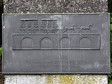
From 1832 to 1872 the horse-drawn railway Budweis – Linz – Gmunden ran at the foot of the Gründberg, with the Haselbach being crossed west of St. Magdalena . With the switch to steam operation in 1873, another route was chosen that no longer led through the Haselgraben.
The Gründberg chapel was built around 1900 and offers a beautiful view of the city.
On May 31, 1919, the Gründberg area was incorporated into the formerly independent municipality of Pöstlingberg, first to Urfahr and the next day to Linz.
After the flood disaster in 1954 , a total of 50 houses were built on two slope areas of the Gründberg with the help of Swedish donations, which were soon called "Swedish settlement".
In 1991 the artist Rudolf Leitner-Gründberg installed the temporary monument Die Krone am Gründberg on the Gründberg hill .
Attractions
- Parish Church of St. Mark
- Of the original, approximately 1.3 km long horse-drawn railway line along the Gründberg, only the western abutment of the large, four-arched stone bridge over the Haselgraben can be clearly seen. At this point on the edge of Leonfeldener Strasse is the horse-drawn railway monument with the following inscription:
"1832–1872 THE HORSE-RAILWAY LINZ-BUDWEIS CROSSED THE HASELGRABEN"
leisure
The paths to the “Gis” attract hikers and mountain bikers alike.
The rounded, unobstructed summit of the Gründberg hill was a popular area for kite flying until the vineyard was established in 2018 .
literature
- Hertha Schober-Awecker : The Nonnberg Office “enhalb der Donau”. In: Yearbook of the City of Linz 1952. Linz 1953, pp. 345–380 ( online (PDF) in the forum OoeGeschichte.at).
- Franz Pfeffer : Haselgrabenstrasse in the city of Linz. In: Historisches Jahrbuch der Stadt Linz 1960. Linz 1960, pp. 197–242 ( pp. 197–230 (PDF) in the forum OoeGeschichte.at, pp. 231–242 and tables I – XII (PDF) in the forum OoeGeschichte.at ).
Web links
- Bibliography on Gründberg in the forum OoeGeschichte.at
References and comments
- ^ A b Leonhard Franz, Franz Stroh: The Celtic settlement on the Gründberg. In: Yearbook of the Upper Austrian Museum Association. Volume 89, Linz 1940, p. 218 (entire article p. 215-238, PDF on ZOBODAT ).
- ↑ Otto Helmut Urban : Celtic hill settlements of the end of the Iron Age. In: Erwin M. Ruprechtsberger , Otto Helmut Urban (scientific director): From the Celtic treasure to the early Linze. Accompanying volume to the exhibition “From the Celtic Treasure to the Early Linze” in the NORDICO City Museum Linz 8.2.-20.5.2013 (= Linz Archaeological Research. Volume 43). Linz 2013, ISBN 978-3-85484-442-6 , p. 56.
- ↑ Schober-Awecker 1953, p. 348.
- ↑ Schober-Awecker 1953, p. 349 (sketch p. 353).
- ↑ Pfeffer 1960, p. 202 (the second part of the name "Gern" denoted a piece of terrain that tapered to a point in the Middle Ages).
- ↑ a b Pfeffer 1960, panel XI.
- ^ Oskar Dohle: Urfahr - 80 years near Linz (1919-1999). In: Yearbook of the City of Linz 1997. Linz 1999, p. 336 (entire article p. 291–352, online (PDF) in the forum OoeGeschichte.at).


