Lake Urmia
| Lake Urmia | ||
|---|---|---|

|
||
| Parts of the bridge that crosses the lake (2007). | ||
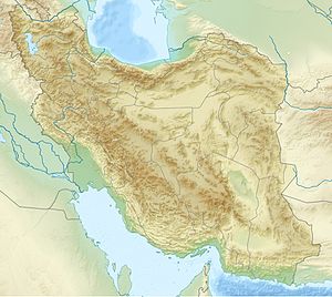
| Geographical location | East Azerbaijan , West Azerbaijan (Iran) | |
| Tributaries | Zarrineh | |
| Drain | none | |
| Location close to the shore | Urmia | |
| Data | ||
| Coordinates | 37 ° 42 ′ N , 45 ° 19 ′ E | |
|
|
||
| Altitude above sea level | 1280 m | |
| surface | 5 470 km² | |
| Maximum depth | 16 m | |
The Urmia Lake ( Persian درياچهٔ اروميه, DMG Daryāče-ye Orūmīye ; Middle Persian Čēčast ; Azerbaijani : Urmiye Gölü; Kurdish : Gola Urmiyê), at the time of the Pahlavi dynasty, Lake Rezaiye after Reza Shah , is the largest inland lake in Iran . The town of Urmia is located on the lake . Their name is derived from the Syrian-Aramaic words ur for "city" and mia for "water" and means "city on the water".
description
Until a few years ago, the lake was 140 km long, 55 km wide and had an area of 5470 km², so it was ten times larger than Lake Constance . Its average depth was only around 7 m and its maximum depth was 16 m. Its water level was 1280 meters above sea level. The salt content of the lake is up to 30%, which roughly corresponds to the salt content of the Dead Sea . Measurements from 1999 show a salinity of 21 to 23%. It therefore offers almost no higher animal and plant species a habitat. However, the high salinity defy brine shrimp . The lake has no drain and forms - similar to Lake Van in Turkey - a huge steppe lake . Salt deposits are often found on its banks. There are 102 islands in the lake. The lake drains an area of 51,000 km². The largest tributary is the Zarrine-Rūd, which flows into the lake in the south, followed by the Aji Chay, which flows into the eastern part. There are also 13 larger tributaries and other streams. On average, the lake absorbs 6.9 km³ of water per year. It is one of the endorheic waters , so it is not drained into a sea.
Impending salinization and rescue efforts
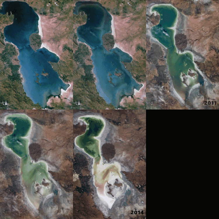
Due to the water crisis in Iran in the last few decades due to climatic and geographical conditions, but also due to human causes, there is a change in the mini-climate. Due to the damming of the tributaries, the water level has continuously decreased over the past decades. In 2014 the surface of the lake had already shrunk to a third of the original surface. As a result, the concentration of salt in the remaining seawater increased and rose to over 300 g per liter of seawater. This directly endangers the saltwater crabs living in the lake, which are the food for many bird species on the lake.
However, saving the lake moved into the focus of politics. Iranian President Hassan Rohani has issued a decree for the first rescue measures. In a 10-point plan in 2014, in addition to increasing the inflow volume, the exploitation of water by wells should be stopped. Although the damage to agriculture and tourism is already estimated at "several hundred billion euros" and almost five million people are threatened with resettlement from salt storms, including the metropolises of Urmia and Tabriz , the financing of rescue measures is sluggish. According to Khalil Saei, a member of the expert commission, only a fifth of the already promised 400 million euros had been made available by 2017. In particular, the reforestation measures cannot be financed. If everyone pulls together, the lake can be saved within seven years for six to seven billion euros. Parliament is also divided on the appropriate measures. The plan to divert water from the Aras River to Lake Urmia was rejected by parliament. In addition, the classification as a national park has created additional hurdles and regulations that hinder the rescue of the lake.
In contrast, a radio report by the Iranian foreign language portal ParsToday (the former IRIB World Service), also from 2017, describes a much more positive picture of the rescue measures, especially at the beginning of the fourth phase and with the inclusion of agriculture, the stop of the forwarding of water and the desludging of sewers. Gary Lewis, the UN representative who resides in Iran, points to the improvement of the latest satellite images.
history
In ancient times the climatic conditions were more moderate than today. The lake, which in the Assyrian sources is called " Sea of Nairi " like Lake Van , was rich in fish at that time ; oak and juniper trees grew in its vicinity . Most of them were cut down to 95% during the Sassanid era . The settlement in connection with decreasing precipitation led to a deterioration of the microclimate, which made the lake dry up and salty. Some sources believe that the ancient Persian prophet Zarathustra was born near Lake Urmi. Others write that he came from Bactria .
particularities
On the island of Kabūdān in the lake, Hülegü , the Mongol ruler of Iran, was buried in 1265 . The Iranian ruling dynasty of the Pahlavi had their vacation home there.
In the 1970s, it began with a bridge (Bozorgrah-e Shahid Kalantari 37 ° 47 '32.8 " N , 45 ° 22' 30.8" O building) across the lake to the capitals of the provinces of West and Connect East Azerbaijan , Urmia and Tabriz faster. After the 1979 revolution, construction was stopped (see aerial photo 1984), but resumed in 2000 (see satellite image 2003). The first of the three central steel bridges was opened on November 17th, 2008, the opening of the other two bridges took place in the following years.
An area of 463,600 ha around the lake since 1976 as a Unesco - biosphere reserve classified among other things flamingos and pelicans provides a home, which feed among other things, the crabs from the lake. Pistachio forests grow on some islands . Armenian wild sheep were resettled on the island of Kabūdān , which then increased rapidly. When the population had reached around 3,000 animals and enormous damage to the vegetation was recorded, two leopards were poached in the hope that the big cats would regulate the wild sheep population. The leopards even had at least one cub, but the settlement was unsuccessful and their trail has been lost since 1984. The park administration now removes around 200–500 wild sheep every year. A population of the rare Mesopotamian fallow deer has also been released on the island .
The most famous island is the rock formation Kazem-Daschi ( Persian کاظمداشیAlso Ghirkhlar 38 ° 3 '26 " N , 45 ° 11' 50" O ) between the provinces of East and West Azerbaijan . The massif was once a striking rock with a sloping high plateau protruding from the water near the shore. In history, it offered seven surrounding villages protection from military dangers several times, including during the First World War, and is therefore also known as the “habitat of forty men”. The former island is now connected to the mainland due to the sinking water level and is a historical attraction. It is named after the commander of the village guard "Kazem Khan".
Web links
- Lake Urmia . In: Ehsan Yarshater (Ed.): Encyclopædia Iranica (English, including references)
- List of UNESCO Biosphere Reserves
- Jürg Bischoff: Ecological catastrophe. A lake in Iran becomes a salt desert. In: Neue Zürcher Zeitung . 19th August 2014.
Individual evidence
- ↑ See Encyclopædia article .
- ↑ Farahang-e Joghrafiyayi-e shahrestânhâ-ye Keshvar (Shahrestân-e Orumiyeh), Tehran 1959.
- ^ Help for Lake Urmia in Iran , Deutsche Welle, February 18, 2014.
- ↑ No money for the rescue of Lake Urmi. IranJournal, June 4, 2017, accessed May 11, 2018
- ↑ New life for Lake Urmiasee - radio contribution with copy in the ParsToday portal, April 22, 2017 (German)
- ↑ Seta B. Dadoyan: The Fatimid Armenians: Cultural and Political Interaction in the Near East. New York 1997, p. 156
- ↑ Wolfdietrich von Kloeden: Zarathustra. In: Biographisch-Bibliographisches Kirchenlexikon (BBKL). Volume 14, Bautz, Herzberg 1998, ISBN 3-88309-073-5 , Sp. 344-355.
- ^ DM Shackleton (eds.) And IUCN / SSC Caprinae Specialist Group: Wild Sheep and Goats and their Relatives. Status Survey and Conservation Action Plan for Caprinae. IUCN, Gland, Switzerland / Cambridge, UK 1997, p. 54.
- ↑ Dama mesopotamica in the endangered Red List species the IUCN 2006. Posted by: Deer Specialist Group, 1996. Retrieved on 12 May, 2006.
- ↑ Photos: Kazem Dashi; huge rocky structure in the middle of Lake Urmia. Photo gallery in the editorial blog of theiranproject.com, June 13, 2018
- ↑ Kazem Dashi; Huge Rocky Structure in Middle of Lake Urmia. ifpnews.com, June 10, 2018


