
Vállaj
| Vállaj | |||||
|
|||||
| Basic data | |||||
|---|---|---|---|---|---|
| State : | Hungary | ||||
| Region : | Northern Great Plain | ||||
| County : | Szabolcs-Szatmár-Bereg | ||||
| Small area until December 31, 2012 : | Mátészalka | ||||
| District since 1.1.2013 : | Mátészalka | ||||
| Coordinates : | 47 ° 46 ' N , 22 ° 23' E | ||||
| Area : | 22.27 km² | ||||
| Residents : | 881 (Jan. 1, 2011) | ||||
| Population density : | 40 inhabitants per km² | ||||
| Telephone code : | (+36) 44 | ||||
| Postal code : | 4351 | ||||
| KSH kódja: | 06938 | ||||
| Structure and administration (as of 2019) | |||||
| Community type : | local community | ||||
| Mayor : | István Vilmos (independent) | ||||
| Postal address : | Szabadság tér 6 4351 Vállaj |
||||
| Website : | |||||
| (Source: A Magyar Köztársaság helységnévkönyve 2011. január 1st at Központi statisztikai hivatal ) | |||||


Vállaj is a Hungarian community in the county Mátészalka in Szabolcs-Szatmár-Bereg County .
Geographical location
Vállaj is a good two kilometers north of the border with Romania . The neighboring municipality of Mérk borders the place immediately to the north.
Attractions
- Monument to the forced laborers ( Málenkij robot emlékmű ), created by Sándor Sebestyén
- Gyula Láng bust, created by Írisz Kulcsár
- Roman Catholic Church in Szentlélek , built in 1918 according to plans by Ernő Foerk
- Roman Catholic Chapel Nepomuki Szent János , built in 1752, located in the vineyards
- Sándor Becsky memorial stone ( Becsky Sándor-emlékkő )
- Szent Vendel statue, created in 1918
traffic
In Vállaj, road no. 4918 meets road no. 4915, which leads south to the border crossing to Romania and on to the Romanian municipality of Urziceni . The nearest train station is to the north in Tiborszállás .
photos
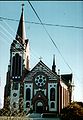
Roman Catholic Church Szentlélek

Interior of the church

Water tower in Vállaj


literature
- Vállaj - Településképi Arculati Kézikönyv 2017. Published by the municipal administration, Vállaj 2017.
Web links
- Official website ( Hungarian )
- Vállaj at tourinform.hu (Hungarian)