Venustiano Carranza (Delegación)
| Venustiano Carranza | ||
|---|---|---|

|
||
| Symbols | ||
|
||
| Basic data | ||
| Country | Mexico | |
| Capital district | Mexico city | |
| surface | 34 km² | |
| Residents | 430,978 (2010) | |
| density | 12,688.9 inhabitants per km² | |
| Website | vcarranza.df.gob.mx | |
| INEGI no. | 09017 | |
| politics | ||
| Jefe delegacional | Israel Moreno Rivera | |
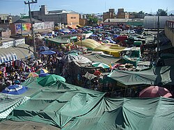
| View over the Mercado de la Merced | ||
Coordinates: 19 ° 25 ′ 9 ″ N , 99 ° 6 ′ 36 ″ W.
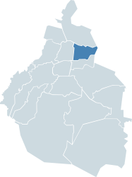
The Delegación Venustiano Carranza , named after the first post-revolutionary president of Mexico , is one of 16 districts ( delegaciones ) of Mexico City . It is located in the east of the Mexican capital and borders three delegaciones of the same: in the west on Cuauhtémoc with the historic city center, in the north on Gustavo A. Madero and in the south on Iztacalco . To the east is the state of México .
Attractions
In the Venustiano Carranza district are the Benito Juárez International Airport , the Palacio de Lecumberri with the National Archives, the Palacio Legislativo de San Lázaro , seat of the Mexican House of Representatives, and the Museo Legislativo "Sentimientos de la nación" . The district is also home to three of Mexico City's premier markets: La Merced , Sonora, and Jamaica .
Individual evidence
- ↑ Turismo en la Delegación Venustiano Carranza ( Memento of the original from November 27, 2011 in the Internet Archive ) Info: The archive link has been inserted automatically and has not yet been checked. Please check the original and archive link according to the instructions and then remove this notice. (Spanish; accessed June 7, 2013)
Web links
- Official website of the Delegación Venustiano Carranza (Spanish)
- Enciclopedia de los Municipios y Delegaciones de México: Delegación Venustiano Carranza (Spanish)
- INEGI : Datos Geográficos: Delegación Venustiano Carranza (Spanish; PDF)


