
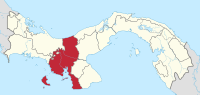
Veraguas Province
| Veraguas | |
|---|---|
  |
|
| Data | |
| Capital | Santiago de Veraguas |
| population | 222,382 (2004) |
| surface | 10,630 km² |
| Population density | 21 people / km² |
| structure | 12 distritos |
| Other cities | El Tigre , Santa Fe |
| Rivers |
Rio Santa Maria , Rio San Pablo |
| ISO 3166-2 | PA-9 |
 |
|
Veraguas is the third largest province in Panama and is the only one that borders both the Pacific and the Atlantic .
The capital of Veraguas is Santiago de Veraguas in the east of the province. The coastline on the Atlantic is 43 kilometers and on the Pacific 353 kilometers. Veraguas includes around 40 smaller and larger islands, the largest of which is Isla de Coiba in the Gulf of Chiriquí , which is the largest island of Panama with 493 km².
Around 4% of the population belong to the indigenous population group. The main economic factors in Veraguas are agriculture ( rice , maize , sugar cane , coffee ) and, in recent years, increasingly tourism (especially on the Azuero peninsula).
The province of Veraguas is in turn divided into twelve districts ( distritos ) with a total of 95 municipalities ( corregimientos ) (in brackets the respective district capital):
- Atalaya (Atalaya)
- Calobre (calobre)
- Cañazas (Cañazas)
- La Mesa (La Mesa)
- Las Palmas (Las Palmas)
- Montijo (Montijo)
- Río de Jesús (Río de Jesús)
- San Francisco (San Francisco)
- Santa Fe (Santa Fe)
- Santiago (Santiago de Veraguas)
- Soná (Soná)
- Mariato (Mariato)
Provinces: Bocas del Toro | Chiriquí | Coclé | Colón | Darién | Herrera | Los Santos | Panamá | Panamá Oeste | Veraguas
Territories: Emberá-Wounaan | Guna Yala | Ngöbe-Buglé - without provincial status: Kuna de Madugandí | Kuna de Wargandí
Coordinates: 8 ° 0 ′ N , 81 ° 12 ′ W