Double
| Double | ||
|
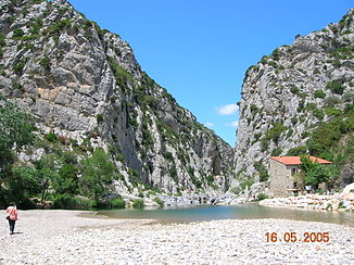
The Gouleyrous gorge |
||
| Data | ||
| Water code | FR : Y0650500 | |
| location | France , Occitania region | |
| River system | Agly | |
| Drain over | Agly → Mediterranean | |
| River basin district | FRD Rhône | |
| source | in the municipality of Soulatgé 42 ° 53 ′ 20 ″ N , 2 ° 28 ′ 7 ″ E |
|
| Source height | approx. 750 m | |
| muzzle | in the municipality of Estagel in the Agly coordinates: 42 ° 46 ′ 44 ″ N , 2 ° 43 ′ 8 ″ E 42 ° 46 ′ 44 ″ N , 2 ° 43 ′ 8 ″ E |
|
| Mouth height | approx. 61 m | |
| Height difference | approx. 689 m | |
| Bottom slope | approx. 15 ‰ | |
| length | 47 km | |
| Catchment area | 321 km² | |
| Left tributaries | Torgan , Tarrasac | |
The Verdouble is a river in France that runs in the Occitania region . It rises in the highlands of the Haute Corbières , in the municipality of Soulatgé , near the border with the neighboring municipality of Cubières-sur-Cinoble , initially drains generally east to southeast, is then diverted by a ridge to the southwest and flows after 47 kilometers in the municipality of Estagel as a left tributary into the Agly . On its way, the Verdouble crosses the Aude and Pyrénées-Orientales departments .
Places on the river
Attractions
- Château de Peyrepertuse ( Monument historique ) - Cathar fortress from the 11th century high above the river valley
- Arago Cave , prehistoric site in the Gorges de Gouleyroux
Web links
Commons : Verdouble - collection of images, videos and audio files
Remarks
- ↑ Source geoportail.fr (1: 32,000)
- ↑ estuary geoportail.fr (1: 16,000)
- ↑ a b c The information on the river length is based on the information about the Verdouble at SANDRE (French), accessed on May 4, 2012, rounded to full kilometers.
