
Tautavel
|
Tautavel valley valley |
||
|---|---|---|

|
|
|
| region | Occitania | |
| Department | Pyrénées-Orientales | |
| Arrondissement | Perpignan | |
| Canton | La Vallée de l'Agly | |
| Community association | Perpignan Méditerranée Métropole | |
| Coordinates | 42 ° 49 ′ N , 2 ° 45 ′ E | |
| height | 65-566 m | |
| surface | 53.47 km 2 | |
| Residents | 866 (January 1, 2017) | |
| Population density | 16 inhabitants / km 2 | |
| Post Code | 66720 | |
| INSEE code | 66205 | |
 Tautavel - view from the Tour de Far |
||

.jpg)
Tautavel ( Catalan Talteüll ) is a place and a French commune with 866 inhabitants (as of January 1, 2017) in the Pyrénées-Orientales department in the Occitania region . The place became internationally known through the Homme de Tautavel, who was found in a nearby cave in 1971 .
Location and climate
The wine-growing town of Tautavel is located on the banks of the Verdouble river , on the southern foothills of the Corbières , about 33 km (driving distance) northwest of Perpignan at an altitude of about 100 to 120 m . The climate is temperate to warm; Rain (approx. 620 mm / year) falls over the year.
Population development
| year | 1800 | 1851 | 1901 | 1954 | 1999 | 2016 |
|---|---|---|---|---|---|---|
| Residents | 476 | 724 | 1,201 | 925 | 851 | 872 |
| Source: Cassini and INSEE | ||||||
Despite the phylloxera crisis in viticulture and the increasing mechanization of agriculture , the population of the municipality has remained largely stable since the beginning of the 20th century.
economy
Only a small part of the municipal area is used for agriculture, with viticulture playing an important role. Large parts are covered by forest or lie fallow; there are several quarries.
history
Today's southern French region of Languedoc-Roussillon was populated by representatives of the genus Homo 450,000 years ago . The presence of Celts , Romans, Visigoths and Muslims for Tautavel, however, cannot be proven by archaeological finds or written sources. Only in the Middle Ages did the area regain a certain importance: In 1011, Count Bernard I of Besalú gave the castle of Tautavel and some other lands into the hands of his son Wilhelm. In the 13th century the area belonged to the Counts of Vernet and the Kingdom of Mallorca . In 1418 it finally came to the Crown of Aragón and stayed there until the Peace of the Pyrenees (1659). Then it was border area with Spain .
Attractions
- A replica of the Arago Cave can be seen in the local Musée de Préhistoire . Copies of Homo erectus fossils , stone tools and originals of animal fossils are also exhibited there. In several dioramas , worlds from the era of the Hommes de Tautavel and the later Neanderthals come to life.
- Only ruins remain of the castle of the Château de Tautavel .
- The Église Saint-Génis dates from the 16th / 17th centuries. Century.
- Surroundings
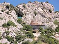
- The cave of Arago (Caune d'Arago) , located approx. 3 km north of the village, cannot be visited.
- The Tour del Far watchtower, high above the town (498 m), dates from the time of the Kingdom of Mallorca.
- The Chapelle de Saintes-Puelles , located about 2 km south of the village near the road to Estagel , is a simple, but worth seeing building from the early 19th century.
Arago cave

Viticulture in Tautavel

View of Tautavel from the direction of Vingrau

Wine landscape near Tautavel
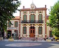
Mayor's office

Main road


.jpg)


Web links
- Tautavel, history and sights - photos + information (French)
- tautavel.com/ Tautavel, website of the municipality - photos + information (French)