Pézilla-la-Rivière
|
Pézilla-la-Rivière Pesillà de la Ribera |
||
|---|---|---|

|
|
|
| region | Occitania | |
| Department | Pyrénées-Orientales | |
| Arrondissement | Perpignan | |
| Canton | Le Ribéral | |
| Community association | Perpignan Méditerranée Métropole | |
| Coordinates | 42 ° 42 ′ N , 2 ° 46 ′ E | |
| height | 40-243 m | |
| surface | 15.62 km 2 | |
| Residents | 3,662 (January 1, 2017) | |
| Population density | 234 inhabitants / km 2 | |
| Post Code | 66370 | |
| INSEE code | 66140 | |
| Website | http://www.mairie-pezilla-riviere.fr/index.htm | |
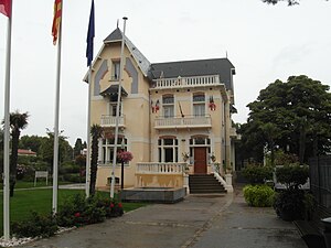
 Town hall of Pézilla-la-Rivière |
||
Pézilla-la-Rivière ( Catalan: Pesillà de la Ribera ) is a French commune in the department of Pyrenees-Orientales in the region Occitania . The municipality has an area of 15.62 km² and has 3662 inhabitants (as of January 1, 2017). Pézilla-la-Rivière belongs to the Arrondissement of Perpignan and is part of the canton of Le Ribéral . The inhabitants are called Pézillanais (es) .
geography
Pézilla-la-Rivière is bounded in the south by the river Têt and lies in the Ribéral region . The Côtes du Roussillon-Villages wine-growing region extends into the municipality . Pézilla-la-Rivière is surrounded by the neighboring communities of Calce in the north, Villeneuve-la-Rivière in the east, Le Soler in the southeast, Saint-Féliu-d'Avall in the south and Corneilla-la-Rivière in the west.
Population development
| 1962 | 1968 | 1975 | 1982 | 1990 | 1999 | 2006 | 2017 |
|---|---|---|---|---|---|---|---|
| 2091 | 2159 | 2058 | 2200 | 2349 | 2754 | 3052 | 3662 |
Community partnerships
There are partnerships with the Italian municipality of Tramonti in the province of Salerno (Campania) since 2001 and the Nigerian municipality of Say .
Attractions
- Saint-Saturnin Church
- Gate of the previous fortification
Personalities
- Joseph Napoléon Sébastien Sarda Garriga (1808–1877), colonial ruler (including on Réunion and in Guyana)
