Vicdessos (river)
| Vicdessos | ||
|
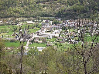
The place Vicdessos in the valley of the river of the same name |
||
| Data | ||
| Water code | FR : O11-0400 | |
| location | France , Occitania region | |
| River system | Garonne | |
| Drain over | Ariège → Garonne → Atlantic Ocean | |
| source | in the municipality of Auzat 42 ° 36 ′ 38 ″ N , 1 ° 25 ′ 59 ″ E |
|
| Source height | approx. 2580 m | |
| muzzle | in the urban area of Tarascon-sur-Ariège in the Ariège coordinates: 42 ° 50 ′ 45 ″ N , 1 ° 36 ′ 21 ″ E 42 ° 50 ′ 45 ″ N , 1 ° 36 ′ 21 ″ E |
|
| Mouth height | approx. 470 m | |
| Height difference | approx. 2110 m | |
| Bottom slope | approx. 57 ‰ | |
| length | 37 km (see notes) | |
| Right tributaries | Siguer | |
| Reservoirs flowed through | Étang de Soulcem | |
The Vicdessos is a river in France that runs in the Ariège department in the Occitania region . Its source brook Ruisseau de Médécourbe rises in the Pyrenees , near the border with Spain , on the eastern flank of the Brèche des Lavans (2664 m), in the municipality of Auzat . He generally dehydrated direction north to northeast by the Regional Park Pyrénées Ariégeoises and opens after 37 kilometers in urban area of Tarascon-sur-Ariège as left tributary in the Ariège .
