Vikna
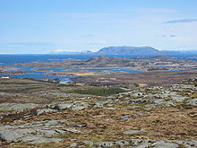
Vikna was an island community on the coast Namdalens in Norwegian Fylke Trøndelag , consisting of nearly 6,000 islands, Holmen and archipelago was. The administrative center was in Rørvik . As part of the municipal reform in Norway , Vikna and Nærøy merged on January 1, 2020 to form the new municipality of Nærøysund .
4578 inhabitants lived in an area of 317 km² (as of January 1, 2019). The municipality bordered Leka to the north, Flatanger to the south and Nærøy to the east . The municipality number was 5050.
The municipality was divided into three island areas: Indre Vikna, Mellom Vikna and Ytre Vikna. Most of the residents lived on the largest islands, all of which, with the exception of Borgan, are connected by a bridge. Rørvik is located in Indre-Vikna. The highest point in the municipality was Vattafjellet at 173 meters, also in Indre-Vikna. 85% of the municipality were below 60 meters. With a length of 2460 kilometers, Vikna has the longest coastline in Norway.
The municipal coat of arms shows three silver salmon on a blue background.
history
Since the first settlements, fishing has been an important prerequisite for survival. In the 15th and 16th centuries, the Hanseatic League offered good sales opportunities for fish, which led to an increase in the population. The population in Vikna also increased later - in the period from 1876 to 1891 alone by 41.4%. Industrialization and centralization efforts in the 20th century led to a depopulation of the outer areas. With the same number of inhabitants in the municipality, however, Rørvik rose as the center of the municipality. Due to its favorable geographical location, the main town represented a natural hub for the community for 100 years.
Economy and Transport
Fishing was the main industry in the municipality. Due to its location on the North Sea, the largest fishing community in North Trøndelag was created here.
The community could be reached by car via Reichsstraße 770, which connects Vikna with the tourist-marketed coastal road Fv17 . A fast ferry connected Vikna three times a day with Namsos , the next largest city on the mainland. In addition, the municipality was called at every evening by the Hurtigruten ships. Outside Rørvik there is a regional airport, Rørvik Airport , which is served by aircraft operated by the airline Widerøe .
Culture
In the summer of 2004, the Coastal Museum was opened by King Harald V and Queen Sonja of Norway and is located a hundred meters from the Hurtigruten quay in Rørvik. The museum also includes an old trading yard. The main building was designed by the Icelandic architect Guðmundur Jónsson and was nominated for the Mies van der Rohe Architecture Prize in 2005. In the summer it is also worth taking a trip to the fishing village of Sør-Gjæslingan, which can be reached by speedboat and offers overnight accommodation.
Personalities
- Asbjørn Sunde (1909–1985), resistance activist during the Second World War
- Harriet Andreassen (1925–1997), politician of the labor party
- Lars Peder Brekk (* 1955), Senterpartiet politician
Web links
- Norveg Coast Museum (Norwegian)
Individual evidence
- ↑ Navn på nye kommuner. February 19, 2019, accessed January 27, 2020 (Norwegian).
- ↑ lovdata.no: Forskrift om the collection of Nærøy commune and Vikna commune to Nærøysund commune, Trøndelag. April 30, 2018, accessed January 6, 2020 (Norwegian Bokmål).
- ↑ a b Vikna kommune: Om communen , accessed on September 24, 2010 (Norwegian)
- ↑ Vikna Næringsforening: Opplev Vikna ( Memento of the original from January 19, 2010 in the Internet Archive ) Info: The archive link was inserted automatically and has not yet been checked. Please check the original and archive link according to the instructions and then remove this notice. , accessed September 24, 2010 (Norwegian)
- ^ Norveg - Center for Kystkultur og Kystnæring. Retrieved June 20, 2019 (Norwegian).
- ↑ Sør-Gjæslingan. Accessed June 20, 2019 (German).
Coordinates: 64 ° 54 ′ 42 " N , 11 ° 1 ′ 55" E


