
Victoria Falls
| Mosi-oa-Tunya / Victoria Falls | |
|---|---|
|
UNESCO world heritage |
|

|
|
|
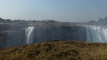
Oblique aerial view of Victoria Falls with a view to the north, up the wide upper reaches of the Zambezi; at the bottom in the middle the boiling pot, to the left of it the Victoria Falls Bridge |
|
| National territory: |
|
| Type: | nature |
| Criteria : | vii, viii |
| Surface: | 6,860 ha |
| Reference No .: | 509 |
| UNESCO region : | Africa |
| History of enrollment | |
| Enrollment: | 1989 (session 13) |
The Victoria Falls are a wide waterfall the Zambezi River between the border towns of Victoria Falls in Zimbabwe and Livingstone in Zambia . Since 1989, the cases included in the World Heritage of UNESCO .
General
.jpg)

The first European to see Victoria Falls with their own eyes was the Scottish missionary and Africa traveler David Livingstone . After hearing reports about this waterfall in 1851, it landed four years later, on November 16, 1855, on the small island that lies directly on the edge over which the Zambezi plunges into the depths and which is now named Livingstone Island carries. Deeply impressed, he described the waterfall as "the most beautiful that he has ever seen in Africa" and named it Victoria Falls ; in honor of the then British Queen Victoria .


The local Kololo however call the waterfall Mosi-oa-Tunya (in German: thundering smoke ). The name refers to the water spray that rises from the falls at a height of up to 300 m and can still be seen up to 30 km away. In the immediate vicinity of Victoria Falls there is even a rainforest , which only owes its existence to the moisture of this spray mist. This arises because the water masses of the Zambezi pour over a width of 1708 m into a 110 m deep and barely more than 50 m wide gorge with steep basalt rock walls lying across the river . This makes the Victoria Falls the widest continuous waterfall on earth. At the end of the rainy season in February and March, when the Zambezi is heavily swollen by the rainfall, up to 10,000 m³ / s of water shoots over the northern edge of the gorge, but the waterfall is also the title in most of the other months of the year “Largest water curtain on earth”. At the end of the dry season, in the months of September and October, however, the amount of water can shrink to just 170 m³ / s. Then only a few rivulets remain of the otherwise roaring tide.
The Victoria Falls are considered to be the border between the wide upper reaches and the rather narrow middle reaches of the Zambezi, narrowed by gorges, which extends to the Cahora-Bassa dam in Mozambique.
The Victoria Falls have been protected across borders since 1934 and have been part of the Mosi-oa-Tunya National Park since 1972 . The rather small but largely touristically developed national park extends from the falls about 12 km upstream and covers about 66 km². In addition, the Victoria Falls are located in the area of the Kavango-Zambezi Transfrontier Conservation Area , an international protected area in southern Africa that has existed since March 2012.
A special tourist attraction is Devil's Pool, a small natural pool that lies directly on the edge of the waterfall and can be safely used for swimming from September to December, i.e. when the water level in the river is low.
Zimbabwe is currently planning to build a $ 300 million (approx. 230 million euros) amusement park around the Victoria Falls to attract more tourists.
Geology and formation
The Victoria Falls are both the result and only a stopover of the retrograde erosion of the Zambezi in interaction with the special regional geology in the southern part of the southern province of Zambia and the adjacent area in Zimbabwe. There is a deposit of Karoo basalts, the so-called Batoka Formation, which is crossed by the Zambezi. The basalts have a right-angled fracture system of approximately north-south and approximately east-west oriented fissures that overlap like a grid. These fissures are filled with sediments (including sandstone ) that were once deposited on the basalts, but have now eroded again .
The sediments are significantly less resistant to erosion than basalt and are relatively easily cleared out by the river. Therefore, a wide waterfall is created where the course of the river crosses a chasm that runs perpendicular to the direction of flow. In the case of Victoria Falls and their geologically most recent predecessors, this affects east-west-oriented fissures, as the river in this area flows in a north-south direction. If such an east-west gap has been freed of sediment to such an extent that the receding erosion can spread to a north-south gap, the migration of the waterfall towards the Zambezi source continues in this same gap. The north-south rift, which was cleared out immediately before the Victoria Falls formed, is the so-called Boiling Pot at the eastern end of today's waterfall. While a north-south chasm is being cleared, a relatively narrow waterfall exists - until the next east-west chasm is reached and, as with Victoria Falls, the next wide waterfall is created.
Below the Victoria Falls, the river zigzags through narrow, deep, roughly east-west-oriented gorges, which are connected by rather short north-south-oriented sections. These gorges represent fissures in the basalt that have been freed from their sedimentation, and a predecessor of the Victoria Falls spilled over the northern edge of each of these gorges.
While the Zambezi flows over the basalts in a wide river bed above the Victoria Falls, it actually flows through them below, channeled through fissures that it has cleared itself over the past centuries.
Above today's Victoria Falls, when the water level is low, the east-west gaps in the river bed can already be seen in aerial photographs, where the falls will be located in a few 10,000 years.
meaning
After it was declared a World Heritage Site by UNESCO, conflicts arose over the possible use of the hydroelectric energy potential of the Zambezi. The development of the river as a source of energy, since it forms the border between Zambia and Zimbabwe here, is of great importance for both neighboring countries. The Zambezi River Authority is planning to build another dam on the Batoka Gorge below the falls. Along with the Kariba Dam and the Cahora-Bassa Dam, this would be the third major dam project on the Zambezi. Conservationists warned of the unique flora and fauna in the previously undisturbed gorge. With the damming of the river so close to the falls, they fear not only the impairment of the natural landscape but also changes in the gorges below the falls and losses in the lucrative tourism business.
Climate table
| Climate diagram | ||||||||||||||||||||||||||||||||||||||||||||||||
|---|---|---|---|---|---|---|---|---|---|---|---|---|---|---|---|---|---|---|---|---|---|---|---|---|---|---|---|---|---|---|---|---|---|---|---|---|---|---|---|---|---|---|---|---|---|---|---|---|
| ||||||||||||||||||||||||||||||||||||||||||||||||
|
Average monthly temperatures and rainfall at Victoria Falls
Source:
|
|||||||||||||||||||||||||||||||||||||||||||||||||||||||||||||||||||||||||||||||||||||||||||||||||||||||||||||||||||||||||||||||||||||||||||||||||||||||||||||||||||||

literature
- David Livingstone: Mission Travel and Research in South Africa. German edition in two volumes Leipzig, Verlag Hermann Costenoble 1858.
Web links
- Victoria Falls on YouTube by Milosh Kitchovitch
- The Victoria Falls , website of the Zambia National Tourist Board
- Entry on the UNESCO World Heritage Center website ( English and French ).
- Mosi-oa-Tunya National Park - Official website
- Short biography of David Livingstone together with an excerpt from his book on Africa about the discovery of the Victoria Falls of the Zambezi - both come from the book From Greenland to Lambarene. Travel descriptions by Christian missionaries from three centuries. Edited by John Paul . Evangelische Verlagsanstalt Berlin 1952 (pp. 74–82) / Kreuz-Verlag Stuttgart 1958 (pp. 70–78).
- Victoria Falls: Angels on the Abyss (Spiegel Online)
- Historic photograph of the Boiling Pot in the World Digital Library
Individual evidence
- ↑ Devil's Pool - description at touring-afrika.de , accessed on July 22, 2012
- ↑ Nikki and Michi Dunker: Devils Pool Victoria Falls Zambia (bath in Devil's Pool) Video on YouTube , accessed on May 25, 2016
- ^ Zimbabwe outlines plans for 'Disneyland in Africa'. BBC News, August 27, 2013
- ↑ the entire section is based on Peter Roberts: Formation of the Victoria Falls. In: To The Victoria Falls - A Natural Wonder . 2012. Website with a lot of information about Victoria Falls and the Zambezi (accessed December 24, 2012)
- ↑ wetterkontor.de

Cultural heritage: Great Zimbabwe National Monument (1986) | National Monument Ruins of Khami (1986) | Matobo Mountains (2003)
Natural heritage: Mana Pools National Park , Sapi and Chewore safari areas (1984) | Mosi-oa-Tunya / Victoria Falls (1989)
Coordinates: 17 ° 55 ′ 28.1 ″ S , 25 ° 51 ′ 18.1 ″ E