
Vila Nova de Santo André
| Vila Nova de Santo André | ||||||
|---|---|---|---|---|---|---|
|
||||||
| Basic data | ||||||
| Region : | Alentejo | |||||
| Sub-region : | Alentejo Littoral | |||||
| District : | Setubal | |||||
| Concelho : | Santiago do Cacém | |||||
| Coordinates : | 38 ° 4 ′ N , 8 ° 47 ′ W | |||||
| Residents: | 10,647 (as of June 30, 2011) | |||||
| Surface: | 75.11 km² (as of January 1, 2010) | |||||
| Population density : | 142 inhabitants per km² | |||||
| politics | ||||||
| Address of the municipal administration: | Junta de Freguesia de Vila Nova de Santo André Largo 20 Junho 11-B 7500-011 Vila Nova de Santo André |
|||||
| Website: | www.santoandre.pt | |||||


Vila Nova de Santo André or shortly Santo André is a Portuguese parish and town (Cidade) that the county Santiago do Cacém belongs. It occupies an area of 75.1 km² and has 10,647 inhabitants (as of June 30, 2011), which results in a population density of 142 inhabitants per km².
history
The place received city rights in 2003. The municipality of Santo André also includes the nature reserve around the Lagoa de Santo André (a natural lagoon lake with sea water) and the beach town of Santo André with its kilometer-long sandy beach, which has become more and more important in terms of tourist activities in recent years.
The actual city of Vila Nova de Santo André is a few kilometers away from the coast in the hinterland. The city was built together with the Sines petrochemical industrial complex , so many workers and employees of the industrial site live there.
Historical buildings
- Church of Nossa Senhora da Graça and the source of Nossa Senhora da Graça
gallery

Historic church in VN de Santo André
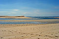
Bathing beach of Lagoa de Santo André


Individual evidence
- ↑ www.ine.pt - indicator resident population by place of residence and sex; Decennial in the database of the Instituto Nacional de Estatística
- ↑ Overview of code assignments from Freguesias on epp.eurostat.ec.europa.eu
Web links
- Map of the Freguesia Vila Nova de Santo André at the Instituto Geográfico do Exército
