Santiago do Cacém
| Santiago do Cacém | ||||||
|---|---|---|---|---|---|---|
|
||||||
| Basic data | ||||||
| Region : | Alentejo | |||||
| Sub-region : | Alentejo Littoral | |||||
| District : | Setubal | |||||
| Concelho : | Santiago do Cacém | |||||
| Coordinates : | 38 ° 1 ′ N , 8 ° 42 ′ W | |||||
| Residents: | 7589 (as of June 30, 2011) | |||||
| Surface: | 119.53 km² (as of January 1, 2010) | |||||
| Population density : | 63 inhabitants per km² | |||||
| Postal code : | 7540 | |||||
| politics | ||||||
| Mayor : | Vítor Paulo de Jesus Miguel Barata ( CDU ) | |||||
| Address of the municipal administration: | Junta de Freguesia de Santiago do Cacém Rua Ramos Costa 7540-205 Santiago Cacém |
|||||
| Santiago do Cacém County | ||||||
|
||||||
| Residents: | 29,749 (as of June 30, 2011) | |||||
| Surface: | 1 059.7 km² (as of January 1, 2010) | |||||
| Population density : | 28 inhabitants per km² | |||||
| Number of municipalities : | 8th | |||||
| administration | ||||||
| Administration address: | Câmara Municipal de Santiago do Cacém Praça do Município 7540-186 Santiago do Cacém |
|||||
| President of the Câmara Municipal: | Álvaro Beijinha ( CDU ) | |||||
| Website: | www.cm-santiagocacem.pt | |||||
Santiago do Cacém is a city in Portugal . Santiago do Cacém is the seat of the district of the same name. The municipality of Santiago do Cacém, covers an area of 119.5 km² and 7589 inhabitants (as of June 30, 2011). The population density is 63.5 inhabitants per km².
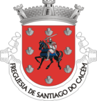
coat of arms
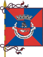
Blazon : "In red within a red border covered by eight silver scallops , a black-bearded, silver knight on a blue-bridled, black steed, his right forehand raised and angled, dressed in a helmet, chain mail, red-lined robe, his right hand raised with a sword over his head, in the left an oval shield with a red lily cross. "
Declaration of the coat of arms: The red lily cross represents a Jacob's cross , the rider a knight of the Jacobean Order (Portuguese Ordem Militar de Santiago ), the shells are an attribute of St. James ( Santiago ), who is particularly venerated in the west of the Iberian Peninsula (see Santiago de Compostela in Northern Spain).
history
The human settlement of the area around Santiago de Cacém can be traced at the archaeological points still existing in the area, which date from the epoch between the Stone Age and the Roman Empire. Megalithic tombs bear witness to the first settlers in this coastal region, which later, before the Romans, was probably settled by Celts . The suffix -briga of the later Roman place indicates that the Celtic population existed at that time.
From the Roman era, 1 km east of the village, there is the archaeological site of Miróbriga , which is known beyond the national borders and was an important cultural center for the entire coastal area in Roman times. Also nearby, a Roman hippodrome was uncovered, which is unique at least on the Portuguese west coast. After the Romans, the Teutons came to what is now Portugal around 410, followed by the Visigoths around 600. Around the year 700, large parts of the Iberian Peninsula were conquered by the Moors, who ruled in the area of Santiago until the 12th century. The new conquerors lived in the castle of "Kassem", which, next to the seaport Alcácer do Sal, was a focal point of the southern coastal region. The old town behind the castle has foundations that date back to this time. After the last Arab-occupied territories were conquered in the 12th century, the medieval castle of "Sant 'Iago de Kassem" continued to be of great importance. Santiago de Cacém became part of the Portuguese Kingdom. Under King Dionysius ( Dom (D.) Dinis I), Santiago de Cacém received its first official city charter "Carta de Foral" around 1300. Members of the royal family also lived in the castle at times.
In 1833 the local district parliament (chamber) of S. Tiago do Cacém was officially established with 3 deputies and a public prosecutor. In 1895 the first car came to Portugal, which belonged to the then Conde de Avillez, who resided in Santiago.
Due to its beautiful location above the sea, Santiago de Cacém was also called Sintra des Alentejo after the Second World War , based on the town of Sintra as an upstream resort from Lisbon on the Atlantic Ocean. Since then, tourism has become more and more important in Santiago de Cacém. Santiago do Cacém was granted city rights in 1991 .
Today the main town is still around a mountain with the castle ruins. From up here you have a wonderful view of the nearby beaches of the Atlantic Ocean and the industrial metropolis of Sines . There is a historic town center behind the castle ruins and a newer town center around the market building. Santiago do Cacém is an agricultural center. Cattle breeding and cork harvesting are in the foreground. Santiago has its own tourist infrastructure with accommodation and restaurants. There is also one of the traditional Portuguese pousadas in town . The city has a centuries-old culture of instrument making. It is also worth mentioning the excellent city museums of Santiago do Cacém as well as the archaeological sites of the Roman settlement Miróbriga on the outskirts, which contain sanctuaries, thermal baths and a racecourse.
Historical buildings
- Area of the old castle - Castelo de Santiago do Cacém
- Excavations of the Roman settlement Miróbriga
- Church of Santiago and Church of Matriz de Santiago do Cacém
- Nossa Senhora do Loreto Abbey (ruins)
- Chapel of São Brás
- Ermida de Sao Sebastiao
- Chafariz da Senhora do Monte
- Pelourinho de Santiago do Cacém
- Chapel of São Pedro
- Pousada of Santiago do Cacém
administration
The circle
Santiago do Cacém is the administrative seat of a district of the same name ( concelho ) in the Setúbal district . On June 30, 2011, the district had 29,749 inhabitants on an area of 1,059.7 km².
The neighboring regions are (starting clockwise in the north): Grândola , Ferreira do Alentejo , Aljustrel , Ourique , Odemira , Sines and the Atlantic Ocean. Santiago do Cacém is part of the Alentejo Litoral , this is a sub-region in Portugal .
The district of Santiago do Cacém is made up of eight parishes ( freguesias ):
| local community | Population (2011) |
Area km² |
Density of population / km² |
LAU code |
|---|---|---|---|---|
| Abela | 890 | 137.68 | 6th | 150901 |
| Alvalade | 2,098 | 161.82 | 13 | 150902 |
| Cercal do Alentejo | 3,362 | 137.49 | 24 | 150903 |
| Ermidas-Sado | 2,020 | 82.40 | 25th | 150904 |
| Sao Francisco da Serra | 809 | 51.38 | 16 | 150910 |
| Santiago do Cacém, Santa Cruz e São Bartolomeu da Serra | 8,454 | 207.93 | 41 | 150912 |
| São Domingos e Vale de Água | 1,469 | 205.89 | 7th | 150913 |
| Vila Nova de Santo André | 10,647 | 75.11 | 142 | 150907 |
| Santiago do Cacém County | 29,749 | 1,059.70 | 28 | 1509 |
Population development
| Population in Santiago do Cacém County (1801–2011) | |||||||||
|---|---|---|---|---|---|---|---|---|---|
| 1801 | 1849 | 1900 | 1930 | 1960 | 1981 | 1991 | 2001 | 2004 | 2011 |
| 6854 | 8045 | 18,576 | 25,878 | 33,579 | 29,191 | 31,475 | 31,105 | 30.203 | 29,720 |
Municipal holiday
- July 25th
Town twinning
-
 Palmela , Portugal (since 1993)
 -
 Santiago de Compostela , Galicia , Spain (since 2007)
sons and daughters of the town
- Manuel da Fonseca (1911–1993), neorealist writer
- Francisco Guerreiro (* 1984), PAN politician , Member of the European Union since 2019
- Aurea (* 1987), pop singer
Web links
- Map of the Freguesia Santiago do Cacém at the Instituto Geográfico do Exército
- Official website of the Camara Municipal (Administration)
- Comprehensive information about the Roman settlement Mirobriga
Individual evidence
- ↑ www.ine.pt - indicator resident population by place of residence and sex; Decennial in the database of the Instituto Nacional de Estatística
- ↑ a b Overview of code assignments from Freguesias on epp.eurostat.ec.europa.eu
- ↑ a b www.ine.pt - indicator resident population by place of residence and sex; Decennial in the database of the Instituto Nacional de Estatística
- ↑ www.anmp.pt , accessed November 25, 2013


