Alcácer do Sal
| Alcácer do Sal | ||||||
|---|---|---|---|---|---|---|
|
||||||
| Basic data | ||||||
| Region : | Alentejo | |||||
| Sub-region : | Alentejo Littoral | |||||
| District : | Setubal | |||||
| Concelho : | Alcácer do Sal | |||||
| Coordinates : | 38 ° 22 ′ N , 8 ° 30 ′ W | |||||
| Residents: | 13,046 (as of June 30, 2011) | |||||
| Surface: | 1 499.87 km² (as of January 1, 2010) | |||||
| Population density : | 8.7 inhabitants per km² | |||||
| Alcácer do Sal district | ||||||
|
||||||
| Residents: | 13,046 (as of June 30, 2011) | |||||
| Surface: | 1 499.87 km² (as of January 1, 2010) | |||||
| Population density : | 8.7 inhabitants per km² | |||||
| Number of municipalities : | 4th | |||||
| administration | ||||||
| Administration address: | Câmara Municipal de Alcácer do Sal Largo Pedro Nunes 7580-125 Alcácer do Sal |
|||||
| President of the Câmara Municipal: | Pedro Manuel Igrejas da Cunha Paredes | |||||
| Website: | www.cm-alcacerdosal.pt | |||||
Alcácer do Sal is a city ( Cidade ) and a district ( concelho ) in Portugal with 13,046 inhabitants (as of June 30, 2011). The district belongs to the Setúbal district and is traditionally assigned to the Alentejo Litoral region.
history
The settlement of the area around Alcácer do Sal can be traced in the archaeological sites existing in the area , which date from the epochs between the Stone Age ( Olival do Senhor dos Mártires necropolis ), Phoenician period ( Abul ), Roman Empire and Islamic settlement. The first settlers came from Galicia . Witnesses of this time are the places of worship and megalithic sites in the area .
Abul is the only Phoenician trading post discovered so far on the Portuguese coast. It is located in the funnel of the Rio Sado , near Alcácer do Sal. Under the Romans there were strong fish processing activities in Alcácer do Sal. This is shown by the excavations of clay vessels and pottery kilns ( Quinta do Rouxinol ) in the area. Among other things, a large Roman wall was uncovered in connection with a room that was covered with white marble floors.
After the Romans, Germanic tribes came to the area of today's Portugal ( Suebi and Visigoths ) from 410 AD . Around the year 700 large parts of the Iberian Peninsula were conquered by the Moors , who ruled in the area of Alcácer do Sal until the 12th century. The new conquerors lived in the castle above the town of "Al Kasr", which, along with Santiago do Cacém, was the center and regional capital of the southern coastal region. The castle of Alcácer do Sal goes back to Moorish origins and its walls are still relatively well preserved to this day. An exterior tower is reminiscent of Badajoz Castle in its design . The castle walls frame a large inner area that was built on with buildings. In the wall there were two large gates to the north and east. For the Arabs and Berbers (in the 9th and 10th centuries the Banū Dānis dominated ), Alcácer do Sal was more important as a military base than Setúbal, which already existed at that time . The old town located under the castle has foundations that go back to the Moorish period. At that time, Alcácer do Sal was a navigable port for the ship types of the Arabs, which lay protected in the river course of the Sado Delta. Today the Sado is silted up and is no longer suitable for shipping.
Alcácer do Sal and its castle were after a two-month siege by the Christians under Alfonso II (1211-23), supported by crusaders of the Fifth Crusade , who wintered in Portugal on the way to Palestine, and the Bishop of Lisbon, Soeiro Viegas, on Captured October 18, 1217 .
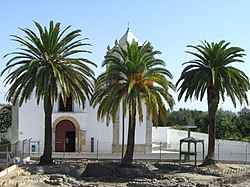
After the last Arab-occupied territories were conquered in the 12th century, the castle of "Al Kasser" continued to be of great importance. Alcácer do Sal became part of the Portuguese Kingdom. The still well-preserved chapel of the 11,000 virgins was built as part of the Franciscan monastery with its church of St. António in 1524 by King D. João III. built.
Due to its location above the Rio Sado, Alcácer do Sal became more and more of a tourist metropolis after the Second World War . The fact that the place is close to the Atlantic beaches of the Alentejo ( Comporta and Carvalhal ) and the delta of the Rio Sado was made a nature reserve after the Carnation Revolution of 1974 also contributes to this. During the Carnation Revolution from 1974 to 1976, the cooperatives of Alcácer do Sal were the leading forces in the land occupation and cooperative movement of the Alentejo. The main focus of agriculture today, in addition to sheep breeding, cork cultivation and olive oil production, is the cultivation of rice and salt production in sea salt pans in the delta of the Rio Sado. Alcácer do Sal received town charter in 1997 and is the seat of the district government.
Historical buildings
- Solar dos Salemas
- Alcácer do Sal Castle
- Archaeological excavations of Olival do Senhor dos Mártires
- Church of the Misericórdia de Alcácer do Sal
- Church Olival do Senhor dos Martires ,
- Chapel of São Bartolomeu and Maria Resende
- Church of Espírito Santo (Alcácer do Sal)
- Church of Santa Maria do Castelo (Alcácer do Sal) and Church of Matriz de Alcácer do Sal
Rio Sado Delta Nature Reserve
Only a few kilometers from the city center of Alcácer do Sal lies the Reserva Natural do Estuário do Sado in the delta of the Rio Sado , which covers an area of 23,160 hectares of wetlands and river delta. Rice cultivation, fishing and salt extraction are traditionally practiced here. The nature reserve became famous for the occurrence of freshwater dolphins that live in the Sado Delta. In addition to large numbers of storks that search the banks of the nature reserve and the rice fields for frogs, there are around 100 rare and protected bird species.
administration
circle
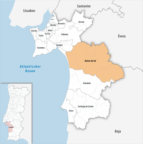
Alcácer do Sal is the seat of a district of the same name. The neighbors to the north are Palmela , Vendas Novas and Montemor-o-Novo ; in the northeast Viana do Alentejo , in the east Alvito , in the south Ferreira do Alentejo and Grândola , in the west Grândola (separated by an arm of the Sado delta ) and in the north-west, also separated by the Sado delta, Setúbal . Alcácer do Sal is part of the Alentejo Litoral , this is a sub-region in Portugal .
With the territorial reform in September 2013, the municipalities of Santiago , Santa Susana and Alcácer do Sal (Santa Maria do Castelo) were combined to form the new municipalities União das Freguesias de Alcácer do Sal (Santa Maria do Castelo e Santiago) e Santa Susana , so that the following are now four municipalities ( Freguesias ) belong to the Alcácer do Sal district:
| local community | Population (2011) |
Area km² |
Density of population / km² |
LAU code |
|---|---|---|---|---|
| Alcácer do Sal e Santa Susana | 9,033 | 888.35 | 10 | 150107 |
| Comporta | 1,268 | 150.54 | 8th | 150106 |
| São Martinho | 450 | 88.59 | 5 | 150105 |
| Torrão | 2,295 | 372.39 | 6th | 150104 |
| Alcácer do Sal district | 13,046 | 1,499.87 | 9 | 1501 |
Population development
| 1801 | 1849 | 1900 | 1930 | 1960 | 1981 | 1991 | 2001 | 2004 |
| 8,253 | 7,913 | 9,606 | 17,596 | 22,167 | 16,370 | 14,512 | 14,287 | 13,624 |
Town twinning
-
 France : Bondy (since 1999)
 -
 Mozambique : Mocuba (since 2000)
sons and daughters of the town
- Bernardim Ribeiro (1482–1552), writer
- Pedro Nunes (1502–1578), mathematician and astronomer
- Simão Rodrigues (1560–1629), mannerist painter
- Francisco Gentil (1878–1964), doctor and university professor
- João Mendes da Costa Amaral (1893–1981), politician and journalist, functionary of the Estado Novo regime
- Ruy Coelho (1889–1986), composer
- João Branco Núncio (1901–1976), bullfighter
- Leonor Alcácer (* 1961), actress and theater director
- Paulo Renato Valério Calado Rodrigues (* 1987), football player
literature
- Thomas G. Schattner (Ed.): Archaeological guide through Portugal (= cultural history of the ancient world . Vol. 74). Philipp von Zabern, Mainz 1998, ISBN 3-8053-2313-1 p. 159
Web links
- Official website ( Memento of October 31, 2015 in the Internet Archive )
- Photos by ALCÁCER DO SAL
- RailnetEurope.net shows pictures of the train station in Alcácer do Sal
Individual evidence
- ↑ a b www.ine.pt - indicator resident population by place of residence and sex; Decennial in the database of the Instituto Nacional de Estatística
- ↑ a b Overview of code assignments from Freguesias on epp.eurostat.ec.europa.eu
- ^ Publication of the administrative reorganization in the Diário da República gazette of January 28, 2013, accessed on March 16, 2014
- ↑ www.anmp.pt , accessed on February 3, 2013


