
Viana do Alentejo
| Viana do Alentejo | ||||||
|---|---|---|---|---|---|---|
|
||||||
| Basic data | ||||||
| Region : | Alentejo | |||||
| Sub-region : | Alentejo Central | |||||
| District : | Évora | |||||
| Concelho : | Viana do Alentejo | |||||
| Coordinates : | 38 ° 20 ′ N , 8 ° 0 ′ W | |||||
| Residents: | 2742 (as of June 30, 2011) | |||||
| Surface: | 94.7 km² (as of January 1, 2010) | |||||
| Population density : | 29 inhabitants per km² | |||||
| politics | ||||||
| Address of the municipal administration: | Junta de Freguesia de Viana do Alentejo R. Brito Camacho 17 7090-237 Viana do Alentejo |
|||||
| Viana do Alentejo County | ||||||
|
||||||
| Residents: | 5743 (as of June 30, 2011) | |||||
| Surface: | 393.67 km² (as of January 1, 2010) | |||||
| Population density : | 15 inhabitants per km² | |||||
| administration | ||||||
| Administration address: | Câmara Municipal de Viana do Alentejo Rua Brito Camacho, 13 7090-237 Viana do Alentejo |
|||||
| President of the Câmara Municipal: | Bernardino António Bengalinha Pinto | |||||
| Website: | www.cm-vianadoalentejo.pt | |||||


Viana do Alentejo is a small town ( Vila ) and a district ( Concelho ) in Portugal with 2742 inhabitants (as of June 30, 2011).
The district of Viana do Alentejo is one of only seven left in Portugal where the traditional animal bells of the Arte chocalheira are made. This Chocalhos bells were mentioned by the 2015 UNESCO in the list of urgent conservation need of the Intangible Cultural Heritage added.

history
The place already existed at the time of the Roman province of Lusitania and lasted until the end of the Moorish rule. After its extensive destruction during the Reconquista , it was repopulated in the 13th century by the Avis knight Gil Martins , who later became the Grand Master of the Order of Christ . Viana was officially mentioned for the first time in 1269 . Viana received its first town charter from King D Dinis , who had a castle built here around the same time in 1313 . The pottery caused an economic boom in the village, especially from the 17th century.
administration
circle
 Viana do Alentejo is the administrative seat of a district of the same name. The neighboring areas are (starting clockwise in the north): Montemor-o-Novo , Évora , Portel , Cuba , Alvito and Alcácer do Sal .
The following municipalities ( Freguesias ) are in the county of Viana do Alentejo:

| local community | Population (2011) |
Area km² |
Density of population / km² |
LAU code |
|---|---|---|---|---|
| Aguiar | 890 | 30.97 | 29 | 071303 |
| Alcáçovas | 2.111 | 268.00 | 8th | 071301 |
| Viana do Alentejo | 2,742 | 94.70 | 29 | 071302 |
| Viana do Alentejo County | 5,743 | 393.67 | 15th | 0713 |

Population development
| Population in the County of Viana do Alentejo (1801–2011) | |||||||||
|---|---|---|---|---|---|---|---|---|---|
| year | 1801 | 1849 | 1900 | 1930 | 1960 | 1981 | 1991 | 2001 | 2011 |
| Residents | 1 298 | 3,493 | 5065 | 7 814 | 9 237 | 6 188 | 5 720 | 5 615 | 5,743 |
Municipal holiday
- 13th January
Town twinning
-
 Brazil : Igarassu , Pernambuco State
-
Brazil : Porto Seguro , State of Bahia
-
Brazil : Viana (Maranhão) , Maranhão State

traffic
Viana do Alentejo is a stop on the Linha do Alentejo railway line , the train station is just outside the town.
National roads 254, 257, 383 and 384 cross at the site, via which Viana is connected to Portel 30 km to the east and its connection to the IP2 (here also European route 802).
sons and daughters of the town
- Luís Dias (1505–1542), shoemaker and Jewish pseudo-Messiah
- Fernão Cardim (1549–1625), Jesuit missionary in Brazil and author
- Duarte Lobo (1565–1646), composer
- Aleixo de Abreu (1568–1630), doctor, became internationally known for his publications on tropical diseases in Angola
- António Francisco Cardim (1596–1659), Jesuit missionary and author
- José Fernando de Sousa (1855–1942), military man, journalist, railway engineer and politician
gallery

Bar in the train station of Viana do Alentejo
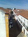
Looking into the streets of Viana

Senhora d'Aires church in Viana

Portal of the main church of Viana do Alentejo
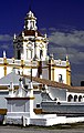
Senhora d'Aires church in Viana


.JPG)


Web links
- Map of the Freguesia Viana do Alentejo at the Instituto Geográfico do Exército
- Official website
Individual evidence
- ↑ a b www.ine.pt - indicator resident population by place of residence and sex; Decennial in the database of the Instituto Nacional de Estatística
- ↑ a b Overview of code assignments from Freguesias on epp.eurostat.ec.europa.eu
- ↑ www.ine.pt - indicator resident population by place of residence and sex; Decennial in the database of the Instituto Nacional de Estatística
- ↑ www.verportugal.net , accessed on August 24, 2013
- ↑ www.anmp.pt , accessed on August 24, 2013

Alandroal | Arraiolos | Borba | Estremoz | Évora | Montemor-o-Novo | Mora | Mourão | Portel | Redondo | Reguengos de Monsaraz | Vendas Novas | Viana do Alentejo | Vila Viçosa