Vila Viçosa
| Vila Viçosa | ||||||
|---|---|---|---|---|---|---|
|
||||||
| Basic data | ||||||
| Region : | Alentejo | |||||
| Sub-region : | Alentejo Central | |||||
| District : | Évora | |||||
| Concelho : | Vila Viçosa | |||||
| Coordinates : | 38 ° 47 ′ N , 7 ° 25 ′ W | |||||
| Residents: | 8319 (as of June 30, 2011) | |||||
| Surface: | 194.86 km² (as of January 1, 2010) | |||||
| Population density : | 43 inhabitants per km² | |||||
| Vila Viçosa district | ||||||
|
||||||
| Residents: | 8319 (as of June 30, 2011) | |||||
| Surface: | 194.86 km² (as of January 1, 2010) | |||||
| Population density : | 43 inhabitants per km² | |||||
| Number of municipalities : | 4th | |||||
| administration | ||||||
| Administration address: | Câmara Municipal de Vila Viçosa Praça da República 7160-207 Vila Viçosa |
|||||
| President of the Câmara Municipal: | Luís Caldeirinha Roma ( PS ) | |||||
| Website: | www.cm-vilavicosa.pt | |||||
Vila Viçosa is a small town ( Vila ) and a district ( concelho ) in Portugal with 8319 inhabitants (as of June 30, 2011). The place is known for the palace complex and for its significant marble deposits.
history
The area around Vila Viçosa was settled by the Celts and later by the Romans . The region was part of the Visigoth Empire and was later conquered by the Moors . In 1217 it came to the reconquest ( Reconquista ) and King Alfonso III. gave Vila Viçosa city rights in 1270. In the early 14th century, King Dionysius I had a castle built.
In 1461 the region came under the rule of the Bragança family . In 1507 the palace of the Bragança family was completed. When Duke João von Bragança was proclaimed King John IV of Portugal in 1640 , the Bragança family moved to Lisbon and only used the huge palace in Vila Viçosa as a summer residence. With that, Vila Viçosa lost its importance in terms of big politics.
administration

The district with its municipalities after the 2013 administrative reform
|
circle
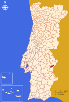
Vila Viçosa is the administrative seat of a district of the same name ( concelho ). The neighboring areas are (starting clockwise in the north): Elvas , Alandroal , Redondo and Borba .
With the territorial reform in September 2013 , the municipalities of Conceição and São Bartolomeu were merged to form the new municipality of Nossa Senhora da Conceição e São Bartolomeu . Since then, the district has consisted of the following four parishes ( Freguesias ):
| local community | Population (2011) |
Area km² |
Density of population / km² |
LAU code |
|---|---|---|---|---|
| Bencatel | 1,679 | 36.21 | 46 | 071401 |
| Ciladas | 1,071 | 107.51 | 10 | 071402 |
| Nossa Senhora da Conceição e São Bartolomeu | 5,023 | 33.19 | 151 | 071406 |
| Pardais | 546 | 17.95 | 30th | 071404 |
| Vila Viçosa district | 8,319 | 194.86 | 43 | 0714 |
Population development
| Population in Vila Viçosa County (1801–2011) | |||||||||
|---|---|---|---|---|---|---|---|---|---|
| 1801 | 1849 | 1900 | 1930 | 1960 | 1981 | 1991 | 2001 | 2011 | |
| 5,697 | 5,821 | 7.163 | 8,444 | 9,974 | 8,546 | 9,068 | 8,871 | 8,319 | |
Municipal holiday
- August 16
economy
The mining of marble and its processing is the most important branch of the economy in the district. Tourism is another important economic factor. Agriculture should also be mentioned.
sons and daughters of the town
- Fadrique de Portugal († 1539), Archbishop of Saragossa, Viceroy of Catalonia
- Martim Afonso de Sousa (around 1500–1571), noble seafarer and military, first governor of Brazil
- Públia Hortênsia de Castro (1548–1595), humanist writer and philosopher
- Francisco de Lucena (1578–1643), executed diplomat and politician, Prime Minister 1640–1642
- John IV (1604–1656), Portuguese king 1640–1656
- António de Oliveira de Cadornega (1623–1690), military and historian, who worked mainly in Angola
- Teodósio de Bragança (1634–1653), Prince of Brazil, premature heir to the throne, son of John IV.
- Francisco Inocêncio de Sousa Coutinho (1726–1780), military and colonial administrator, Governor of Angola 1764–1772
- Henrique Pousão (1859-1884), painter
- Florbela Espanca (1894–1930), writer
- Bento de Jesus Caraça (1901–1948), mathematician, university professor and communist activist
- António Eduardo Lobo Vilela (1902–1966), geographer, educator, author and politician
- Túlio Espanca (1913–1993), art historian and author, cousin Florbela Espancas
- Nuno Portas (* 1934), architect
- Fernando Matos Silva (* 1940), film director
literature
- Jessica Hallett, Nuno Senos: De Todas as Partes do Mundo. O Património do 5.º Duque de Bragança, D. Teodósio I. Tinta da China, Lisbon 2018, ISBN 978-989-671-177-1 (Portuguese).
Web links
Individual evidence
- ↑ a b www.ine.pt - indicator resident population by place of residence and sex; Decennial in the database of the Instituto Nacional de Estatística
- ↑ a b Overview of code assignments from Freguesias on epp.eurostat.ec.europa.eu
- ^ Publication of the administrative reorganization in the Diário da República gazette of January 28, 2013, accessed on March 16, 2014


