Mourão
| Mourão | ||||||
|---|---|---|---|---|---|---|
|
||||||
| Basic data | ||||||
| Region : | Alentejo | |||||
| Sub-region : | Alentejo Central | |||||
| District : | Évora | |||||
| Concelho : | Mourão | |||||
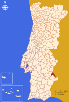
| Coordinates : | 38 ° 23 ′ N , 7 ° 21 ′ W | |||||
| Residents: | 1768 (as of June 30, 2011) | |||||
| Surface: | 135.22 km² (as of January 1, 2010) | |||||
| Population density : | 13 inhabitants per km² | |||||
| Mourão district | ||||||
|
||||||
| Residents: | 2663 (as of June 30, 2011) | |||||
| Surface: | 278.63 km² (as of January 1, 2010) | |||||
| Population density : | 9.6 inhabitants per km² | |||||
| Number of municipalities : | 3 | |||||
| administration | ||||||
| Administration address: | Câmara Municipal de Mourão Praça da República, 20 7240-233 Mourão |
|||||
| President of the Câmara Municipal: | José Manuel Santinha Lopes ( PS ) | |||||
| Website: | www.cm-mourao.pt | |||||
Mourão is a small town ( Vila ) and a district ( concelho ) in Portugal with 1768 inhabitants (as of June 30, 2011).
geography
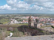
The place is on the eastern bank of the Guadiana , facing Spain , at the upper end of the Alqueva reservoir . It is 6.5 km to the eastern Spanish border and 56 km to the western district capital of Évora.
history
People have settled on the Guadiana since prehistory , as testified by megalithic structures , ceramic finds and wall paintings . The most important Roman building in the district was the fortress Castelo da Lousa in the municipality of Luz, which is now sunk in the Alqueva dam. Not much is known about the time up to the Middle Ages , especially since archaeological excavation sites are mostly located in the reservoir. The current location only appears in documents on the demarcation between the Kingdom of Portugal, which has been independent since 1140, and the Kingdom of Castile . He received his first town charter in 1226 from the Hospitaller Order , who had received the area during the Reconquista .
King D. Dinis confirmed the town charter in 1296 . After legal uncertainties regarding Spanish claims, D. Dinis offered the place for sale and Mourão came to a Spanish merchant in 1313 . After the latter had not raised the purchase price, the king offered the place up for sale again and a merchant from Monsaraz bought the place. King Dinis later forced the return of the place at the purchase price. In the Portuguese Revolution of 1383 Mourão stood on the side of Portugal, whereupon it suffered severe damage by Castilian troops.
After the governor had decided in favor of the personal union with Spain in 1580 , Mourão supported the events in 1640 that led to the war of restoration and the renewed independence of Portugal. As a result, it was again destroyed by Spanish troops who were able to conquer the place in 1657 until Portuguese forces liberated it again in the same year.
In the earthquake of Lisbon in 1755 , the place experienced new destruction, so that it was partially redesigned and rebuilt. In the course of the administrative reforms after the Liberal Revolution in 1822 , the Mourão district was dissolved in 1853 and incorporated into Monsaraz before becoming independent again in 1861 .
Culture and sights
The architectural monuments include two social housing districts from the late phase of the Estado Novo regime (1969), the Estação Fronteiriça de São Leonardo border station from 1928, and a traditional olive oil mill. Some sacred buildings are also listed, including the single-nave baroque church Igreja da Misericórdia de Mourão .
The historic town center is also a listed building as a whole.
Due to the fact that it was cut off from the rest of the country, the town lagged behind in its economic development. On the other hand, however, this favored the preservation of the natural landscapes in the district. Bird watching is practiced here.
administration
circle
Mourão is the seat of a district of the same name that borders on Spain to the east . The neighboring districts are (starting clockwise in the north): Alandroal , Barrancos , Moura and Reguengos de Monsaraz .
The following municipalities ( Freguesias ) are in the Mourão district:
| local community | Population (2011) |
Area km² |
Density of population / km² |
LAU code |
|---|---|---|---|---|
| Granja | 605 | 92.56 | 7th | 070801 |
| Luz | 290 | 50.85 | 6th | 070802 |
| Mourão | 1,768 | 135.22 | 13 | 070803 |
| Mourão district | 2,663 | 278.63 | 10 | 0708 |
Population development
| Population in Mourão County (1801–2011) | |||||||||
|---|---|---|---|---|---|---|---|---|---|
| 1801 | 1849 | 1900 | 1930 | 1960 | 1981 | 1991 | 2001 | 2011 | |
| 2 615 | 2,341 | 3 855 | 5 064 | 5 815 | 3 487 | 3 273 | 3 230 | 2,666 | |
Municipal holiday
- February 2nd
sons and daughters of the town
- Manuel da Costa (1601–1667), Jesuit university professor and author
- Marco Paulo (* 1945), entertainment singer
- Hernâni Neves (born 1963), football player
Web links
- Map of the Freguesia Mourão at the Instituto Geográfico do Exército
- Official website
Individual evidence
- ↑ a b www.ine.pt - indicator resident population by place of residence and sex; Decennial in the database of the Instituto Nacional de Estatística
- ↑ a b Overview of code assignments from Freguesias on epp.eurostat.ec.europa.eu
- ↑ www.ine.pt - indicator resident population by place of residence and sex; Decennial in the database of the Instituto Nacional de Estatística
- ↑ History page of the district website ( memento of the original from October 21, 2014 in the Internet Archive ) Info: The archive link was inserted automatically and has not yet been checked. Please check the original and archive link according to the instructions and then remove this notice. , accessed July 14, 2013
- ↑ www.verportugal.net , accessed on July 14, 2013
- ↑ www.monumentos.pt , accessed on July 14, 2013
- ↑ ditto
- ↑ ditto
- ↑ ditto
- ↑ www.avesdeportugal.info , accessed July 14, 2013


