Grândola
| Grândola | ||||||
|---|---|---|---|---|---|---|
|
||||||
| Basic data | ||||||
| Region : | Alentejo | |||||
| Sub-region : | Alentejo Littoral | |||||
| District : | Setubal | |||||
| Concelho : | Grândola | |||||
| Coordinates : | 38 ° 11 ′ N , 8 ° 34 ′ W | |||||
| Residents: | 10,660 (as of June 30, 2011) | |||||
| Surface: | 363.87 km² (as of January 1, 2010) | |||||
| Population density : | 29 inhabitants per km² | |||||
| Grândola district | ||||||
|
||||||
| Residents: | 14,826 (as of June 30, 2011) | |||||
| Surface: | 825.93 km² (as of January 1, 2010) | |||||
| Population density : | 18 inhabitants per km² | |||||
| Number of municipalities : | 4th | |||||
| administration | ||||||
| Administration address: | Câmara Municipal de Grândola R. Dr. José Pereira Barradas 7570-281 Grândola |
|||||
| President of the Câmara Municipal: | Graça Guerreiro Nunes (independent candidate on the PS list) | |||||
| Website: | www.cm-grandola.pt | |||||
Grândola [ ˈɡɾɐ̃dulɐ ] is a district town ( Vila ) and a district ( concelho ) in the Setúbal district with 10,660 inhabitants (as of June 30, 2011). It gained fame as the namesake of the song Grândola, Vila Morena , which served as the slogan of the Carnation Revolution in 1974 .
history
The human settlement of the area around Grândola can be traced at the 40 archaeological points that still exist today and left us with the period between the Stone Age and the Roman Empire . The first settlers in this area were Celts , who probably arrived here by boats from the northern areas of Galicia . Witnesses to this time are scattered throughout the area and megalithic tombs.
From the Roman era there are excavations of bath houses and thermal baths 2 km outside the village of Grândola . The ruins of the port of Cetóbriga on the Troia peninsula, the largest pre-industrial fish processing complex known to date in the western Mediterranean region, date from the same period . After it was founded in the 1st century AD, activities continued here until the end of the 4th century. The Roman inhabitants lived practically in all parts of the present-day area of the district of Grândola. A center of Roman military power was in the area of the city of Santiago do Cacém and the seaport in Alcácer do Sal , which are in the direct vicinity of Grândola. After the Romans, the Teutons came to what is now Portugal around 410 , followed by the Visigoths around 600 . Around the year 700, large parts of the Iberian Peninsula were conquered by the Arabs , who ruled in the area of Grândola with headquarters in Alcácer do Sal until the 12th century. The Moorish influence has left its mark on neither the culture nor the architecture of this area that has prevailed to this day.
Only in the 12th century were the Arabs by the Christians coming from the north under King Alfonso III. finally expelled. The area around Grândola became part of the first Portuguese kingdom.
In 1492, Grândola had only 135 inhabitants, while around 810 inhabitants with 180 campfire sites lived in what is now the district. The first register of residents dates from 1527 and mentions 1103 residents with 245 fireplaces. Under the Moors and afterwards, Grândola was always dependent on Alcácer do Sal . Due to a request of the residents to the then King Dom João III. Grândola received its independence as a city on October 22, 1544.
With this change from village to town, the geographical district with Grândola as its center began to develop. Administratively, a dependency on the city of Setúbal developed , which today is the capital of the district of the same name, to which Grândola belongs. In 1727 the hospice of Nossa Senhora dos Anjos was founded by the Augustinians and in 1890 Grândola became the district capital, which it remains to this day.
At the beginning of the 20th century, industrial activities were added to agricultural activities through the exploitation of two mines (Canal Caveira and Lousal ), which led to industrial workers settling in the area. In addition, these mines led to rapid economic growth in the district, as well as an expansion of local communications and transportation routes. In 1926 the rail connection was expanded. In the 1930s, the Salazar dictatorship made Grândola part of the nation's breadbasket. The cultivation of grain was promoted, so that in 1950 the population had grown to 21,370 inhabitants. After that, in the 1960s, an exodus from the countryside to the two cities of Setúbal and Lisbon began and the population decreased again. The two mines were also closed due to a lack of profitability. Only in the 1970s did the economic situation stabilize again; after the Carnation Revolution , the city grew at a rapid pace. Smaller industrial complexes were added and tourism also plays a greater role in the Grândola district today.
Grândola is located in the Alentejo region , where many farm workers lived in the 19th and 20th centuries. Typical of the region were choirs , which were also sung at work. In the style of these chants, the singer José Afonso composed his song Grândola, Vila Morena , which on the night of April 25, 1974 was the starting signal for the Carnation Revolution and made the name of the city known worldwide. Coming from Lisbon, you can see a monument in the entrance to the town, which shows the text of the song.
meaning
Today, Grândola is an up-and-coming district town with an old market building as well as a large open-air market called “Feira” once a month. Once a year at the end of August, a large agricultural fair with a summer festival and cultural program takes place on the “Feira” outdoor area. Grândola has its own school center, library, swimming pool and multi-purpose sports hall, as well as an extensive city park in the center of the village. There is an older town center around the market hall and various new districts around the town that are constantly growing. Grândola has its own train station and the Intercity from / to Lisbon or Faro stops here several times a day . There is also a central bus station. It is approx. 30 km from Grandola to the Atlantic coast. Grândola has several accommodation options and restaurants for travelers and holidaymakers.
Natural area of the Serra de Grandola
The Serra de Grândola is a coastal mountain range with a height of 383 meters. The coastal mountains are located in the Alentejo Litoral and run parallel to the coast in a north-south direction. The area takes its name from the county seat of Grândola, from where it extends to the city of Santiago do Cacém . The coastal mountains consist of extensive cork oak forests , which are crossed by numerous streams and rivers. In the center of the Serra de Grandola is the town of Santa Margarida da Serra , which belongs to the district of Grândola. The place is picturesquely embedded in the nature reserve. In the village you can rent a renovated original Alentejan farmhouse.
administration
circle
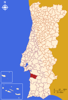
Grândola is the administrative seat of a district of the same name. The neighboring areas are (starting clockwise in the north): Alcácer do Sal , Ferreira do Alentejo , Santiago do Cacém , the Atlantic Ocean and Setúbal . Grandola is part of the Alentejo Litoral , a sub-region in Portugal .
With the territorial reform in September 2013, the municipalities ( freguesias ) Grândola and Santa Margarida da Serra were merged to form the new municipality União das Freguesias de Grândola e Santa Margarida da Serra . Since then, the district has consisted of the following four municipalities:
| local community | Population (2011) |
Area km² |
Density of population / km² |
LAU code |
|---|---|---|---|---|
| Azinheira dos Barros e São Mamede do Sádão | 704 | 172.52 | 4th | 150501 |
| Carvalhal | 1,630 | 82.00 | 20th | 150505 |
| Grândola e Santa Margarida da Serra | 10,834 | 416.25 | 26th | 150506 |
| Melides | 1,658 | 155.16 | 11 | 150503 |
| Grândola district | 14,826 | 825.93 | 18th | 1505 |
as well as the nature reserve of
Population development
| Population in the district of Grândola (1801–2011) | |||||||||
|---|---|---|---|---|---|---|---|---|---|
| 1801 | 1849 | 1900 | 1930 | 1960 | 1981 | 1991 | 2001 | 2011 | |
| 3463 | 2528 | 7539 | 13,370 | 21,060 | 16,042 | 13,767 | 14,901 | 14,826 | |
Town twinning
-
 Cape Verde : Tarrafal (since 2007)
 -
 East Timor : Lautém (since 2011)
 -
 Portugal : Santarém (since 2006)
 -
 Brazil : Maracanaú (in preparation)
Cooperation Agreement:
Web links
- Map of the Freguesia Grândola at the Instituto Geográfico do Exército
- City administration website (Portuguese)
- RailFanEurope.net shows pictures of the Grandola train station
Individual evidence
- ↑ www.ine.pt - indicator resident population by place of residence and sex; Decennial in the database of the Instituto Nacional de Estatística
- ↑ a b Overview of code assignments from Freguesias on epp.eurostat.ec.europa.eu
- ↑ www.ine.pt - indicator resident population by place of residence and sex; Decennial in the database of the Instituto Nacional de Estatística
- ^ Publication of the administrative reorganization in the Diário da República gazette of January 28, 2013, accessed on March 16, 2014
- ↑ Municípios Portugueses: Geminações de Cidades e Vilas , accessed on January 7, 2018.
- ↑ www.anmp.pt , accessed on February 3, 2013


