Volp
| Volp | ||
|
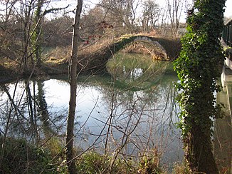
The river in the estuary with the Pont de Diable |
||
| Data | ||
| Water code | FR : O06-0400 | |
| location | France , Occitania region | |
| River system | Garonne | |
| Drain over | Garonne → Atlantic Ocean | |
| source | in the parish of Lescure, 43 ° 1 ′ 38 ″ N , 1 ° 15 ′ 44 ″ E |
|
| Source height | approx. 550 m | |
| muzzle | in the municipality of Gensac-sur-Garonne in the Garonne Coordinates: 43 ° 12 ′ 20 ″ N , 1 ° 6 ′ 37 ″ E 43 ° 12 ′ 20 ″ N , 1 ° 6 ′ 37 ″ E |
|
| Mouth height | approx. 230 m | |
| Height difference | approx. 320 m | |
| Bottom slope | approx. 8 ‰ | |
| length | 40 km | |
The Volp is a river in France that runs in the Occitania region . It rises in the Pyrénées Ariégeoises Regional Nature Park , in the municipality of Lescure , initially drains in a westerly direction, then turns to north and northwest and, after a total of 40 kilometers, flows into the reservoir area of the Retenue de Labrioulette , in the municipality of Gensac-sur-Garonne , as a right tributary in the Garonne . In the municipality of Montesquieu-Aventès, the Volp seeps away underground and only comes to the surface after around 800 meters as a karst spring . On its way, the river crosses the Ariège and Haute-Garonne departments .
