
Volta (river)
| Volta | ||
 |
||
| Data | ||
| location |
sources in Burkina Faso |
|
| River system | Volta | |
| origin | Confluence of Black and White Volta 8 ° 38 ′ 55 ″ N , 0 ° 58 ′ 57 ″ W |
|
| muzzle |
Gulf of Guinea ( Atlantic ) Coordinates: 5 ° 46 ′ 16 " N , 0 ° 40 ′ 23" E 5 ° 46 ′ 16 " N , 0 ° 40 ′ 23" E |
|
| Mouth height |
0 m
|
|
| length | 1500 km | |
| Catchment area | 398,390 km² | |
| Discharge at the Senchi A Eo gauge: 394,995 km² Location: 111 km above the mouth |
NNQ (min. Month Ø) MNQ 1936–1979 MQ 1936–1979 Mq 1936–1979 MHQ 1936–1979 HHQ (max. Month Ø) |
9 m³ / s 268 m³ / s 1106 m³ / s 2.8 l / (s km²) 3833 m³ / s 12,490 m³ / s |
| Left tributaries | Daka , Oti (Pendjari), Dayi | |
| Right tributaries | Pru , Senne , Obosum , Afram | |
| Reservoirs flowed through | Volta lake | |
| Residents in the catchment area | 23,924,622 (2010) | |
 The Volta south of the Akosombo Dam . Adomi Bridge |
||
The Volta is a river in the states of Burkina Faso and Ghana in West Africa . Together with the Black Volta as the main source river, the Volta has a length of 1500 km.
The former French colony of Upper Volta , today's Burkina Faso, was named after the river . The flag of Upper Volta also referred to the Volta. The river itself got its name from Portuguese explorers, perhaps because it represented the furthest point of their explorations or because of its winding course: volta means "turn" in Portuguese.
course

The Volta has three source rivers, which are called Black Volta (Mouhoun), Red Volta (Nazinon) and White Volta (Nakambé). All three have their source in Burkina Faso. Near the large trading city of Salaga in Ghana, the black and white volta unite to form the volta. The Rote Volta joins the White Volta beforehand.
The main river is dammed up to Lake Volta at Akosombo Dam . The confluence of the White and Black Volta is now flooded by the reservoir, as are the mouths of practically all of its relevant tributaries. Its most important tributary is the Oti (Pendjari), which is sometimes also referred to as the fourth source river. In addition there are Daka , Pru and Afram to mention.
The Volta flows in a south-easterly direction. Forming the Ada lagoon on the right and connected to the Keta lagoon on the left, it flows into the Gulf of Guinea via a large bar with strong surf (Kalema) .
The enormous breakers on the shallows of its mouth used to occur (i.e. before the construction of the Akosombo Dam in the 1960s) with seasonal fluctuations in the interaction with tidal currents and winds. At that time, the tides on the seashore had an effect up to the level of Malfi , which is about 36 km upstream from the mouth.
Like the Nile and Niger , in the past the Volta had its annual flood area, where it left fertile soil. In particular, the area of the lowest course of the river used to be a center of table salt production.
Catchment area
The catchment area of the Volta is divided as follows (based on 394,000 km²):
| States | Catchment area of the state in [km²] | Percent of the area of the catchment area | Percent of the country's area |
|---|---|---|---|
| Mali | 9,496 | 2.4 | 0.8 |
| Burkina Faso | 183,000 | 46.4 | 66.8 |
| Benin | 16,000 | 4.1 | 14.2 |
| Togo | 26,700 | 6.7 | 47.0 |
| Ivory Coast | 7,000 | 1.8 | 2.2 |
| Ghana | 152,000 | 38.6 | 63.7 |
| total | 394.196 | 100 |
Hydrometry
The flow rate of the Volta was measured over 43 years (1936–1979) in Senchi about 110 kilometers upstream from the mouth (in m³ / s).

gallery
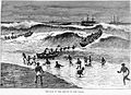
The surf on the shallows in front of the Volta estuary, depiction from the 2nd half of the 19th century.

Customs post at Chease am Volta 1910

Nakambé (White Volta) east of Ouagadougou
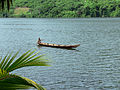
Boat on the Volta

The Voltasee

View of the Nazinon (Roter Volta) in the Kaboré-Tambi National Park


Web links
further reading
- IB Sutton, The Volta river salt trade: the survival of an indigenous industry , in: Journal of African History , 22 (1), 1981, pp. 43-61
See also
Individual evidence
- ↑ - Basin Authority ( Memento of the original from November 11, 2014 in the Internet Archive ) Info: The archive link was inserted automatically and has not yet been checked. Please check the original and archive link according to the instructions and then remove this notice. (PDF; 4.5 MB)
- ↑ GRDC - The Volta in Senchi
- ↑ IWMI - The Volta River Basin (2005)
- ^ Volta etymology
- ^ FAO - The Volta River basin