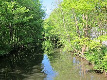
Würm Canal
The Würm Canal is part of the north Munich canal system .
geology
The canal connects the Würm with Schleissheim Palace . It begins in Karlsfeld ( 48 ° 12 ′ 51 ″ N , 11 ° 27 ′ 40 ″ E ; 494 m above sea level ), runs in parts through the Munich area Urban area and after about ten kilometers flows into the Mühlbach in the southern area of the castle park ( 48 ° 14 ′ 54 ″ N , 11 ° 33 ′ 20 ″ E ; 485 m above sea level ).
Tributaries
- Würm (Amper) , main tributary
- Schwabenbächl (as the lower reaches of the Hartmannshofer Bach ), right
- Feldmochinger Mühlbach , right
history
In addition to the canals in Schleißheim Palace Park, the Würm Canal feeds the Kalterbach and Schwebelbach , which branch off from it to the north. From the south the Schwabenbächl and Feldmochinger Mühlbach flow into the Würm Canal , and the Würmhölzlgraben runs under the canal.
A large part of the Würm water is diverted through the Würm Canal in the direction of Oberschleißheim. A first Würm Canal was built in 1601 to supply the Schwaige Wilhelm V, an agricultural estate near Schleissheim, with additional water from the Würm. In 1690/91 Max Emanuel had a new, straight canal built further north. Together with the Isar-Schleissheim Canal, the Würm Canal was and is the main water supplier for the Schleissheim palace complex and used to be a transport route for building materials. The wooded area along the canal is a registered biotope, the canal itself is a listed building as part of the Schleißheim Canal System .

