Włosienica (High Tatras)
| Włosienica | ||
|---|---|---|
|
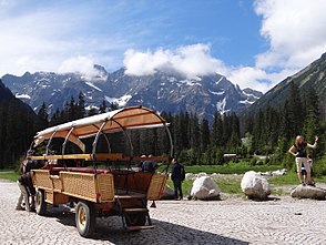
Horse-drawn carriages on the Włosienica mountain pasture |
||
| location | Lesser Poland Voivodeship , Poland | |
| Mountains | High Tatras , Tatras , Carpathians | |
| Geographical location | 49 ° 12 '50 " N , 20 ° 4' 50" E | |
|
|
||
| Waters | Rybi Potok | |
| climate | High mountain climate | |
The Alm Włosienica is an alpine pasture in the Dolina Rybiego Potoku valley in the Polish High Tatras in the Lesser Poland Voivodeship .
history
The pasture was built in the 17th century below the Meerauge mountain lake and has been near the Tatra National Park since 1954 . The southern end of the Oswald-Balzer-Weg is on the Alm . This is the terminus of the horse-drawn carriages that leave from the Palenica Białczańska mountain pasture .
tourism
Two hiking trails lead through the Alm.
- ▬ A red marked trail leads from Zakopane district Toporowa Cyrhla to the peak Rysy . The hiking trail partly follows the Oswald-Balzer-Weg .
- ▬ A red hiking trail leads from the Palenica Białczańska pasture around the Meerauge mountain lake.
literature
- Zofia Radwańska-Paryska, Witold Henryk Paryski, Wielka encyklopedia tatrzańska , Poronin, Wyd. Górskie, 2004, ISBN 83-7104-009-1 .
- Tatry Wysokie słowackie i polskie. Mapa turystyczna 1: 25.000, Warszawa, 2005/06, Polkart ISBN 83-87873-26-8 .
Web links
Commons : Włosienica (High Tatras) - collection of images, videos and audio files

