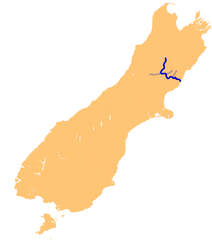
Waiau River (Canterbury)
| Waiau River | ||
|
River system of the Waiau River |
||
| Data | ||
| location | Spenser Mountains , Hurunui District , Canterbury Region , New Zealand | |
| River system | Waiau River (Canterbury) | |
| source | Spenser Mountains 42 ° 7 ′ 13 ″ S , 172 ° 38 ′ 32 ″ E |
|
| Source height | 1680 m | |
| muzzle |
Pacific Ocean Coordinates: 42 ° 46 ′ 34 " S , 172 ° 22 ′ 36" E 42 ° 46 ′ 34 " S , 172 ° 22 ′ 36" E |
|
| Mouth height | 0 m | |
| Height difference | 1680 m | |
| Bottom slope | 10 ‰ | |
| length | 165 km | |
| Catchment area | 3310 km² | |
| Left tributaries | Leader River | |
| Right tributaries | Ada River , Hope River | |
| Communities | Hanmer Springs , Waiau , Parnassus | |
|
Waiau River upstream from the Waiau Ferry Bridge in Hanmer Springs seen from |
||
The Waiau River is a 165 km long river in the Hurunui District , in the north of the Canterbury region on the South Island of New Zealand .
geography
The Waiau River is created by the outflow of Lake Thompson below the Thompson Pass in the Spenser Mountains at an altitude of about 1680 m . After the outflow and a right turn, the river first flows in a southerly direction, and then after about 58 km and the confluence with the Hope River flows in an easterly direction. South of Hanmer Springs the river turns south again for around 15 km and then meanders in wide and later in smaller arcs towards the east of the Pacific coast . The Waiau River then flows into the Pacific Ocean around 10 km northeast of Cheviot .
On its way, the Waiau River flows through the southern part of the Hanmer Plain and, after passing through some gorges, the northern part of the Amuri Plain ( Culverden Plain ). At 3310 km², the river has the second largest catchment area of all rivers in North Canterbury .
The Waiau River was originally called the Dillon or Waiau-ua River . The short form of the Māori name then caught on.
use
The river is good for fishing for almost its entire length. Brown trout and, depending on the season, lake trout and salmon in the lower course can be caught.
In the section of the river near Hanmer Springs and south of it in the ravines that's rafting ( rafting ) very popular.
See also
- Waiau River - List of other rivers of the same name in New Zealand
literature
- Robert Logan : Waimakariri: The story of Canterbury's river of cold rushing water - an illustrated history . Self-published, Canterbury 1987, ISBN 0-473-00520-4 , pp. 6 (English).
- Donald Rowe Gregg : Waiau River, North Canterbury . In: Alexander Hare McLintock (Ed.): An Encyclopaedia of New Zealand . Whangarei 1966 (English, online [accessed February 7, 2017], last edited April 22, 2009).
Web links
Individual evidence
- ↑ a b c Measurement of the length and the determination of the coordinates of the source and the mouth by Google Earth.
- ↑ a b Waiau River Catchment . Land Air Water Aoteaora (LAWA), accessed February 7, 2017 .
- ↑ Topo250 maps - Reefton - Wairau River - Lake Sumner . Land Information New Zealand , accessed February 7, 2017 .
- ^ Gregg : Waiau River, North Canterbury . 2009.
- ^ Waiau River Fishing . nzfishing.com , accessed February 7, 2017 .
- ↑ River Guide - Lower Waiau River . New Zealand Rafting Association , accessed February 7, 2017 .


