
Waitahuna
| Waitahuna | ||
| Geographical location | ||
|
||
| Coordinates | 45 ° 59 ′ S , 169 ° 46 ′ E | |
| Region ISO | NZ-OTA | |
| Country |
|
|
| region | Otago | |
| District | Clutha District | |
| Ward | Lawrence - Tuapeka Ward | |
| Residents | few | |
| height | 130 m | |
| Post Code | 9593 | |
| Telephone code | +64 (0) 3 | |
| Photography of the place | ||
 Boyldon Street from Sunderland Street , looking north |
||

Waitahuna is a settlement in the Clutha District of the Otago regionon the South Island of New Zealand .
Origin of name
In the Māori language , the name of the settlement consists of “ wai ” for “water” and “ tahuna ” for the name of a chief of the Ngāi Tahu tribe .
geography
The settlement is located around 22 km northwest of Milton and around 28 km north of Balclutha in the Waitahuna River valley . About 2 km to the east is Waitahuna Gully , where gold was mined during the gold rush in Otago . The New Zealand State Highway 8 runs through Waitahuna and connects the settlement to the northwest with Lawrence , Roxburgh and Alexandra and joins the New Zealand State Highway 1 to the southeast .
history
At the beginning of the 20th century, the settlement made a living from farming and gold mining in the nearby Waitahuna Gully . In the settlement itself, the search for gold took place in the 1940s and after an almost 70-year hiatus, the Christchurch- based company Maruia Mining applied for the prospecting rights for a new gold search in the Waitahuna area in August 2015 .
The place was briefly a railway terminus after the section of the later Roxburgh Branch named branch line of the Main South Line from Clarksville was opened on January 22, 1877. A little more than two months later, the next section to Lawrence was inaugurated. The settlement was served by passenger trains until September 4, 1936, after which it was only served by freight trains until the line was closed on June 1, 1968. The storage shed, the station building and the men's toilets have been preserved on the site of the former station.
The place also has a suspension bridge built around 1905/06 over the Waithuna River .
Education
With the Waitahuna School, the settlement has a primary school with grades 1 to 6. In 2015, 21 students attended the school. The school was founded in 1875 at the time of the gold rush when the school was founded as the Waitatiuna Public School and at that time had three rooms, including a library.
Photo gallery
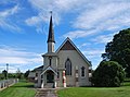
Waitahuna Presbyterian Church

Waitahuna War Memorial Hall


literature
- Waitahuna . In: The Cyclopedia of New Zealand . Otago and Southland Provincial District - Volume IV . Cyclopedia Company Ltd , Christchurch 1905 (English, online [accessed February 9, 2017]).
- Helga Neubauer: Waitahuna . In: The New Zealand Book . 1st edition. NZ Visitor Publications , Nelson 2003, ISBN 1-877339-00-8 , pp. 828 .
Web links
Individual evidence
- ^ Neubauer: Waitahuna . In: The New Zealand Book . 2003, p. 828 .
- ↑ Topo250 maps . Land Information New Zealand , accessed September 6, 2017 .
- ↑ a b Waitahuna . In: The Cyclopedia of New Zealand . 1905.
- ↑ Hamish MacLean : Miners to dig in ancient riverbed . In: Otago Daily Times . Allied Press , August 3, 2015, accessed September 6, 2017 .
- ^ Waitahuna School . Education Review Office , accessed September 6, 2017 .