
Wakenitz wall


The Wakenitzmauer is a street in Lübeck's old town .
location
The approximately 750 meter long Wakenitz wall in the northeastern part of the old town island, the Jakobi Quartier , begins at the lower end of Kaiserstraße , where a gate in the medieval city wall leads to the Ida Boy Ed garden . It leads south, tracing the course of the old city wall, which in turn followed the Wakenitz bank line until the Elbe-Lübeck Canal was built in 1896–1900.
In a square-like extension, Kleine Gröpelgrube , Rosenstrasse and Rosenpforte initially meet the Wakenitzmauer in a star shape , then the Große Gröpelgrube and Steinstrasse come in from the west, then the Wakenitzmauer is crossed one after the other from Far Lohberg , Glockengießerstrasse and Hundestrasse before it becomes a dead end next to a preserved short section of the city wall ends butt in front of a half-timbered house.
history
For a long time, the Wakenitz wall was not regarded as a street that belonged together and accordingly did not have a uniform name, although Bei der Mauer and similar names were used as vague generic terms in linguistic usage.
- The short stretch south of Hundestrasse, which today forms the end of the street as a cul-de-sac, has been called Im Sack since 1584 .
- The section between Hundestrasse and Glockengießerstrasse was known as Rothbars Mauer .
- The stretch from Glockengießerstraße to Weiten Lohberg is mentioned in a document in 1287 with the Latin name Nova civitas (New City). In 1353 the name Nyenstrate (Neue Straße) is recorded, in 1597 Up der Nienstat (Auf der Neustadt).
- The stretch of road between Weitem Lohberg and Großer Gröpelgrupe has been called the Schobandsmauer since 1614 , after an expression for the urban skinner who lived here.
- The small square at the meeting point with the Kleiner Gröpelgrube is occupied in 1480 as By dem Rosenthorn (near the rose tower) after a tower of the city fortifications located here.
- The section up to Kaiserstraße has had numerous names over the years. In 1449 Apud murum inter plateam Rosae et turrim Caesaris (At the wall between Rosenstrasse and Kaiserturm), 1446 By the Kaiserthorme and 1571 By the Kaisermuhren referred to the imperial tower of the city wall . The hemp spinners and rope makers practicing their craft here were the inspiration for the names Hempfspinnermuhren (1480), Hennespinnerstrate (1555) and By den Repermuren (1572). The name By der Schafferie , recorded in 1536, referred to the Schafferei, the home of the town's Schaffer, an administrative officer.
In 1884 the entire street was merged and received its name, which is still valid today. In 1903 the city wall was broken through with a gate at the beginning of the Wakenitz wall and the street was extended in an ascending arc up to the Burgtorbrücke. Since 1952, this short section has not been part of the Wakenitz wall, but has been an independent street as the Ida Boy Ed garden .
The Wakenitz wall ran directly on the inside of the city wall; accordingly, only the west side of the street is lined with historical houses, while on the east side there are more recent buildings. To the north are the buildings of the early 20th century, which were built on the former Schaffereigelände after 1903, to the south, then mainly the backs of commercial establishments and residential buildings from the late 19th century to the 1970s.
Buildings
Under conservation building are no. 1 (= Kanalstraße 2), 1a-9a, 2-6, 8-14, 16, 17, 22, 24-26, 27, 28/30, 29, 32/34, 36 ( = Kleine Gröpelgrube 15), 38/40, 42 (= Rosenstrasse (Lübeck) 1 and 3), 44–54, 56 and 58, 60, 62–70, 72 and 74, 76, 78, 80, 86, 88, 90, 96 and 98, 102, 104 and 106, 108, 114 (= Weiter Lohberg 20), 118, 130, 132 ( Kattundrucker-Gang , Haus 5–8), 134–140, 142, 144 and 146, 150 and 152, 156 and 158, 160, 164/166 and 168-182, 184/186 and 192, 202, 204 and 206.
- Photos of listed houses on the Wakenitz wall

# 48

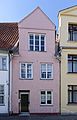
No. 52

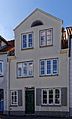
No. 54

# 56
No. 58

No. 62

No. 68

No. 72

No. 74
No. 78

No. 80
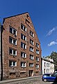
No. 118

No. 130

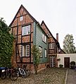
No. 142
# 206

No. 206 on the city wall side


The historical development consists largely of modest small houses from the 14th to 19th centuries, with numerous houses having classicist facades after 1800 .
- see also list of abandoned buildings in Lübeck # Wakenitzmauer for buildings that are no longer in existence.
Corridors and courtyards
The following Lübeck corridors and courtyards go from the Wakenitzmauer (according to house numbers):
- 24: Potzky's gang (missing)
- 30: Pinciers Gang (missing)
- 34: Evers Gang (missing)
- 70: Nagel's walk (missing)
- 132: Calico printer gear
- 164: Kleins Gang (missing)
- 170: Hartog's Torweg (pending)
- 184: Homann's gang (missing)
literature
- W. Brehmer : The street names in the city of Lübeck and its suburbs. HG Rathgens, Lübeck 1889.
- W. Brehmer: Lübeck house names along with contributions to the history of individual houses. HG Rathgens, Lübeck 1890.
- Klaus J. Groth : World Heritage Lübeck - Listed Houses. Over 1000 portraits of the listed buildings in the old town. Listed alphabetically by streets. Verlag Schmidt-Römhild, Lübeck 1999, ISBN 3-7950-1231-7 .
- Max Hoffmann: The streets of the city of Lübeck. In: Journal of the Association for Lübeck History and Archeology. Jg. 11, 1909, ISSN 0083-5609 , pp. 215-292 (also special print: 1909).
Web links
Individual evidence
- ^ Lutz Wilde with the participation of Margrit Christensen: Hansestadt Lübeck. Old town (= monument topography Federal Republic of Germany. Cultural monuments in Schleswig-Holstein. Volume 5.1) . Wachholtz, Kiel / Hamburg 2017, ISBN 978-3-529-02524-2 , pp. 750–762
Coordinates: 53 ° 52 ′ 14.6 " N , 10 ° 41 ′ 37.9" E