Lübeck city fortifications

Sketch of the Lübeck city fortifications by Eugène Viollet-le-Duc
|

View over the Wakenitz to the fortifications from the east - left Mühlentor , in the middle Hüxtertor with water arts , right Burgtor
|

City fortifications from the west 1641, engraving by Matthäus Merian
|

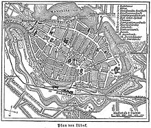
Plan of Lübeck in the 19th century, clearly recognizable the use of the ramparts as a railway line for the LBE
|
The Lübeck city fortifications were one of the most extensive urban fortifications in Northern Germany and Northern Europe and are still partially preserved today.
The fortification of the old town island
When the Bucu hill between Trave and Wakenitz was settled in the course of the foundation of Lübeck in the 12th century, it was realized that the location of the old Liubice, located further down the Trave in the flat grassland of the glacial valley, could not be adequately fortified. The hill Bucu had previously been the site of a Wendish castle and, topographically, had better conditions for fortification and defense. The fortification of the city's foundation in the 12th century consisted of the Lübeck castle, which became a castle monastery after the Battle of Bornhöved , and a city wall and four city gates , of which the castle gate and the Holsten gate in their later structural modifications still bear witness today. It was first mentioned in 1181 by Arnold von Lübeck in connection with the siege of the city by Emperor Friedrich I Barbarossa .
The city wall surrounded the entire old town. At the Trave it was provided with small gates at regular intervals to enable the transport of goods between the port and the city. On the northern edge of Lübeck's old town (along the streets An der Mauer and Wakenitzmauer ), remnants of the medieval city wall have been preserved, some of which were built into houses built in the 17th century.
Landwehr
The system of immediate city fortification was supplemented by a land defense surrounding the city and its extensive external territory , which is largely preserved today as the Lübeck Landgraben . The first defense towers of this partly staggered system were located, for example in Fredeburg, at a distance of more than 25 km from the gates of the city.
A moat from the 14th century, the so-called "Schwedenschanzen" in Lauerholz on the border with Mecklenburg-Western Pomerania, is still well preserved today.
Expansion of the fortifications in the 17th century
From 1613 the city was provided with extensive external fortifications by the Dutch fortress builder Johan van Valckenburgh according to the plans of Johan van Rijswijk, especially towards the south and west. There were mounds piled up and between the Trave and the city ditch bastions in the then most modern form of fortification created. The construction work took about 30 years and was completed by Heinrich von Brussels . The entrances to the city were controlled by the Lübeck city military .
Dismantling of the fortifications
The city council decided to dismantle the fortifications after the neutrality of the three Hanseatic cities had been recognized in the course of the Reichsdeputationshauptschluss of 1803 . Most of the guns were sold. During the French period in Lübeck , the fortress was once again expanded and strengthened by the occupying forces. The demolition of the ramparts began after 1813, but for cost reasons only hesitantly and mostly only where either fortifications were in trouble ( Blue Tower ), became dilapidated ( Hüxtertor ) or the area of the fortifications was needed for infrastructure measures. This was on the one hand the port expansion on the Wall Peninsula with the construction of modern handling facilities and warehouses such as today's Media Docks , on the other hand the construction of the Lübeck-Büchener Railway and especially the construction of the Elbe-Lübeck Canal , which led to significant changes in the topography east of the old town by fundamentally changing the course and extent of the Wakenitz water body (see there). On the other hand, the Kaisertor was exposed again in the course of the canal construction and the associated removal of a bastion. Today the Lübeck ramparts between the Holsten Gate and the Puppenbrücke on the one hand and the former Mühlentor on the other hand are still almost completely preserved and the symmetrical bastions are still clearly visible.
Today, Willy-Brandt-Allee and Possehlstraße run along the route of the 19th century railway .
gallery
literature
- Hespeler: Wehrbauten , in: Der Wagen 1942–1944, pp. 112 to 119.
Web links
- City of Lübeck to the bastions at the Holsten Gate
- Animated film on the history of the Hanseatic city of Lübeck from 1100 to today ( Flash ; 1.2 MB)


